Undiscovering the Mountains of Kong and the Mountains of the Moon
Quick, take a look at this map. There's something wrong with it. It's a map of the coast of West Africa dating from 1839. Compared with modern maps, a few things have changed. Senegambia was the French controlled Senegal and the British controlled Gambia, Soudan is today's Sudan and Upper Guinea is part of today's Guinea. But that's not what's wrong with this map. Take a closer look.
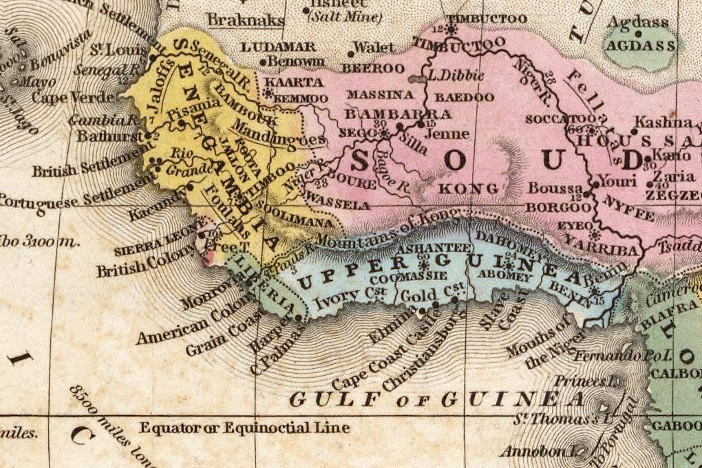
Running along the border between Upper Guinea and Soudan is the Mountains of Kong. If the name of this mountain range doesn't seem familiar, then maybe the next map will help. Dating from 1805, this map by John Cary shows the Mountains of Kong marching eastwards from the western coast of Africa and linking up with the eastern Mountains of the Moon.

There's two major problems with these maps. Neither the Mountains of Kong or the Mountains of the Moon actually exist.
The Moutains of Kong first appeared on a map in 1798, based on explorations of the western coast of Africa by Mungo Park. This map, produced by Englishman James Rennell, showed the River Niger petering out and presumably evaporating in a region which is now Burkina Faso, rather than flowing some two and half thousand miles before joining the Atlantic Ocean via the Niger Delta in Nigeria. Quite why the mountains appeared on Rennell's map is still unclear. Mungo Park's expedition never ventured into the area where the mountains are shown.
The Mountains of the Moon were first reported around 50 AD by Diogenes, a Greek trader who claimed to have found the source of the River Nile after travelling inland from the city of Rhapta, a market city whose location is unclear but it believed to be in what is now Tanzania. Diogenes reported that the Nile rose from a range of snowy mountains, located near two great lakes. He named these snowy peaks the Mountains of the Moon. Today, his great lakes are thought to be Lake Victoria and Lake Nyassa and the Mountains of the Moon are probably the Rwenzori range on the border between Uganda the The Congo.
In the 1800's Africa was still mainly unexplored, which explains the unknown parts label on Cary's map and both the Mountains of Kong and The Mountains of the Moon were still believed to be very much in existence. Subsequent maps of the area continued to show them and through the course of several expeditions, the resultant maps not only continued to show the Kong range, but it actually increased in height and in length, eventually linking up with the equally fictitious Mountains of the Moon

Despite no-one actually seeing this massive, continent spanning mountain range, belief in the Mountains of Kong continued for almost a century. Finally Louis Binger, a French explorer who spent two years from 1887 charting the path of the River Niger was able to prove that the mountain range simply didn't exist. Cartographer quickly took the hint and both mountain ranges vanished from subsequent maps of the area and of Africa ... almost.
The enduring myth of the Mountains of the Moon refuses to die out entirely. The 1928 edition of Bartholemew's Oxford Advanced Atlas still contained the range, albeit only in the index and placing them just south of the town of Korhogo in Côte d'Ivoire. The also had a fleeting reappearance in the 1995 edition of Goode's World Atlas.
Normally we think of the process of early map making as intrinsically linked to the process of discovery, at least from a European perspective, when we were discovering countries and places quite oblivious to the fact that people already lived there. But as the Mountains of Kong and the Mountains of the Moon show, sometimes to make a map you need to undiscover places as well.