Another Category Of Place You Really Don't Want To Check In To

There are some places you really don't want to check into using one of the many location based social networks. There's a variety of suggestions of this nature on the web including funeral homes, an ex-partner's house, jail or the same bar (every night). It now seems you can add military bases (when you're in a war zone) to the list.

Camp Phoenix

A recent report highlighted concerns that the US Air Force has over troops using location based apps, with the Air Force posting a warning on an internal web site on the matter.

"All Airmen must understand the implications of using location-based services," said a message on the internal Air Force network. The features, such as Facebook's 'Check-in,' Foursquare, Gowalla, and Loopt "allow individuals with a smartphone to easily tell their friends their location," it said. "Careless use of these services by Airmen can have devastating operations security and privacy implications," said the message, which was posted on November 5, according to spokesman Major Chad Steffey.

The age old adage about Military Intelligence being an oxymoron springs to mind.

A First Step Towards Indoor Navigation. Literally

The problems started the moment GPS became a commodity and made the transition from the car to the mobile device. Nowadays, GPS can be found in a vast range of smartphones and navigation is possible without being confined to your car. Of course, it's not always a great experience. GPS works best when there's a direct line of sight to the satellites whizzing around over your head and there are times when you just can't get a GPS lock. A-GPS was devised to help with such situations, allowing your location enabled to device to take advantage of a variety of other sensors, such as cell tower and wifi triangulation technologies.

But even then, GPS just doesn't work indoors most of the time and indoor location and routing has become something of the Holy Grail for navigation technology vendors. Granted there have been lots of technologies developed which use non A-GPS technologies such as RFID and other near field sensors. But so far these all require a not insignificant investment to install and require specialist devices to take advantage of; none of which are as ubiquitous as the combination of smart phone and GPS.

Maybe we're looking too deeply at this challenge. Take a category of location that lots of people go to, such as shopping malls, where GPS usually isn't available, and map each mall to a high degree of accuracy, both in terms of the layout of the mall and in terms of the stores and concessions in that mall. Add in key features, such as multiple levels, staircases, escalators and lifts and you can build a spatial map of the mall which doesn't need sensors. Simply tell your phone where you are and where you want to go and you can provide simplistic directions, without the need for GPS.

Through The (New Office) Window

At the weekend myself and the rest of the Ovi Places team found ourselves re-geolocated from the Nokia office in Invalidenstraße in the Mitte district of Berlin to a new office in Schönhauser Allee in the Prenzlauer Berg district. While the office coffee hasn't improved, the view from my desk certainly has.

Through The (New Office) Window

From left to right the view takes in the Fernsehturm, (East) Berlin's TV tower, Schönhauser Allee, looking towards Rosa-Luxemburg-Platz U-Bahn station on the U2 line and the dome of the Berlin Cathedral, better known as the Berliner Dom. I could get used to this view.

Location vs. Place vs. POI

With Nokia, Google, Facebook and a whole host of other players recognising the inherent value in the concept of Places and Points Of Interest (POIs), it's good to see that the World Wide Web Consortium (W3C), the standards body of the Web, is getting involved. On the 30th. September 2010, the W3C Points Of Interest Working Group (POIWG) was launched with a "mission to develop technical specifications for representation of POI information on the Web". I should pause to make a brief disclaimer here; I'm sitting on the POIWG as part of my day job with Ovi Places at Nokia.

Of course, in order to develop those technical specifications, we need to define what a POI is in the first place. There's a lot of acronyms flying around (3 in the first paragraph of this post alone) and a lot of conflicting terminology further confusing the matter. Even the most cursory of glances through Web content on this topic shows the terms Place, Location and POI being used interchangably and so as part of the discussion I tried to codify the difference between, and most importantly the inter-relationships between, these three seemingly straightforward terms. The genesis for this post first appeared on the POIWG public mailing list last week (and W3C working groups conduct their business as much as possible in public) but I've fleshed it out in a bit more detail here.

The More The Web Changes, The More It Stays The Same (With A Map)

There's a saying in French which goes "plus ça change, plus c'est la même chose" which translates as the more things change, the more they stay the same. Maybe the same could be said to apply to today's World Wide Web ... "plus les changements web, plus le web reste le même", the more the Web changes, the more the Web stays the same, with blame firmly put at Google Translate if this doesn't translate properly.

Costa Rica And Nicaragua; A Border Dispute In The Age Of Web Maps

The popular press and media likes nothing better to poke fun at people who seem to ignore their own senses and instead rely on their GPS sat-nav systems, which frequently results in people ending up in the middle of fields, in the middle of rivers or even, in extreme cases, almost driving off of the edge of a cliff.

But the strangest example of this sort of behaviour was in the first reports of recent events on the border of Costa Rica and Nicaragua that seemed to implicate Google Maps as justification for Nicaraguan troops crossing the border into Costa Rica and raising the Nicaraguan flag on Costa Rican territory. The dispute seems to hark back to the 1850's where the contested border between the two countries followed the course of the San Juan River, the course of which has since moved somewhat, as rivers are wont to do. Costa Rica asserts their sovereignty on the disputed land based on the 1850's arbitrated border which follows the course of the river and Nicaragua asserts theirs based on the fact that the river has moved so some land must be theirs.

The BA Mobile Boarding Pass; So Right And Yet So Wrong

While boarding passes on your mobile handset have been around for a while in one form or another, I only came across them just over a year ago while flying on KLM from Amsterdam's Schipol airport. The system was quick, easy and worked, even though some of the staff at Schipol seemed a bit confused by me whipping out my mobile when they asked for my boarding pass, rather than the conventional printed boarding pass. At the time, I wondered when British Airways would follow suit. Now more than a year later, they have. Now to be fair, this system may have been in place for a while, but if it was it escaped me. Maybe I missed an email or some junk mail about this, but the first I heard of it when when I saw that the BA app on my iPhone had a new version and after some poking around to see what was new I saw the option for a mobile boarding pass.

Flight Safe Mode; The Sequel

This is mercifully brief follow up to my previous post on British Airways proscriptions on enabling flight safe mode on your mobile phone and hails jointly from the departments of "be careful what you ask for, it might come true" and "they didn't really mean to say that ... did they?" ...

On this morning's flight from London Heathrow to Berlin's Tegel the usual flight safety announcement was made, but with a couple of significant, if contradictory, changes.

Takeoff!

"All electrical devices should be switched off during take off, landing and when the engines are running, some devices may be used after take off, please see High Life magazine for more information. If your mobile phone has a flight safe mode, it should be enabled now, before switching off the device and ensuring it is stowed in an overhead locker".

Neogeography Is Dead (According To Wikipedia At Least)

Ahh ... paleogeography and neogeography; will the battle never end? The latter is a term used to refer to the combining of online mapping with data, incorporating classic cartography and GIS and exposed via Web 2.0 style mashups. The former is a term with dual meanings; one referring to the study of past and ancient geography and one being a pejorative to refer to the opposite and inverse of neogeography.

Good News

Both terms have their own entries on Wikipedia ... at least they used to. Towards the end of September 2010 the neogeography entry on Wikipedia was deleted with the justification ...

Berlin, Graffiti and Maps

Like most cities these days, there's a lot of graffiti in Berlin. Some of it is just the mindless repetitive tagging where someone feels the need to display his or her tag over as much surface area as possible. But some of it aspires to art, especially the large displays found on the sides of buildings and high up on walls. A great example of this is the massive question (or maybe it's a statement) of How Long Is Now, found on the side of the Tacheles on Oranienburgerstraße, complete with a giant cockroach emerging from the wall.

How Long Is Now?

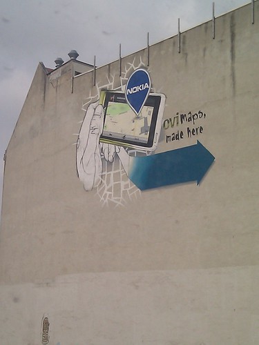
This grand painting style, part graffiti, part mural, part art seems to be iconic to a lot of the Mitte area of what used to be East Berlin. With this in mind, it's good to see that Nokia has decided to join in with this peculiarly Berlin trait with its own contribution, telling visitors walking along Invalidenstraße towards Nordbahnhof precisely what goes on in the Nokia Gate5 offices ... Ovi Maps, made here.

Ovi Maps. Made here. In Berlin