Posts about agi

Of W3G, AGI And Other Geographical Acronyms

I was at GeoMob's very first event, talking about Yahoo's Fire Eagle location brokering platform. Four years later and it was great to go back, see GeoMob still flourishing despite a brief hiatus in 2010, and meet up with a lot of old friends as well as meet some new ones.

And what an evening it was. Truly a veritable feast of maps. David Overton spoke about SplashMaps, his Kickstarter funded project to produce lightweight printable fabric maps for outdoors.

I didn't think it was possible to map happiness but apparently it is and George MacKerron showed how with the aptly entitled Mappiness project.

In November 2008 I was still working for Yahoo and a fledgling meetup event for people interested in maps, location, geo and mobile started up in London. It was, and still is, called GeoMob. I was at GeoMob's very first event, talking about Yahoo's Fire Eagle location brokering platform. Four years later and it was great to go back, see GeoMob still flourishing despite a brief hiatus in 2010, and meet up with a lot of old friends as well as meet some new ones.

And what an evening it was. Truly a veritable feast of maps. David Overton spoke about SplashMaps, his Kickstarter funded project to produce lightweight printable fabric maps for outdoors.

I didn't think it was possible to map happiness but apparently it is and George MacKerron showed how with the aptly entitled Mappiness project.

Staying with tangible maps, Anna Butler from Wellingtons Travel wowed the audience with her lovingly hand drawn map of the centre of London, styled after the glorious illustrated maps of yesteryear. Almost all the audience immediately added a copy of her map to their Christmas lists en masse.

Awesome hand-drawn map of London is awesome #geomob

And then there was James Cheshire who, along with Ollie O'Brien, runs Spatial Analysis and they'd produced Lives On The Line, a map of the life expectancy of Londoners along the path of the London Underground lines. Not only maps, but Tube maps. What more can you want?

Finally, standing between the audience and a thirst quenching GeoBeer or two, it was my turn. This wasn't my usual talk. No mapporn. Not even that many pithy or wryly amusing images. Just some raising of awareness for the W3G conference and the AGI. As usual, the slide deck is below and the notes follow after the break.

[scribd id=114211713 key=key-1fshphqj3fe65ojic5s7 mode=scroll]

Slide 2

So, hello, I’m Gary and I’m from the Internet. I’m a self-confessed map addict, a geo-technologist and a geographer. I’m Director of Web & Community for Nokia’s Location and Commerce group. Prior to Nokia I led Yahoo’s Geotechnologies group in the United Kingdom. I’m a founder of the Location Forum, a co-founder of WhereCamp EU, I sit on the Council for the AGI, the UK’s Association for Geographic Information, I’m the chair of the W3G conference and I’m also a Fellow of the Royal Geographical Society.

Slide 3

There are URLs in this talk but this is the only URL in the entirety of this talk you might want to take a note of. Although if you go there right now, it’ll 404 on you, later today or tomorrow, this is where this slide deck, my notes and all the links you’ll be seeing will appear on my blog. That’s a lower case “l” and a lower case “h” at the end of the URL by the way ...

Slide 4

Before I get started I just want a moment to pay my respects to the first mapping API I ever used in anger. After being slated for closure in September of last year, the Yahoo! Maps API finally got turned off round about 1.30 PM London time today.

Slide 5

Now, despite being the aforementioned map addict, I'm not going to be talking about Apple's recent foray into the world of smartphone based digital mapping, tempting though it is.

Slide 6

It also looks like at least one member of the audience tonight was hoping to hear about Nokia's new Here maps platform.

Slide 7

But I'm not going to be talking about that either I'm afraid, though if GeoMob invites me back I'll be more than happy to do so.

Slide 8

Instead, my brief talk tonight starts off with "Hello, I'm Gary and I want to talk to you about W3G and the AGI" ...

Slide 9

So what's the best possible outcome from a statement like that from you, the audience?

Slide 10

It's probably something along the lines of "Ah. Yes. W3G. We've heard about that conference. Err. What's the AGI?".

Slide 11

That's the best outcode. But is it a realistic outcome?

Slide 12

That's probably along the lines of "The AGI? Oh yes. That's the GIS organisation. Nothing to do with me".

Slide 13

But actually there's a more probable outcome ...

Slide 14

It's along the lines of "Eh? W3G? That's the World Wide Web Consortium and you've spelt it wrong. AG what? Never heard of 'em".

Slide 15

So to change this probable outcome, it's time for some audience participation, which involves nothing more than sticking your hand up in the air.

Slide 16

Who here uses or works with maps? Maps APIs? Big Data? LBS? LBMS? Anything related to the concept of "geo"?

Slide 17

Despite the glorious maps we look at and work with, today's digital maps that we interact with are just the tip of the iceberg and what we all work with is really GI ... Geographic Information.

Slide 18

And this is where W3G comes in.

Slide 19

W3G is an (un)conference. The parentheses are important here. It's the unique combination of invited guest speakers and open format foocamp style unconference sessions.

Slide 20

We've probably all encountered what I call the conference curve of despair. Where you see a conference you'd like to attend but it's too expensive and it's not even in the country you live in, let alone the city you live in.

Slide 21

But W3G follows the unconference line of elation. It's free and it's local.

Slide 22

Next year will be W3G's fourth consecutive year.

Slide 23

W3G 2010's theme was the 3 W's of Geo, the where, the what and then when

Slide 24

In 2011 the theme was that there's more to Geo than merely just maps and check-ins.

Slide 25

But just because W3G is free to attend doesn't mean it's free to put on. We're able to do his through the cold hard cash that our sponsors put up and also because of W3G's parent ...

Slide 26

... the AGI ... the UK's Association For Geographic Information. The AGI is uniquely positioned to inform, react, connect and communicate on all matters relating to geographic information. From startups to global enterprises. From developers to business development. From local to central government. From classic GIS through to whatever the successor to Web 2.0 is called these days. I think it's a worthy endeavour. So much so that I sit on the AGI's governing council.

Slide 27

If you think this is a worthy endeavour and want to find out more, the interwebs can help.

Slide 28

W3G maintains a web site and a Twitter feed

Slide 29

And so does the AGI. Take a look. Get in touch. Thank you.

Of Digital "Stuff" And Making Your Personal Interweb History

Big (Location) Data vs. My (Location) Data, which was the theme for a talk I gave at the AGI Northern Conference. The TL;DR premise behind the talk was that the location trail we generate on today's interweb is part of our own digital history and that there's a very one sided relationship between the people who generate this digital stuff and the organisations that aim to make money out of our digital stuff.

Once I'd given that talk, done the usual blog write up and posted it, I considered the topic done and dusted and I moved onto the next theme. But as it turns out, the topic was neither done, nor dusted.

Firstly Eric van Rees from Geoinformatics magazine mailed me to say he'd liked the write up and would I consider crunching down 60 odd slides and 3000 odd words into a 750 word maximum column for the next issue of the magazine.

Back in July, I wrote about Big (Location) Data vs. My (Location) Data, which was the theme for a talk I gave at the AGI Northern Conference. The TL;DR premise behind the talk was that the location trail we generate on today's interweb is part of our own digital history and that there's a very one sided relationship between the people who generate this digital stuff and the organisations that aim to make money out of our digital stuff.

Once I'd given that talk, done the usual blog write up and posted it, I considered the topic done and dusted and I moved onto the next theme. But as it turns out, the topic was neither done, nor dusted.

Firstly Eric van Rees from Geoinformatics magazine mailed me to say he'd liked the write up and would I consider crunching down 60 odd slides and 3000 odd words into a 750 word maximum column for the next issue of the magazine.

And then a conversation on Twitter ensued where some people immediately saw the inherent value in their personal location history whilst some people ... didn't.

That conversation was enough to make me go back and revisit the theme and the talk morphed and expanded considerably. Fast forward to this week and I've given the talk in its' new form twice, once at Nottingham University's GeoSpatial faculty and once at the Edinburgh Earth Observatory EOO-AGI(S) seminar series at Edinburgh University.

Maybe now this topic and this talk is finished and it's time to move on. But somehow, I think this will be a recurring theme in talks to come over the next few years.

The slides from the talk are below and the notes accompanying those slides are after the break.

[scribd id=111913058 key=key-15vmdecagp3xopiyihgt mode=list]

Slide 2

So, hello, I’m Gary and I'm from the Internet. I’m a self-confessed map addict, a geo-technologist and a geographer. I’m Director of Web & Community for Nokia’s Location and Commerce group. Prior to Nokia I led Yahoo’s Geotechnologies group in the United Kingdom. I’m a founder of the Location Forum, a co-founder of WhereCamp EU, I sit on the Council for the AGI, the UK’s Association for Geographic Information, I’m the chair of the W3G conference and I’m also a Fellow of the Royal Geographical Society.   Slide 3

There are URLs in this talk but this is the only URL in the entirety of this talk you might want to take a note of. Although if you go there right now, it'll 404 on you, later today or tomorrow, this is where this slide deck, my notes and all the links you'll be seeing will appear on my blog. That’s an upper case “I” and a zero at the end of the URL by the way …   Slide 4

This is not a talk about GIS. This isn't even a talk about GI or geographical information in the usual sense of the words. Nor is this the talk I sat down and started to write. That talk was going to be about how maps are now mainstream and how we’ve managed to find ourselves in the middle of something that could be called a ‘map war’, with Nokia, TomTom, Google, Apple and OpenStreetMap battling it out for overall geospatial supremacy. But I didn’t write that talk. The topic reeked of far too much schadenfreude for me to be comfortable with the topic. So I stopped writing that talk and started to think about another suitable theme. Then something happened.   Slide 5

A while back I’d written a talk about the digital history that we are currently creating on the internet. The talk was called ‘Big Data vs. My Data’. I gave the talk at two conferences and it seemed to go down well, which is always gratifying.   Slide 6

So I filed the talk away, wrote a blog post on it, and considered the topic pretty much finished. It wasn’t.   Slide 7

Then Eric van Rees, the editor of Geoinformatics Magazine got in touch. He said that he’d liked the blog post I’d written and the slide deck notes and would I be willing to convert the talk into a magazine column. So I sat down and tried to condense a 3000 odd work talk, spread over around half an hour into a 750 word printed column. Eventually I succeeded, it got published and people seemed to like it. This was also gratifying.   Slide 8

So now I really considered the topic pretty much finished. It still wasn’t.   Slide 9

The topic ended up spawning one of those long conversations on Twitter, where some people agreed with me and some …. didn’t.   Slide 10

So I went back and revisited the topic and decided it really wasn’t finished. Hopefully this version is the final definitive finished version.   Slide 11

This is a talk that goes off in lots of different directions but fundamentally it’s about these two sets of geographical coordinates. Most people here should recognise them as two sets of latitude and longitude. Some of the frighteningly scary people I’ve worked with could probably tell you what country they’re in, just by looking at them. A few, really frighteningly scary people that I know could probably even tell you what city they’re in. But I won’t make you do that. The first coordinate is where I live, near Twickenham Rugby Stadium in West London. The second is pretty much where we are now, in the Old Library in the University of Edinburgh. Why this talk is about these two sets of coordinates, and quite a few other coordinates besides, will, I hope become clearer over the next half an hour or so.   Slide 12

One of the things I love about writing a talk is how the things I hear and the things I read and write get mentally stored away and then, somehow, they start to draw together to form a semi-coherent narrative around the talk title that I inevitably gave to the conference organisers around 3 months prior. So it is with this talk, which in Sesame Street fashion, has been unknowingly brought to you by ...   Slide 13

Kellan Elliott-McCrea, previously at Flickr and Yahoo! and now at Etsy ...

Aaron Straup Cope, previously at Flickr and Stamen Design and now doing stuff at the Smithsonian ...

... and my children. No, really. This isn't just an excuse to put a photo of my family up on the screen behind me so you can all, hopefully, go "awww".   Slide 14

But before I get into anything to do with making history, big data, my data or anything interweb or social network related I want to try and frame the context of my thoughts by talking about communication, or to be more precise, the way in which we communicate. We are, politics and warfare aside, a social species and communicating with each other is something we do a lot of, although the manner in which we communicate has changed a lot.

A lot of our communication is both verbal and non-verbal and relies on face to face, person to person, proximity so that the verbal and non verbal approach comes together to express what we intend to say.   Slide 15

Some of our communication is written, the old fashioned way, using pen and paper, although a lot of commentators have called out the "death of the letter". Whether that's true or just good headline making hyperbole remains to be seen, but to be fair, I can't remember the last time I actually sat down and wrote a letter.   Slide 16

A lot of our communication is still verbal but via a phone, be that a land line or a mobile. We call and we text. A lot.

Slide 17

But be it talking face to face, texting someone or even writing an email, the intended audience is still narrow, person to person, or person to small audience.

But the interwebs have added to this sphere of communications and now we broadcast our thoughts, feelings and experiences, sometimes regardless of whether we think anyone will see this, let alone empathise or communicate back.   Slide 18

While we still talk, meet, engage and sometimes broadcast, like I'm doing right now, this human-to-human interaction has been augmented, maybe complimented by electronic communications.

Slide 19

We're as likely to post a Tweet on Twitter or a status on Facebook or Google+ or another social network as we are to speak face to face.   Slide 20

And because this type of communique is electronic, that means it generates data as we go. Today we generate lots of data, big data, on a daily basis. It's probably not unfair to say that there's data being generated in this very auditorium, right now, as I'm saying this.   Slide 21

We all seem to be doing this, though ‘all’ is a sweeping over generalisation, but enough of us are making digital ‘stuff’ for it to start to matter and for it to start to be significant.   Slide 22

Some of this data is implicit. A by-product of what we're doing. Whether it's our cell phones loosely mapping out where we are, not a privacy invasion I hasten to add, but the simple way in which cellular networks work, but that's a topic for another talk on another day, or our GPS navigation, be it built into our car or our smartphone, providing anonymised traffic data probes to show where freeway congestion is, we don't consciously set out to generate this data. It's a by product of what we're doing.   Slide 23

But a lot of this data is very much explicit. We type out a status update on our phone, our tablet, our laptop and we tap or click on the button that says "go" or "submit" or we take a photo, maybe add an image filter or a comment and tap or click the button that says "share" or "upload".   Slide 24

By doing this we're explicitly communicating, explicitly broadcasting and sharing with our friend, family, followers and the interwebs in general ... and in doing so, we're playing our part in generating more and more data.   Slide 25

And generate it we do. Lots of it. We call it big data, but massive data would be a more accurate definition of it. Whilst our own individual contributions to big data may not be that big, when you put it all together it's part of an ever growing corpus of big data and there's companies that both provide the means for us to broadcast and share this data as well as, hopefully, providing a means of revenue for them to enable them to keep doing this. The amounts that get generated each day is almost too much for us to think about and comprehend. Once a number gets that big, we can't really deal with it. We know it's a big number but what that actually represents is hard for us to get our head around.   Slide 26

So let's look at just a small sample of what gets generated on a daily basis from the social big data, communicating, sharing and broadcasting services I tend to use, if not on a daily basis then at least on a weekly basis. I Tweet and update my Facebook status at least once a day, sometimes up to 20 times a day. I check-in to places on Foursquare at least 10 times a day and take and upload photos to Instagram and Facebook around 3 times a week. That's just my contribution, think how many people are doing the same thing to get to the sort of volumes you can see on the slide behind me.   Slide 27

As a specific example, I post a single Tweet on Twitter. Weighing in at 72 characters, including spaces and punctuation, it’s only just over half of Twitter’s 140 character maximum. That Tweet is assigned a unique identifier by Twitter, which forms part of the unique URL to that single Tweet. From visiting that URL I can see that Twitter has added who I am, when I posted that Tweet and because I geotagged the Tweet, also where I was when I wrote it. So that’s a little more additional metadata than the 72 characters of the Tweet itself.   Slide 28

But if I then take that unique identifier and fire it back at Twitter’s API, I start to see just how much metadata has been added.   Slide 29

115 lines of JSON come back to me from that API call, making up 3,338 characters. There’s metadata on the Tweet itself, when it was created, the text of the Tweet, what app I was using to Tweet with, there’s information on my Twitter account, my name, my Twitter name, my account’s unique identifier, my general location, my biography, all the stuff that’s in my Twitter profile. There’s how many Tweets I’ve posted (14,811 at the time), how many followers I have, how many favourites I’ve flagged, how many Twitter lists I appear in. There’s the details of my profile on Twitter’s web site, HTML colours, profile image URL and the like. And because I’ve geotagged the Tweet, there’s the full geographic information about where I was including a bounding box of the locality.

All of a sudden I can see just how Big Data got its name.   Slide 30

But how long will all of this continue? Remember the people I spoke about right at the start of this talk, some 16 slides back? It's time to bring them into the picture. Firstly, my children, although this applies equally to pretty much all children. Remember when you were a child? The summer holidaywas endless. The skies were always blue and the sun was always out (remember, I'm from the UK where Summer and sun do not always go together, in fact it was pouring down with rain as I wrote this at home last week). And just like the summer holidaywas endless, so were your parents and the people around you, they were eternal and would always be there. Remember feeling like that? But then the inevitable happened. We grew up and we discovered, often the hard way, that the summer wasn't endless and that almost everything is finite.   Slide 31

Social networks aren't finite either. They get born, if they're lucky they grow and then at some time or other they ... stop. If it's a social network you don't use then it doesn't really bother us much.

Slide 32

But if it's a network you've shared a lot of content through, what happens then? A lot of people, myself included, immediately get into "I want my data back" mode.   Slide 33

But is it your data. Of course it is. You made it. You composed that Tweet. You shared that link. You took that photo. You were at that place you checked-in at. Of course it's your data.

But there's a point to be made here. You may have created that data, you may own that data, but the copy of that data in that social network is just that. It's a copy. It's not necessarily "your" data and because most of us don't preserve what we send up into the cloud on its way to our social networks, you may have created it, but the copy in the cloud isn't necessarily yours.   Slide 34

It's an easy mistake to make. I may be a geo-technologist and many more things besides, but I am not a lawyer, and apart from the lawyers in the room, more of you aren't and most of the people who use social networks aren't lawyers either, unless it's DeferoLaw, which is a social network for the legal profession.   Slide 35

... we see phrases like "you retain your rights" ...   Slide 36

… another favourite is “you own the content you posted”   Slide 37

... and "you always own your information" and immediately the subtleties and complexities of data ownership, licensing, copyright and intellectual property are cast aside. We say to ourselves, "it's my data dammit, I own it, I want it".   Slide 38

And it's this belief that we really are lawyers in our spare time that makes people think that somehow the data they've shared via a social network is physically theirs, rather than a bit for bit perfect copy that we've licensed to that social network. We forget for a moment that we're using that social network as a cloud based backup, in some cases the only backup, of our creations and we mutter darkly about "holding my data hostage".   Slide 39

The blunt, and often harsh reality, is the age old adage that "you get what you pay for". If you pay, you're probably a customer. If you're using something for "free" (and I say free in very large italics and inverted commas here), then you're probably, unknowingly or unwittingly, the product. Harsh. But fair. It's our content that the social networks monetize and that allows them to keep their servers and disk storage up and running. You might have seen that previous slide with the Tech Crunch post and be thinking "ah, but Flickr Pro is chargeable and if my subscription lapses I can't get my photos back". That's actually not really true, if not particularly simple, but bear with me for a few more slides.   Slide 40

Now let's forget "big data" for a moment and think about "your data" instead. Actually, let's think about "my data" for a moment. As of last week, my social media footprint on Twitter, Foursquare, Instagram and Flickr looked something like this. Facebook's numbers would be up there too, but I'll get to that in a moment.

Now in the grand scheme of things, in the massive numbers thrown about around about "big data" this is but a drop in the ocean. But ...   Slide 41

I created these check-ins, status updates, tweets and photos. They're important to me. Very important to me.   Slide 42

And as Aaron Cope pointed our earlier this year, my small, insignificant contribution to big data is part of my own, very subjective, very personal, history.

Slide 43

As I may have mentioned before, I'm a geo-technologist and a high percentage of my explicit big data contribution has a geo or location component to it. I'd like to map our where I checked-in, I'd like to see where I was when I Tweeted or what photos I took at a particular location. Some of this "mappyness" already exists in some of the big data stores where my contributions live, but not all of it, it's far too niche and personal for that. But it's still important to me.   Slide 44

Remember, in 99% of the social networks I use, I'm not the customer, I'm contributing to the product. But how do my regularly used social networks fare here. Regardless of whether I own the data I put up there, how easy is it to get a copy of?   Slide 45

Firstly, what about a one click solution? Can I go to a particular page on the web and click the big button which says "give me a copy of my data".   Slide 46

Facebook is the only one of my 5 social networks that does this. Well, it almost does this. At least I'm sure I used to be able to do this.   Slide 47

I can still request a download of my information. But it now only seems to give me my status updates since I enabled Timeline on my account, though I can still get all of my photos and messages since 2008. Rather than say that this doesn't work, I'll just file this under "needs further investigation" and move on.   Slide 48

Sometimes this lack of a one button download of contributed data is a deliberate decision on the part of a given social network. Sometimes, it's a hope that with an API, some enterprising developer will do this, but most of the time, that doesn't always happen.   Slide 49

So talking of APIs, surely the remaining social networks will have an API and let me knock up some code to get a copy of my data contributions. Surely?   Slide 50

Not all social networks do. An API tends to come after a social network's launch, if it comes at all, and often it doesn't let me do all that I want to do.   Slide 51

Thankfully, all the networks I used, with the exception of Twitter not only provide an API, but let me use that API to get my data. All of my data.   Slide 52

This is a good thing and meets the requirements for an API to meet what Kellan Elliot McCrea calls "minimal competance". He went on to say

"The ability to get out the data you put in is the bare minimum. All of it, at high fidelity, in a reasonable amount of time.

The bare minimum that you should be building, bare minimum that you should be using, and absolutely the bare minimum you should be looking for in tools you allow and encourage people who aren’t builders to use."   Slide 53

Kellan was behind Flickr's API and his sentiments are, to my mind, admirable.

Slide 54

Sadly, Twitter doesn't let me do this and fails the minimal competence test miserably. Deep in their API documentation I found the justification for this as being essential to ensure Twitter's stability and performance and leave it as an exercise to you the audience to work out what I think of this excuse.   Slide 55

The sad truth here is that when it comes to our own individual online data history, there's not always a willingness to make it easy for us to get copies of our history, if it's even on the radar at all.   Slide 56

But if we can't always get our data history back, maybe the solution is to make an archive of it before it goes in or keep that archive up to date as you go ... a personal digital archive or PDA (and not to be confused with personal electronic organisers, or PDAs, such as the Palm Pilot).   Slide 57

Thanks to web APIs and another social network, admittedly one for people who know how to code, a lot of this is already possible and the scope, range and functionality is growing by the day. The irony that I can build my own personal digital archive out of code found on another social network, which itself is built around a source code archival system is not lost on me either.   Slide 58

So, firstly, there's my own Instagram (and no, I'm not going to share the URL of where this lives I'm afraid. The idea here is that this is a personal archive, not a clone of a social network).   Slide 59

My own Instagram is called parallel-ogram. It's on GitHub; you can download it, configure it, run it. For free.   Slide 60

Parallel-ogram works as well on my phone as it does on my laptop, showing me exactly what I've uploaded to Instagram. Indeed, it goes one step further than Instagram as currently there's no way to see what you've uploaded other than through their mobile app. Parallel-ogram doesn't allow me to take photos or upload them, at least not yet, but it does allow me to go back to the day I first uploaded a photo, grabs copies for me and twice a day it uses the Instagram API to see what I may have uploaded and quietly grabs a copy and stashes it away for me.   Slide 61

There's also my own archive of Foursquare ...

Slide 62

It's called privatesquare and it's also on GitHub   Slide 63

Like parallel-ogram, privatesquare quietly uses the Foursquare API to go back to my first check-in and twice a day quietly synchs my check-ins for me. I can go back and look at them, see maps of them and browse my check-in history. Unlike parallel-ogram, privatesquare also allows me to check-in, even if I don't want to share this with Foursquare. In short it allows me to use it both as an archive and also as a check-in tool, and if I want to use Foursquare's official mobile app, I can do that, safe and secure in the knowledge that privatesquare will keep itself up to date.   Slide 64

My photos also end up on Flickr and there’s a private archive of that too   Slide 65

It's called parallel-flickr, it also lives on GitHub and it's also filed under "something I really must install, configure and get running when I have some spare time".   Slide 66

So I have my own archives of Instagram, Flickr and Foursquare. I sort of have my own archive of Facebook. But what about my Tweets?   Slide 67

Well until Twitter decides that their site is stable enough to let me grab my Tweets through their archive, the next best solution is to archive by another means. I've put the RSS feed to my Tweet-stream into Google Reader, which helpfully never throws anything away. I did this a long time ago and I have almost all, but 100% all of my Tweets. Now all I need to do is write some code to read them from Google Reader and then get the Tweet data from Twitter, which then do allow via their API. Sadly, this is also filed under "something I must do when I have the time". It's not perfect, but then again, none of what I've discussed is, but it's a start and that's good enough for the time being.   Slide 68

Finally, you might have noticed the links in my slides look sort of like bitly links, only on the vtny.org domain. That's because I've been archiving my short links for a few years now   Slide 69

Using my own short URL archive and my own, self hosted, URL shortener. I just thought I'd mention that.   Slide 70

So, my big data contribution, my personal online history, is important to me. Yours might be important to you too. We're often told that we can't have our cake and eat it, but with the advent of the personal digital archive, maybe we can thanks to the enterprising people who create APIs in the first place and those who not only use these APIs but also put their code up for all the world to use, free of charge. Your online history may not be that important in the grand scheme of things, but it's your online history, it's personal, you made it. When social networks go the place where software goes to die, you might just want to preserve that personal history before the servers get powered off forever. Maybe the geeks will inherit the Earth after all.   Slide 71

I want to wrap up with a slightly cautionary tale, which highlights why our digital stuff and interweb history might just be important in ways you might not immediately think of. A friend of a friend, called Claudio, received a call from the British Transport Police in June of last year. There'd been an assault at Leicester Square Tube station in which an unfortunate individual ended up with broken ribs. The Police had evidence that placed Claudio at the Tube station at the time the assault took place. Could he explain what he was doing at that place and time. It's worth noting here that the assault had taken place in December of 2010, almost 7 months prior.

I wonder how many of us could say with certainty where we were, what we were doing and whether there was anyone to corroborate this without recourse to some form of aide memoire.

For Claudio, it was entirely feasible that he was at Leicester Square on the night of the assault but worryingly, there was large gaps in his recollection and that of his friends.

Thankfully, by mining his web history and that of his friends he was able to piece together the events of the night, with some additional proof in the form of geotagged photographs.

As the cliche goes, Claudio was eliminated from the enquiries but what I find particularly telling about this anecdote is the strong web history and Big Data elements to it. The initial accusation was built on Big Data, namely Claudio was one of those people who used his Oyster Card to enter the Tube station, which left a date and time stamped record. In fact, the date and time that he entered the station was precisely the same time that the person, captured on CCTV, entered the station. Once the full picture was in place, it could be seen that Claudio was not the suspect that the Police were looking for. But not only was the potential accusation built on Big Data but the defence, the alibi and the proof of his innocence were built on Big Data and people's web histories as well.   Slide 72

It wouldn't be an outrageous prediction to see that this sequence of events might start playing themselves out a lot more in the not too distant future as we grow ever more reliant on web based services, Big Data stores and as those data stored start to be interlinked.

The whole tale is worth a read; you'll find it at the end of the URL on the screen behind me.   Slide 73

Thank you for listening.

Talking GeoBabel In Three Cities (And Then Retiring It)

can I adapt, cannibalise or repurpose one of my other talks?". This sometimes works. If there's a theme which you haven't fully worked through it can serve you well.

But a conference audience is an odd beast; a percentage of which will be "the usual suspects". They've seen you talk before, maybe a few times. The usual suspects also tend to hang out on the conference Twitter back channel. Woe betide if you recycle a talk or even some slides too many times; comments such as "I'm sure I've seen that slide before" start to crop up. Far better to come up with new and fresh material each time.

You're invited to speak at a conference. Great. The organisers want a talk title and abstract and they want it pretty much immediately. Not so great; mind goes blank; what shall I talk about; help! With this in mind, my first thought is normally "can I adapt, cannibalise or repurpose one of my other talks?". This sometimes works. If there's a theme which you haven't fully worked through it can serve you well.

But a conference audience is an odd beast; a percentage of which will be "the usual suspects". They've seen you talk before, maybe a few times. The usual suspects also tend to hang out on the conference Twitter back channel. Woe betide if you recycle a talk or even some slides too many times; comments such as "I'm sure I've seen that slide before" start to crop up. Far better to come up with new and fresh material each time.

But sometimes you can get away with it and so it was with my theme of GeoBabel. Three conferences: the Society of Cartographers Summer School, The Location Business Summit USA, AGI GeoCommunity 2010. Three cities: Manchester, San Jose, Stratford-upon-Avon. Three audiences: cartographers, Silicon Valley geo-location business types, UK GIS business types.

I've written about GeoBabel before; it's the problem the location industry faces as we build more and more data sets which are fundamentally incompatible with each other. This incompatibility arises either due to differing unique geographic identifiers, where Heathrow Airport, for example, is found in each data set, with differing metadata and a different identifier, or due to different licensing schemes which don't allow data to be co-mingled. We now have more geographic data than before but each data set is locked away in its own silo, either intentionally or through misguided attempts to be open.

The slide deck, embedded above, is the one I used in San Jose. The ones for Manchester and for Stratford-upon-Avon are pretty much identical but are on SlideShare as well.

As another way of illustrating the problems of GeoBabel, I came up with what I've termed The Four Horseman Of The Geopocalypse. All very fin de siecle but it seemed to be understood and liked by the audience at each talk.

The first Horseman is not Pestilence but Data Silos. All of the different types of geographic data we have, international and national commercial data, national and crowd sourced open data, specialist and niche data and social network crowd sourced data each live in isolation to each other with the only common denominator being the geo-coordinates each data set's idea of a place has.

The second Horseman is not War but Licensing. Nowadays in the Web 2.0 community we're used to having access to data but we're not willing to pay for it. Licenses vary between closed commercial licenses and open licensing. But even in the open license world there are silos, with well meaning licenses becoming viral and attaching themselves to any derived work.

Which segues neatly to the third Horseman, who's not Famine but Derivation. Each time you create something from data, you're deriving a new work in the eyes of most licenses and that means the derived work often has the original license still attached to it. You do the work, but you don't own the work.

Finally, the fourth Horseman is not Death but Co-Mingling. There is no one single authoritative geographic data set, you need to find the ones which work for you and for your business or use case. That means you need to mingle the data sets and frequently the licenses you have for those data sets explicitly prohibit this.

Babel by Cildo Meireles

But now after three outings, it's time to retire GeoBabel, for now at least, just as I retired my Theory Of Stuff earlier this year. That means I had to find a new theme to talk about at my next event, the Geospatial Specialist Group at the British Computer Society. But that's in my next post.

Photo Credits: Nick. J. Webb on Flickr.

W3G – A Chair’s Eye View

GeoCommunity, the annual conference of Britain's Association for Geographic Information, took the brave (and in my view totally necessary) step of branching out from their traditional GIS heartland audience (sometimes referred to somewhat disparagingly as paleotards) to take on board the views of the neo-geographers, Web 2.0 and LBMS community (sometimes equally disparagingly called neotards). Mud-slinging labels aside, both geographic communities benefitted from the Geo-Web Track as it was called. I was lucky enough to be asked to participate and the Geo-Web Track was a resounding success, for both the paleo-geography and neo-geography camps.

This year, attempting to build on the success of the Geo-Web Track, I was asked by the AGI to chair a one day conference to run on the day before GeoCommunity 2009. Originally pitched as a true unconference I went for an (un)conference, half way between the joyous informality of an unconference and the formality of an invited speaker conference. So we had both, unconference sessions (all of which were filled with ease) and a set of invited guest speakers and keynotes. Trying to think of a name, I came up with W3G ... the 3 W's of Geo, which had cropped up in a blog post in April of this year. Any resemblance in name between W3G and the W3C is, of course, purely intentional.
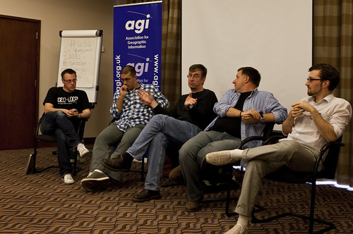
W3G Closing Panel

Attending any sort of conference is a tiring affair; chairing and organising one is truly exhausting. While most of the thanks on the day and afterwards were directed at me, the real thanks needs to go to my fellow organiser, Rollo Home, with the support of Chris Holcroft and Claire Huppertz, all of whom had their hands more than full with GeoCommunity starting the very next day after W3G.

As chair, I gave the opening introduction, to set the theme and tone of the day and to introduce the unconference element to those unfamiliar with the concept.

So should W3G have existed at all? The GeoWeb Track at GeoCommunity 2009 certainly showed that there was an appetite for the neo-geographic side of the Location Industry, so why not integrate W3G or the GeoWeb Track into the main GeoCommunity again? That's a difficult decision to come to ... whilst there was probably around 30% of the audience of W3G attending GeoCommunity, that still leaves 70% of the audience who were totally new to the AGI. Would they have paid the asking price of a GeoCommunity ticket? Probably not. The neo-geography side of things does tend to thrive on free or low cost events (with the notable exception of O'Reilly's Where 2.0 in Silicon Valley, which is both excellent and eye-wateringly expensive). So for this year at least, W3G served a valuable dual purpose, bringing the AGI to the attention of a community which probably didn't know it even existed and allowing a whole load of latent geographers to meet, talk, learn and network ... as well as consuming vast amounts of coffee, beer and curry. In that order.

We're already talking about repeating the success of W3G next year in some shape or form; something I definitely want to be involved in. But I would like to see the gap between the GIS heartland and the neo-geographers, which still seem to be a long way apart at times, narrowed or even closed. The AGI is eminently poised to help bring these two parts of the community together and GeoCommunity 2011 would be the ideal event to do this, making it a Geo Community in the truest sense of the word. In 2009 I questioned whether GeoCommunity would unite the two polarised worlds of geo ... the answer in 2010 is that we've take a few steps in the right direction, but we're still not there yet. Photo Credits: Paul Clarkel on Flickr.

Last year GeoCommunity, the annual conference of Britain's Association for Geographic Information, took the brave (and in my view totally necessary) step of branching out from their traditional GIS heartland audience (sometimes referred to somewhat disparagingly as paleotards) to take on board the views of the neo-geographers, Web 2.0 and LBMS community (sometimes equally disparagingly called neotards). Mud-slinging labels aside, both geographic communities benefitted from the Geo-Web Track as it was called. I was lucky enough to be asked to participate and the Geo-Web Track was a resounding success, for both the paleo-geography and neo-geography camps.

This year, attempting to build on the success of the Geo-Web Track, I was asked by the AGI to chair a one day conference to run on the day before GeoCommunity 2009. Originally pitched as a true unconference I went for an (un)conference, half way between the joyous informality of an unconference and the formality of an invited speaker conference. So we had both, unconference sessions (all of which were filled with ease) and a set of invited guest speakers and keynotes. Trying to think of a name, I came up with W3G ... the 3 W's of Geo, which had cropped up in a blog post in April of this year. Any resemblance in name between W3G and the W3C is, of course, purely intentional.

W3G Closing Panel

Attending any sort of conference is a tiring affair; chairing and organising one is truly exhausting. While most of the thanks on the day and afterwards were directed at me, the real thanks needs to go to my fellow organiser, Rollo Home, with the support of Chris Holcroft and Claire Huppertz, all of whom had their hands more than full with GeoCommunity starting the very next day after W3G.

As chair, I gave the opening introduction, to set the theme and tone of the day and to introduce the unconference element to those unfamiliar with the concept.

So should W3G have existed at all? The GeoWeb Track at GeoCommunity 2009 certainly showed that there was an appetite for the neo-geographic side of the Location Industry, so why not integrate W3G or the GeoWeb Track into the main GeoCommunity again? That's a difficult decision to come to ... whilst there was probably around 30% of the audience of W3G attending GeoCommunity, that still leaves 70% of the audience who were totally new to the AGI. Would they have paid the asking price of a GeoCommunity ticket? Probably not. The neo-geography side of things does tend to thrive on free or low cost events (with the notable exception of O'Reilly's Where 2.0 in Silicon Valley, which is both excellent and eye-wateringly expensive). So for this year at least, W3G served a valuable dual purpose, bringing the AGI to the attention of a community which probably didn't know it even existed and allowing a whole load of latent geographers to meet, talk, learn and network ... as well as consuming vast amounts of coffee, beer and curry. In that order.

We're already talking about repeating the success of W3G next year in some shape or form; something I definitely want to be involved in. But I would like to see the gap between the GIS heartland and the neo-geographers, which still seem to be a long way apart at times, narrowed or even closed. The AGI is eminently poised to help bring these two parts of the community together and GeoCommunity 2011 would be the ideal event to do this, making it a Geo Community in the truest sense of the word. In 2009 I questioned whether GeoCommunity would unite the two polarised worlds of geo ... the answer in 2010 is that we've take a few steps in the right direction, but we're still not there yet. Photo Credits: Paul Clarkel on Flickr.

Crystal Ball Gazing Part 1 - The AGI Foresight Study

several other people with an opinion on matters geo were asked to contribute a paper towards the Association for Geographic Information's 2015 Foresight Study.

The geographic information industry is undergoing radical change. Stimulated by technology and social developments, the balance of power between existing and new players is shifting. Government policy is also undergoing transformation with the publication of the UK Location Strategy, INSPIRE, the Marine & Coastal Access Bill and a new business model for Ordnance Survey. The economic strictures under which the public and private sectors will need to operate, as the UK attempts to handle enormous public debt, are also certain to drive changes in market dynamics.

There can be little doubt that in 5 years the industry will look very different to how it does today.

As the industry association, the Association for Geographic Information (AGI) needs to be sure it can continue to deliver its central mission to serve and represent our current and future members through these changes. In order to do so, we need to better understand what these changes are likely to be and how they will impact the geospatial industry and its customers

Way, way back in the deep dark past, Autumn 2009 to be precise, myself and several other people with an opinion on matters geo were asked to contribute a paper towards the Association for Geographic Information's 2015 Foresight Study.

The geographic information industry is undergoing radical change. Stimulated by technology and social developments, the balance of power between existing and new players is shifting. Government policy is also undergoing transformation with the publication of the UK Location Strategy, INSPIRE, the Marine & Coastal Access Bill and a new business model for Ordnance Survey. The economic strictures under which the public and private sectors will need to operate, as the UK attempts to handle enormous public debt, are also certain to drive changes in market dynamics.

There can be little doubt that in 5 years the industry will look very different to how it does today.

As the industry association, the Association for Geographic Information (AGI) needs to be sure it can continue to deliver its central mission to serve and represent our current and future members through these changes. In order to do so, we need to better understand what these changes are likely to be and how they will impact the geospatial industry and its customers

Which is a nice way of saying that we were asked to look forward 5 years hence and try and predict how the UK geospatial industry would change. I had two issues with this.

Crystal Ball

Firstly, we don't have a terribly good track record for predicting how the future of a given technology will turn out ...

"There's no reason for any individual to have a computer in his home" ... Ken Olsen, founder and CEO of DEC in 1977

... and ...

"I think there is a world market for maybe 5 computers" ...Thomas Watson of IBM in 1943 (apocryphal)

Secondly, I have a slight issue with the phrase geospatial industry which, to my mind at least, conjures up images of people dealing with maps and not the geo industry as a whole, although to be fair, I'm not precisely sure what the geo industry actually covers but it's more than just maps.

Pin the Mustache on '70s Burt Reynolds - Instructions

So rather than not participating I chose to conveniently ignore the spatial specialisation an instead, attempt to play pin the tail on the (geo)donkey instead with the following paper submission:

AGI Foresight Study - Teaching Human Geography to the Internet (Gary Gale) Scribd Edit Photo Credits: pasukaru76 and archiemcphee on Flickr.

Deliciousness: bacon, Protect and Survive, outing the paleotards, Fake Carol and crop circles

two weeks since one of these posts; I've been pretty much conferenced out, with FOWA London taking up a sizeable chunk of last week and the AGI's GeoCommunity mopping up any spare time the week before that.

The hallmark of any successful tech conference is appallingly bad wifi which, despite the best protestations of the conference organisers, always buckles under the strain around 30 minutes into the opening keynote. All of which has meant that my Delicious account has been on a bit of a diet recently, but here's what did make it through the wifi ...* Yet more bacon products make it to market. Most of them are novelty value only but surely there's scope for bacon flavoured mayo, for those moments when the perfect BLT is just out of reach? * Twickenham Fire Station tested its' air raid siren last week and memories of the Protect and Survive public service announcements on British TV at the height of the Cold War came flooding back. * My talk's at the AGI GeoCommunity conference seemed to get people talking; both seriously and somewhat tongue in cheek and I also managed to out the (neogeographer) Geoweb chair as an old school paleogeographer. * The CEO of the company I work for finally managed to achieve the accolade of being faked on Twitter. * And the source of all the crop circles was finally found in a town in the US with a strangely familiar name.

Posted via email from Gary's Posterous

It's been almost two weeks since one of these posts; I've been pretty much conferenced out, with FOWA London taking up a sizeable chunk of last week and the AGI's GeoCommunity mopping up any spare time the week before that.

The hallmark of any successful tech conference is appallingly bad wifi which, despite the best protestations of the conference organisers, always buckles under the strain around 30 minutes into the opening keynote. All of which has meant that my Delicious account has been on a bit of a diet recently, but here's what did make it through the wifi ...* Yet more bacon products make it to market. Most of them are novelty value only but surely there's scope for bacon flavoured mayo, for those moments when the perfect BLT is just out of reach? * Twickenham Fire Station tested its' air raid siren last week and memories of the Protect and Survive public service announcements on British TV at the height of the Cold War came flooding back. * My talk's at the AGI GeoCommunity conference seemed to get people talking; both seriously and somewhat tongue in cheek and I also managed to out the (neogeographer) Geoweb chair as an old school paleogeographer. * The CEO of the company I work for finally managed to achieve the accolade of being faked on Twitter. * And the source of all the crop circles was finally found in a town in the US with a strangely familiar name.

Posted via email from Gary's Posterous

Know Your Place; Adding Geographic Intelligence to your Content

SlideShare.

Day two of the AGI GeoCommunity conference and the conference as a whole has ended. We discussed neogeography, paleogeography and pretty much all points in between, finally agreeing that labels such as these get in the way of the geography itself. I was fortunate enough to have my paper submission accepted and presented a talk on how to Know Your Place at the end of the morning's geoweb track. The paper is reproduced below and the deck that accompanies it is on SlideShare.

Know Your Place; Adding Geographic Intelligence to your Content

Abstract

Yahoo! GeoPlanet exposes a geographic ontology of over six million named places, enabling technologies that join users with with most geographically relevant information possible and forms the heart of the Yahoo! Geo Technologies group's technology platform.

GeoPlanet uses a unique, language neutral identifier for (nearly) all named places around the world. Each place exists within a graph of other places; the relationships between places are categorised by the nature of the relationship, categorised by administrative hierarchy, geographical scope and place type, amongst other. 

GeoPlanet’s geodata repository is exposed by publicly available web service platforms that allow places to be identified within content (Yahoo! Placemaker) and investigated by place name or identifier (Yahoo! GeoPlanet). Users are able to navigate rich metadata associated with a place including the place hierarchies and obtain parent, child, belong-to and neighbouring relationships.

For example, a list of first level administrative entities in a given country may be obtained by requesting the list of the children of that country. In a similar manner the surrounding postal codes of a given post code by be obtained via a request for its neighbours.

The framework for this is uniform and consistent across the globe and facilities geo-enrichment and geo-identification in a wide range of content, both structured and unstructured.

Place-based Thinking

Traditionally geography has been treated as a purely spatial exercise; this is certainly the case on the internet. Places are specified in terms of their longitude and latitude, and so cities or towns are referenced by the co-ordinate pair that identifies the theoretical or arbitrary centre of the place.

From this it can be seen that everything on the internet which is location related is referenced by a co-ordinate pair that has little relevance to a human but much relevance to a geographer or software which can algorithmically undertake a radius search from a point. Instead of a spatially based approach to location, Yahoo! Geo Technologies take a place based approach.

The map above shows a spatially correct map of the central area of the London Underground network similar to those produced up until the early 1930s; in the central area of London the map is compressed due to the close proximity of the lines and their stations.

In 1932 the familiar Tube map, shown below, was produced by Harry Beck in the form of a non geographic linear diagram. Whilst not geographically or spatially correct it is far more accessible and information rich due to Beck’s assumption that people are less concerned with the exact location of a station and more interested in how to change between lines and get to their destination.

We have taken a not dissimilar approach with our repository of named places, where a place can be a monument, a park, a colloquial region such as the Home Counties and continent or even the Earth. We have taken each of these different place names at all of their differing granularities and given them unique identifiers, called Where On Earth Ids.

WOEIDs

The Where On Earth ID is a unique and permanent global identifier, shared publicly via the GeoPlanet and Placemaker API platforms.

They are language neutral, thus the WOEID for London is the same as for Londres, for Londra and for ロンドン, whilst recognising, for the London in the United Kingdom, that London, Central London, Greater London and the City of London are geographically related though separate places.

Their usage ensure that all Yahoo! APIs have the ability to employ geography consistently and globally.

A Global Geographic Ontology

Within our geodata repository we know not only where a place is geographically located, via its centroid, but also how these places relate to each other. This is more than an index of places, it is a geographic ontology of named places, each of which is referenced by a WOEID.Using the postal town of Stratford-upon-Avon as an example, we can determine the children of a place, its parent, its adjacent places and non administrative or colloquial areas that a place belongs to or is contained within, at the following granularities. 

  • Supernames
  • Continents
  • Countries
  • Counties
  • Regions
  • Neighbourhoods
  • ZIP and Postal Codes
  • Custom Geographies

Joining People with Content and Content with People

We can use Placemaker to parse structured and unstructured content and to identify the places referenced, each of which is represented by a WOEID. Where more than one potential place exists for each name, a ranked list of disambiguated names is presented.

Each of the WOEIDs returned by Placemaker have the notional centroid and the bounding box, described by the South West and North East coordinates, as attributes. This allows the concept of a place to be displayed, such as that for the postal town of Stratford-upon-Avon, as shown below.

For each WOEID, we can use GeoPlanet to determine the vertical relationships of the place, such as which cities are in a country or which postal codes are within a city. We can determine the states, provinces or districts with in a country and which countries are on a continent. This powerful vertical hierarchy can be easily navigated from any WOEID.

GeoPlanet also contains a horizontal-like hierarchy, which frequently overlaps. If searching against a specific place such as a postal code, we can determine the surrounding postal codes as well; if searching for a town, we can determine the surrounding postal towns, as shown below.

GeoPlanet contains a rich ontology of named places, which allows us to look up places and where these places are. But more powerful is the relationship between places which allows users of GeoPlanet to add geographic intelligence to their use cases and applications, browsing the horizontal and vertical hierarchies with ease to discover geographic detail that no other point radius-based search would allow us to do.

Capturing the World’s Geography as it is Used by the World’s People 

The Oxford English Dictionary, often criticised for capturing transient or contentious terms, states its goal as “to capture the English language as it is used at this time” and not to impose how things are called. In the same vein, our goal is to capture the world’s geography as it is used by the world’s people.

We aim to follow the United Nations and ISO 3166-1 guidelines on the official name for a place but we strive to know the informal, the ethnic and the colloquial. We are less concerned with imposing a formal geography as we are with describing how a place is described today and what its relationship is with its parent, its children and its neighbours.

Thus we recognise that MOMA NYC (WOEIDs 23617044 and 2459115) is used to refer to the Museum of Modern Art in New York, that San Francisco (2487956) is the more commonly used form of The City and County of San Francisco and that the London Eye and the Millennium Wheel are synonymous (WOEID 22475381).

A Tale of Two Stratfords

Stratford is an important tourist destination, due to the town being William Shakespeare’s birthplace, with both the “on-Avon” and “upon-Avon” suffixes being used to refer to the town. GeoPlanet recognises both Stratford-on-Avon and Stratford-upon-Avon (WOEID 36424) when referring to the postal town and further recognises Stratford-on-Avon (WOEID 12696101) as the administrative District which is the parent for Stratford-upon-Avon.

“the Council often gets asked why there is a difference in using the terms 'Stratford-on-Avon' and 'Stratford-upon-Avon'. Anything to do with the town of Stratford is always referred to as Stratford-upon-Avon. However, as a district council, we cover a much larger area than the town itself, but did not want to lose the instantly recognised tag of Stratford, so anything to do with the district is referred to asStratford-on-Avon.” 

Appendix A - Data Background

The GeoPlanet geodata repository is derived from a variety of sources, both spatial data vendors, openly available sources and Yahoo! sourced. In raw form, it occupies 25 GB of storage; after automated  topology generation and semi automated processing to clean the data and to remove duplicates, the final data footprint is around 9.5 GB. A specialised Editorial team assesses overall data quality and integrity, areas of ambiguity and challenging geographics, such as disputed territories and colloquial areas.

Appendix B - Further Reading

  1. Yahoo! Developer Network - Yahoo! Placemaker
  2. Yahoo! Developer Network - Yahoo! GeoPlanet
  3. The London Tube Map Archive
  4. Transport for London - Design Classic
  5. Yahoo! Developer Network - Where On Earth Identifiers
  6. Oxford English Dictionary - Preface to the Second Edition (1989)
  7. Yahoo! Developer Network - On Naming and Representation
  8. Stratford-on-Avon District Council - Community and Living

Posted via email from Gary's Posterous

Plenaries, Privacy and Place

Location and Privacy - Where Do We Care?

Terry Jones, Audrey Mandela and Ian Broadbent, chaired and overseen by conference chair Steven Feldman. Our location is probably the single most valuable facet of our online identity, although where I currently am, whilst interesting, is far less valuable and  personal than where I've been. Where I've been, if stored, monitored and analysed, provides a level of insight into my real world activities that transcends the other forms of insight and targeting that are directed at my online activities, such as behavioural and demographic analysis.Where I've been, my location stream if you will, is a convergence of online and real world identity and should not be revealed, ignored or given away without thought and without consent.In the real world we unconsciously provide differing levels of granularity in our social engagements when we answer the seemingly trivial question "where have you been?". To our family and close friends we may give a detailed reply ... "I was out with colleagues from work at Browns on St. Martin's Lane, London", to other friends and colleagues we may give a more circumspect reply ... "I was out in the Covent Garden area" and to acquaintances, a more generalised reply ... "I was in Central London" or even "mind your own business"As with the real world, so we should choose to reveal our location to applications and to companies online with differing levels of granularity, including the ability to be our own source of truth and to conceal ourselves entirely, in other words, to lie about where I am. Where I am in the real world should be revealed to the online world only on an opt-in basis, carefully considered and with an eye on the value proposition that is being given to me on the basis of revealing my location to a third party. My location is mine and mine alone and I should never have to opt out of revealing where am I and where I've been. Posted via email from Gary's Posterous

As part of this year's AGI GeoCommunity '09 conference, I took part in the Privacy: Where Do We Care? panel on location and the implications for privacy with Terry Jones, Audrey Mandela and Ian Broadbent, chaired and overseen by conference chair Steven Feldman. Our location is probably the single most valuable facet of our online identity, although where I currently am, whilst interesting, is far less valuable and  personal than where I've been. Where I've been, if stored, monitored and analysed, provides a level of insight into my real world activities that transcends the other forms of insight and targeting that are directed at my online activities, such as behavioural and demographic analysis.Where I've been, my location stream if you will, is a convergence of online and real world identity and should not be revealed, ignored or given away without thought and without consent.In the real world we unconsciously provide differing levels of granularity in our social engagements when we answer the seemingly trivial question "where have you been?". To our family and close friends we may give a detailed reply ... "I was out with colleagues from work at Browns on St. Martin's Lane, London", to other friends and colleagues we may give a more circumspect reply ... "I was out in the Covent Garden area" and to acquaintances, a more generalised reply ... "I was in Central London" or even "mind your own business"As with the real world, so we should choose to reveal our location to applications and to companies online with differing levels of granularity, including the ability to be our own source of truth and to conceal ourselves entirely, in other words, to lie about where I am. Where I am in the real world should be revealed to the online world only on an opt-in basis, carefully considered and with an eye on the value proposition that is being given to me on the basis of revealing my location to a third party. My location is mine and mine alone and I should never have to opt out of revealing where am I and where I've been. Posted via email from Gary's Posterous

The Geo Ice Has Broken

AGI GeoCommunity conference in Stratford-upon-Avon (but not Stratford-upon-Avon, oh no, that's the district not the town you know) and the run up to the conference has started extremely well, with the added bonus for me that John McKerrell of mapme.at used a quote from one of my decks as the #geocom landing page. Twitter is abuzz with commentary on what's happening and who's going to be doing what, all accompanied by the eponymous #geocom hashtag and everyone's hoping that the conference lives up to their expectations. As Thierry Gregorious aptly put it on Twitter "#geocom If this feed is producing messages at current rate, will people be glued to their mobiles instead of the presentations?" ... we shall see.The ice breaker dinner well and truly broke ice and I landed up on a table full of geostrangers and Andrew Turner; as table 24 we put in a rather respectable joint second place in the 100 question quiz, but then crashed and burned to 3rd place after not being nearly accurate enough in the tie-breaker question on when precisely did the Berlin Wall come down.After a surprisingly good dinner, with surprisingly good wine we sat through a surprising, and intriguing, comedienne who appeared to be the result of a union between Jasper Carrot and Victoria Wood. It was certainly an experience.Finally everyone headed to the bar where some overworked and entirely good natured bar staff served us geolibations, geolagulavins and geo-gin-and-tonics until the early hours.And the conference hasn't even begun yet ... Posted via email from Gary's Posterous

Last night was the icebreaker for the AGI GeoCommunity conference in Stratford-upon-Avon (but not Stratford-upon-Avon, oh no, that's the district not the town you know) and the run up to the conference has started extremely well, with the added bonus for me that John McKerrell of mapme.at used a quote from one of my decks as the #geocom landing page. Twitter is abuzz with commentary on what's happening and who's going to be doing what, all accompanied by the eponymous #geocom hashtag and everyone's hoping that the conference lives up to their expectations. As Thierry Gregorious aptly put it on Twitter "#geocom If this feed is producing messages at current rate, will people be glued to their mobiles instead of the presentations?" ... we shall see.The ice breaker dinner well and truly broke ice and I landed up on a table full of geostrangers and Andrew Turner; as table 24 we put in a rather respectable joint second place in the 100 question quiz, but then crashed and burned to 3rd place after not being nearly accurate enough in the tie-breaker question on when precisely did the Berlin Wall come down.After a surprisingly good dinner, with surprisingly good wine we sat through a surprising, and intriguing, comedienne who appeared to be the result of a union between Jasper Carrot and Victoria Wood. It was certainly an experience.Finally everyone headed to the bar where some overworked and entirely good natured bar staff served us geolibations, geolagulavins and geo-gin-and-tonics until the early hours.And the conference hasn't even begun yet ... Posted via email from Gary's Posterous

Is AGI Short for "Ahh, Got (Any) Inspiration"?

So next week is GeoCommunity '09, the annual conference for the Association of Geographic Information and everyone's getting thoroughly excited at the prospect of putting the word "geo" in front of everything, including georant, geobeer (although only in half measures for some reason), geochat and conference chair Steven Feldman's personal favourite, geolagavulin.

This probably won't be news to a lot of people as I've written about it on my personal blog as well as the Yahoo! Geo Technologies one and I'll be there as well. I may have overstretched myself a little bit though as I'm now just about drained of inspiration. On the Wednesday, I'm on the "Privacy; where do we care?" panel from 4.00 PM onwards taking a pro location sharing, pro opting in and pro privacy controls position and then I'll be loitering around Speaker's Corner, or the bar as it's more commonly known, for the Soapbox sessions where I'll be georanting about "Neo this and paleo that ... it's all just Geo" before beating a hasty retreat back to the bar to seek solace in a geobeer. Then on the Thursday, I'll be on the Geoweb track and giving a talk to accompany my "Know Your Place; Adding Geographic Intelligence to your Content" paper. Snappy title that, but nowhere near as snappy as Martin Daly's talk on "Human Sacrifice, Dogs and Cats Living Together and Mass Hysteria", which deserves an award for title alone. I'll be blogging about all of this geomadness here, be updating and throwing quotes around on Twitter via the usual @vicchi account with the official #geocom hashtag and lurking in the back of the conference rooms looking for power to replenish my laptop which will have been justifiably drained with all this geosocial networking activity. Posted via email from Gary's Posterous

GeoCommunity '09 - Bridging the Gap between the GIS and Neogeo Worlds?

It's probably an oversimplification of a complex issue but geographic conferences or events can be somewhat polarised towards one of two extremes. On the one hand you have the solid, slightly reassuring and established GIS world whilst on the other we have the upstart, slightly shouty, web-centric neogeography community. These two worlds don't always co-exist particularly well and each can be equally distrustful of the other. Where 2.0 in the US tries valiantly to get these two worlds to talk to one another and to share a stage but it doesn't always work well; the GIS community brandish their desktop GIS system while the neogeo hackers point to their PHP based web mashups.

But this year in Stratford-upon-Avon something brave, intriguing and altogether worthwhile is happening; both communities are being represented at the AGI's GeoCommunity '09 conference, which takes place in a little over two and half weeks time. Yes, there's GIS practitioners and yes, there's neogeo developers but there's also speakers covering all points inbetween; just take a look at the PDF of programme for this year. Even the tag line for the conference, Realising the Value of Place, places emphasis on the meeting of the geo-worlds.

AGI GeoCommunity '09 - 'Realising the Value of Place' September 23rd - 24th 2009, Holiday Inn, Stratford-upon-Avon, UK True, the big names and the big players of the overall geo community are well represented; Yahoo!, Google, Microsoft, ESRI, Pitney Bowes MapInfo, Ordnance Survey and I'm fortunate enough to be representing Yahoo! Geo Technologies on the second day but take a closer look. John McKerrell of mapme.at is speaking, so's Andy Allan on OpenCycleMapTom Taylor is talking about neighbourhood boundaries and Terry Jones will be making us all location aware by using FluidDB, plus keynotes from Andrew Turner and from Peter Batty. This is a staggering and diverse cross section of the entire geo-community and Steven Feldman, this year's conference chair and Chris Osborne, from London's #geomob, is behind the geoweb track of sessions, deserve recognition for being able to bring this all together; you can find out more at Steven's and  Chris's respective blogs. It's going to be a geo-tastic conference and I'm looking forward to seeing the usual geo-suspects as well as meeting new friends and colleagues; see you all there.

Posted via email from Gary's Posterous