Posts about ifttt

This Interactive Sandbox Allows Users to Make Topographical Maps in Real-Time

Water moves in predictable ways across undulating landscapes, but it can be hard to appreciate from a human perspective on the ground. It’s much easier to understand when you’re essentially a giant hovering over the land with the ability to move mountains and make rain.

Found at https://www.atlasobscura.com/articles/make-topographical-maps-in-a-sandbox
Today's maps found on the interwebs.

Water moves in predictable ways across undulating landscapes, but it can be hard to appreciate from a human perspective on the ground. It’s much easier to understand when you’re essentially a giant hovering over the land with the ability to move mountains and make rain.

Found at https://www.atlasobscura.com/articles/make-topographical-maps-in-a-sandbox
How to find your home on Pangea

Before there were the continents, there was Pangea. Two hundred million years ago, the enormous land mass began to break apart and we’ve been separated ever since — but a map tool can help you find where a given town would have been on the supercontinent.

Found at https://www.theverge.com/2018/6/17/17467686/map-pangea-earth-antipodes-science-history-tools

Today's maps found on the interwebs.

Before there were the continents, there was Pangea. Two hundred million years ago, the enormous land mass began to break apart and we’ve been separated ever since — but a map tool can help you find where a given town would have been on the supercontinent.

Found at https://www.theverge.com/2018/6/17/17467686/map-pangea-earth-antipodes-science-history-tools

Mapping How Shakespeare Saw the World

The first modern atlas was created in the late 16th century, and was called Theater of the World. It included more than 50 pages of maps of places around the world, which Dutch cartographer Abraham Ortelius likened to a stage where human life played out

Found at https://www.citylab.com/design/2016/09/mapping-how-shakespeare-saw-the-world/500786/

Today's maps found on the interwebs.

The first modern atlas was created in the late 16th century, and was called Theater of the World. It included more than 50 pages of maps of places around the world, which Dutch cartographer Abraham Ortelius likened to a stage where human life played out

Found at https://www.citylab.com/design/2016/09/mapping-how-shakespeare-saw-the-world/500786/

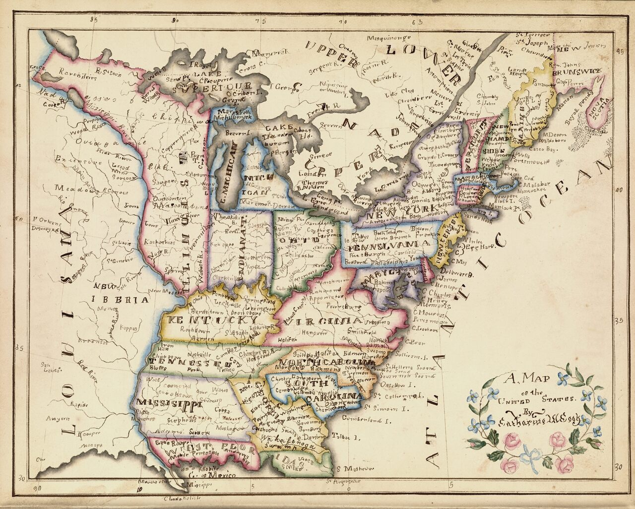
In Its First Decades, The United States Nurtured Schoolgirl Mapmakers

The first “schoolgirl map” that caught historian Susan Schulten’s attention was made in 1823 by Frances Henshaw, a student at one of the best schools for girls in the young United States.

Found at https://www.atlasobscura.com/articles/early-american-schoolgirl-maps

Today's maps found on the interwebs.

The first “schoolgirl map” that caught historian Susan Schulten’s attention was made in 1823 by Frances Henshaw, a student at one of the best schools for girls in the young United States.

Found at https://www.atlasobscura.com/articles/early-american-schoolgirl-maps

How the U.S. Maps the World's Most Disputed Territories | WIRED

How the U.S. Maps the World’s Most Disputed Territories When the United States decides to recognize a new government, or an existing country changes its name, Leo Dillon and his team at the State Department spring into action.

Found at https://www.wired.com/2014/01/state-department-maps/?cid=co17535794

Today's maps found on the interwebs.

How the U.S. Maps the World’s Most Disputed Territories When the United States decides to recognize a new government, or an existing country changes its name, Leo Dillon and his team at the State Department spring into action.

Found at https://www.wired.com/2014/01/state-department-maps/?cid=co17535794

Tokelau: The World's One True Online Superpower

Today's maps found on the interwebs.

This is a map of the online world. Each country is resized for the popularity of its domain name. Lots of weird stuff going on, but the eye is immediately drawn to the map's greatest anomaly: Tokelau. That Pacific island nation is the online world's only true superpower.

Found at https://bigthink.com/strange-maps/tokelau-the-worlds-online-superpower

A cool retro map of USA song titles

This vintage-style map of the USA puts the titles of songs that mention place names onto their corresponding geographical spot. So, for example, the Beasties Boys' "No Sleep Till Brooklyn" is placed right on top of Brooklyn.

Found at https://boingboing.net/2018/11/10/a-cool-retro-map-of-usa-song-t.html

Today's maps found on the interwebs.

This vintage-style map of the USA puts the titles of songs that mention place names onto their corresponding geographical spot. So, for example, the Beasties Boys' "No Sleep Till Brooklyn" is placed right on top of Brooklyn.

Found at https://boingboing.net/2018/11/10/a-cool-retro-map-of-usa-song-t.html

A Map of Every Building in America

Most of the time, The New York Times asks you to read something. Today we are inviting you, simply, to look. On this page you will find maps showing almost every building in the United States.

Found at https://www.nytimes.com/interactive/2018/10/12/us/map-of-every-building-in-the-united-states.html

Today's maps found on the interwebs.

Most of the time, The New York Times asks you to read something. Today we are inviting you, simply, to look. On this page you will find maps showing almost every building in the United States.

Found at https://www.nytimes.com/interactive/2018/10/12/us/map-of-every-building-in-the-united-states.html

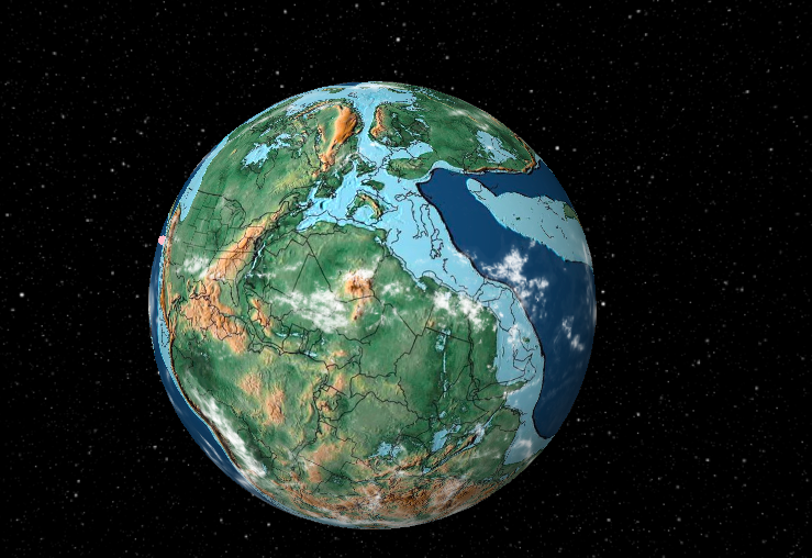
Ancient Earth Globe: see what the world looked like from space in the age of the dinosaurs

The Ancient Earth Globe is an interactive 3D globe that depics the Earth at various points in geological history from 750m years ago until now. Here it is 300m years ago. Late Carboniferous. Plants developed root systems that allowed them to grow larger and move inland.

Found at https://boingboing.net/2018/08/06/ancient-earth-globe-see-what.html

Today's maps found on the interwebs.

The Ancient Earth Globe is an interactive 3D globe that depics the Earth at various points in geological history from 750m years ago until now. Here it is 300m years ago. Late Carboniferous. Plants developed root systems that allowed them to grow larger and move inland.

Found at https://boingboing.net/2018/08/06/ancient-earth-globe-see-what.html

Find the other side of the world from anywhere in the world

Antipodr is a nifty little site that lets visitors learn what's on the opposite side of the globe from any coordinate. For instance, Auckland, New Zealand is directly opposite Venta de Leche in southern Spain. Honolulu, Hawai'i is directly opposite Dekar in Botswana.

Found at https://boingboing.net/2018/08/06/find-the-other-side-of-the-wor.html

Today's maps found on the interwebs.

Antipodr is a nifty little site that lets visitors learn what's on the opposite side of the globe from any coordinate. For instance, Auckland, New Zealand is directly opposite Venta de Leche in southern Spain. Honolulu, Hawai'i is directly opposite Dekar in Botswana.

Found at https://boingboing.net/2018/08/06/find-the-other-side-of-the-wor.html

If Google Maps says a place has a certain name, it now has that name

The East Cut is a neighborhood in San Francisco invented by a branding agency. Such things usually wither on the local-business bullshit vine, but thanks to Google Maps, it's now the plain reality of that part of town.

Found at https://boingboing.net/2018/08/02/if-google-maps-says-a-place-ha.html

Today's maps found on the interwebs.

The East Cut is a neighborhood in San Francisco invented by a branding agency. Such things usually wither on the local-business bullshit vine, but thanks to Google Maps, it's now the plain reality of that part of town.

Found at https://boingboing.net/2018/08/02/if-google-maps-says-a-place-ha.html

Climate change brings the UK’s hidden past to the surface

In southern Wales’ Vale of Glamorgan, archaeologists flying over a prehistoric settlement they had previously studied got a surprise: the ghostly outline of a Roman villa on the ground inside the older settlement’s boundaries.

Found at https://arstechnica.com/science/2018/08/climate-change-brings-the-uks-hidden-past-to-the-surface/

Today's maps found on the interwebs.

In southern Wales’ Vale of Glamorgan, archaeologists flying over a prehistoric settlement they had previously studied got a surprise: the ghostly outline of a Roman villa on the ground inside the older settlement’s boundaries.

Found at https://arstechnica.com/science/2018/08/climate-change-brings-the-uks-hidden-past-to-the-surface/

Fascinating look at how America uses its land

Bloomberg has an interactive report that shows how America uses its land for different purposes. I was surprised by how much land is dedicated to livestock pasture: 41%. Also the 100 largest landowning families own land equal to the size of Florida.

Found at https://boingboing.net/2018/08/01/fascinating-look-at-how-americ.html

Today's maps found on the interwebs.

Bloomberg has an interactive report that shows how America uses its land for different purposes. I was surprised by how much land is dedicated to livestock pasture: 41%. Also the 100 largest landowning families own land equal to the size of Florida.

Found at https://boingboing.net/2018/08/01/fascinating-look-at-how-americ.html

NASA's infrared map of Titan

Composed from 13 years of Cassini probe mission data, NASA's infrared-based map of Titan shows off one of the solar system's most promising worlds.

Found at https://boingboing.net/2018/07/19/nasas-infrared-map-of-titan.html

Today's maps found on the interwebs.

Composed from 13 years of Cassini probe mission data, NASA's infrared-based map of Titan shows off one of the solar system's most promising worlds.

Found at https://boingboing.net/2018/07/19/nasas-infrared-map-of-titan.html

If an algorithm draws lines on a map, is that the same as land surveying?

When does drawing a digital line on a satellite map cross an ethereal threshold into the centuries-old practice of licensed land surveying? This is the existential question now before a Mississippi state court.

Found at https://arstechnica.com/tech-policy/2018/07/if-an-algorithm-draws-lines-on-a-map-is-that-the-same-as-land-surveying/

Today's maps found on the interwebs.

When does drawing a digital line on a satellite map cross an ethereal threshold into the centuries-old practice of licensed land surveying? This is the existential question now before a Mississippi state court.

Found at https://arstechnica.com/tech-policy/2018/07/if-an-algorithm-draws-lines-on-a-map-is-that-the-same-as-land-surveying/

Check out these gorgeous edible earths

Dutch pastry/dessert chef Daniel Jongsma created this beautiful confection that looks like earth, replete with continents and clouds. Day 5 of the #7dayschallenge where i was invited by @robin_hoedjes here's to share my showpiece during the dutch chocolate masters in 2010.

Found at https://boingboing.net/2018/07/02/check-out-these-gorgeous-edibl.html

Today's maps found on the interwebs.

Dutch pastry/dessert chef Daniel Jongsma created this beautiful confection that looks like earth, replete with continents and clouds. Day 5 of the #7dayschallenge where i was invited by @robin_hoedjes here's to share my showpiece during the dutch chocolate masters in 2010.

Found at https://boingboing.net/2018/07/02/check-out-these-gorgeous-edibl.html

Cool satellite view of dozens of oxbow lakes formed when a river changed course

When a river changes course on its flood plain, it can leave an entire bend of the river cut off from the new flow, forming an oxbow lake. Seen in bright blue in this shot of the Songhua River in northeast China, they are usually narrow crescents.

Found at https://boingboing.net/2018/06/26/cool-satellite-view-of-dozens.html

Today's maps found on the interwebs.

When a river changes course on its flood plain, it can leave an entire bend of the river cut off from the new flow, forming an oxbow lake. Seen in bright blue in this shot of the Songhua River in northeast China, they are usually narrow crescents.

Found at https://boingboing.net/2018/06/26/cool-satellite-view-of-dozens.html

Someone drew the Tube map on an aerial photo of London and it's totally mesmerising

When you take a photo from an airplane, the last thing you'd expect is for a complete and utter stranger to draw a load of squiggly lines over it. But, then again, the internet never fails to defy our expectations. 

Found at https://mashable.com/2018/06/26/aerial-photo-london-tube/

Today's maps found on the interwebs.

When you take a photo from an airplane, the last thing you'd expect is for a complete and utter stranger to draw a load of squiggly lines over it. But, then again, the internet never fails to defy our expectations. 

Found at https://mashable.com/2018/06/26/aerial-photo-london-tube/

What the world would be like if land and sea were inverted

You've likely seen maps of the earth with land and sea inverted, where Asia becomes the world's greatest ocean and the Pacific a vast, sprawling continent. But high school geography teacher John M Adams took it a step further and explained what it would be like to live in this parallel world.

Found at https://boingboing.net/2018/06/11/what-the-world-would-be-like-i.html

Today's maps found on the interwebs.

You've likely seen maps of the earth with land and sea inverted, where Asia becomes the world's greatest ocean and the Pacific a vast, sprawling continent. But high school geography teacher John M Adams took it a step further and explained what it would be like to live in this parallel world.

Found at https://boingboing.net/2018/06/11/what-the-world-would-be-like-i.html

Kilauea's new lava flow can be seen from space

The small but bright fissure at the left edge of Kilauea's lava field can already be seen from space via infrared imaging, but it's dwarfed by the magnitude of previously existing flows.

Found at https://boingboing.net/2018/06/04/kilaueas-new-lava-flow-can-b.html

Today's maps found on the interwebs.

The small but bright fissure at the left edge of Kilauea's lava field can already be seen from space via infrared imaging, but it's dwarfed by the magnitude of previously existing flows.

Found at https://boingboing.net/2018/06/04/kilaueas-new-lava-flow-can-b.html

Map of Britain's roads... and nothing else

jamaps created a map that shows all the main roads in Britain and nothing else, giving the vague impression of something weirdly biological.

Found at https://boingboing.net/2018/05/30/map-of-britains-roads-and.html

Today's maps found on the interwebs.

jamaps created a map that shows all the main roads in Britain and nothing else, giving the vague impression of something weirdly biological.

Found at https://boingboing.net/2018/05/30/map-of-britains-roads-and.html

New Zealand's so sick of being left off maps they've launched an entire ad campaign

New Zealand is continually omitted from maps of the world. Seriously, there's an entire Reddit thread highlighting examples of the country being completely wiped from global existence. 

Found at https://mashable.com/2018/05/01/get-new-zealand-on-the-map/

Today's maps found on the interwebs.

New Zealand is continually omitted from maps of the world. Seriously, there's an entire Reddit thread highlighting examples of the country being completely wiped from global existence. 

Found at https://mashable.com/2018/05/01/get-new-zealand-on-the-map/

A new map of Great Britain.

Lionel Pincus and Princess Firyal Map Division, The New York Public Library. "A new map of Great Britain." The New York Public Library Digital Collections. 1736. https://ift.tt/2HTr3Yo

Found at https://digitalcollections.nypl.org/items/510d47e4-5230-a3d9-e040-e00a18064a99

Today's maps found on the interwebs.

Lionel Pincus and Princess Firyal Map Division, The New York Public Library. "A new map of Great Britain." The New York Public Library Digital Collections. 1736. https://ift.tt/2HTr3Yo

Found at https://digitalcollections.nypl.org/items/510d47e4-5230-a3d9-e040-e00a18064a99

The first printed map of the world will be auctioned for up to £60,000 this month

Nowadays most of us resort to our smartphones and Google Maps to help navigate us around unfamiliar places. But things were a little different for some of the world’s first explorers who used printed maps and atlases to guide them.

Found at https://www.housebeautiful.com/uk/lifestyle/a20115850/sothebys-auction-ancient-maps/

Today's maps found on the interwebs.

Nowadays most of us resort to our smartphones and Google Maps to help navigate us around unfamiliar places. But things were a little different for some of the world’s first explorers who used printed maps and atlases to guide them.

Found at https://www.housebeautiful.com/uk/lifestyle/a20115850/sothebys-auction-ancient-maps/

A geographically correct map of the state of Texas

Title A geographically correct map of the state of Texas Additional title: Texas, the empire state of the great southwest Names Texas & Pacific Railway (Publisher) Collection Dates / Origin Date Issued: 1876 (Inferred) Place: Marshall, TX Publisher: Texas and Pacific Railway Company Library loc

Found at https://digitalcollections.nypl.org/items/7c49dc40-d2fe-0135-b8cb-45b777ad6911

Today's maps found on the interwebs.

Title A geographically correct map of the state of Texas Additional title: Texas, the empire state of the great southwest Names Texas & Pacific Railway (Publisher) Collection Dates / Origin Date Issued: 1876 (Inferred) Place: Marshall, TX Publisher: Texas and Pacific Railway Company Library loc

Found at https://digitalcollections.nypl.org/items/7c49dc40-d2fe-0135-b8cb-45b777ad6911

How many Switzerlands fits in Brazil [1100x1100]

There's 142 Switzerlands there, since no one put the number in the comments. And, since Switzerland's area is 41,285 km 2 and Brazil's 8,515,767 km2, it's actually a little over 206 times larger.

Found at https://www.reddit.com/r/MapPorn/comments/8ee90c/how_many_switzerlands_fits_in_brazil_1100x1100/

Today's maps found on the interwebs.

There's 142 Switzerlands there, since no one put the number in the comments. And, since Switzerland's area is 41,285 km 2 and Brazil's 8,515,767 km2, it's actually a little over 206 times larger.

Found at https://www.reddit.com/r/MapPorn/comments/8ee90c/how_many_switzerlands_fits_in_brazil_1100x1100/

Mapping Antwerp’s Last ‘Invisible Route’

Late last year, Maarten Inghels of Antwerp, Belgium, was reading the paper when a news story caught his attention. Yet another camera system was about to be installed in the city, he read. Not only that, this particular system was smart, an active rather than passive watcher.

Found at https://www.atlasobscura.com/articles/antwerp-invisible-route-map-surveillance-cameras

Today's maps found on the interwebs.

Late last year, Maarten Inghels of Antwerp, Belgium, was reading the paper when a news story caught his attention. Yet another camera system was about to be installed in the city, he read. Not only that, this particular system was smart, an active rather than passive watcher.

Found at https://www.atlasobscura.com/articles/antwerp-invisible-route-map-surveillance-cameras

Map of how England and Wales is aging

Outside the big cities, England and Wales is aging. From Plumplot: In 2002, 40% of the population was over 44 years old. Fourteen years later it was 43.5%. The share almost equaled to the population below 35, which was 43.7%. Life expectancy also increased.

Found at https://boingboing.net/2018/04/16/map-of-how-england-and-wales-i.html

Today's maps found on the interwebs.

Outside the big cities, England and Wales is aging. From Plumplot: In 2002, 40% of the population was over 44 years old. Fourteen years later it was 43.5%. The share almost equaled to the population below 35, which was 43.7%. Life expectancy also increased.

Found at https://boingboing.net/2018/04/16/map-of-how-england-and-wales-i.html

Too many cars, too few supermarkets: how Australia's cities really stack up

With five cities in the top 20 of the Economist Intelligence Unit’s annual global liveability survey, Australia boasts some of the most attractive urban environments in the world.

Found at https://www.theguardian.com/cities/2018/apr/10/too-many-cars-too-few-supermarkets-how-australias-cities-really-stack-up-liveable

Today's maps found on the interwebs.

With five cities in the top 20 of the Economist Intelligence Unit’s annual global liveability survey, Australia boasts some of the most attractive urban environments in the world.

Found at https://www.theguardian.com/cities/2018/apr/10/too-many-cars-too-few-supermarkets-how-australias-cities-really-stack-up-liveable

Didcot signs point to Narnia, Gotham City and Middle Earth

Fictional worlds such as Narnia, Gotham City and Neverland have mysteriously appeared on road signs in Oxfordshire. The roundabout signs in Didcot - described as England's most normal town - also direct drivers to Middle Earth and Emerald City.

Found at https://www.bbc.co.uk/news/uk-england-oxfordshire-43459598

Today's maps found on the interwebs.

Fictional worlds such as Narnia, Gotham City and Neverland have mysteriously appeared on road signs in Oxfordshire. The roundabout signs in Didcot - described as England's most normal town - also direct drivers to Middle Earth and Emerald City.

Found at https://www.bbc.co.uk/news/uk-england-oxfordshire-43459598

One-person-one-dot maps and how to make them

A couple of days ago, one of my favorite cartographers, Esri’s John Nelson declared his love for dot density maps. I like dot density maps too, but never really thought through why.

Found at https://www.maartenlambrechts.com/2018/02/13/one-person-one-dot-maps-and-how-to-make-them.html

Today's maps found on the interwebs.

A couple of days ago, one of my favorite cartographers, Esri’s John Nelson declared his love for dot density maps. I like dot density maps too, but never really thought through why.

Found at https://www.maartenlambrechts.com/2018/02/13/one-person-one-dot-maps-and-how-to-make-them.html

Fortresses, farmlands of the Maya emerge from massive LiDAR survey

A recent aerial survey revealed thousands of ancient Maya structures previously hidden beneath the dense Guatemalan jungle, including houses, irrigation canals, fortifications, and even a pyramid.

Found at https://arstechnica.com/science/2018/02/lasers-shed-some-light-on-the-maya-snake-kingdom/

Today's maps found on the interwebs.

A recent aerial survey revealed thousands of ancient Maya structures previously hidden beneath the dense Guatemalan jungle, including houses, irrigation canals, fortifications, and even a pyramid.

Found at https://arstechnica.com/science/2018/02/lasers-shed-some-light-on-the-maya-snake-kingdom/

An artist is reimagining England’s national parks in the style of J.R.R. Tolkien’s maps

J.R.R. Tolkien’s The Lord of the Rings and The Hobbit are iconic fantasy adventures, and readers return to them time and again because of the rich detail that defines the world.

Found at https://www.theverge.com/2018/2/4/16959406/j-r-r-tolkien-maps-middle-earth-england-national-parks-dan-bell-art

Today's maps found on the interwebs.

J.R.R. Tolkien’s The Lord of the Rings and The Hobbit are iconic fantasy adventures, and readers return to them time and again because of the rich detail that defines the world.

Found at https://www.theverge.com/2018/2/4/16959406/j-r-r-tolkien-maps-middle-earth-england-national-parks-dan-bell-art

This incredible map shows the undersea cables that keep the internet alive — and security services are worried Russia could cut them

It shows the sheer scale of the infrastructure which keeps the internet running. It's built up over decades, mainly as a result of private enterprise rather than coordinated state infrastructure projects, like road or water networks.

Found at https://www.businessinsider.com/map-shows-extent-of-undersea-internet-cables-that-russians-could-cut-2017-12

Today's maps found on the interwebs.

It shows the sheer scale of the infrastructure which keeps the internet running. It's built up over decades, mainly as a result of private enterprise rather than coordinated state infrastructure projects, like road or water networks.

Found at https://www.businessinsider.com/map-shows-extent-of-undersea-internet-cables-that-russians-could-cut-2017-12

World’s Largest 16th-Century Map Digitally Re-Assembled at Stanford University

Save this picture! Stanford University experts digitally assembled what is considered the largest world map produced in the 16th-century.

Found at https://www.archdaily.com/887464/worlds-largest-16th-century-map-digitally-re-assembled-at-stanford-university

Today's maps found on the interwebs.

Save this picture! Stanford University experts digitally assembled what is considered the largest world map produced in the 16th-century.

Found at https://www.archdaily.com/887464/worlds-largest-16th-century-map-digitally-re-assembled-at-stanford-university

Charting the Geography of Classic Literature

How do you map the hunt for a fictional creature in a nonsensical poem? If you’re Lewis Carroll, author of The Hunting of the Snark and, of course, Alice’s Adventures in Wonderland, you create a map devoid of meaning: just white space, a few notations, and the points of the compass.

Found at https://www.atlasobscura.com/articles/mapping-literary-worlds

Today's maps found on the interwebs.

How do you map the hunt for a fictional creature in a nonsensical poem? If you’re Lewis Carroll, author of The Hunting of the Snark and, of course, Alice’s Adventures in Wonderland, you create a map devoid of meaning: just white space, a few notations, and the points of the compass.

Found at https://www.atlasobscura.com/articles/mapping-literary-worlds

European history and population mapped by year

Cottereau: This video shows the borders and populations of each country in Europe, for every year since 400 BC. Vassal states and colonies are not included in the count of a country's population." What a mess! One thing I learned is how sparsely-populated Britain was in the Roman age.

Found at https://boingboing.net/2018/01/30/european-history-and-populatio.html

Today's maps found on the interwebs.

Cottereau: This video shows the borders and populations of each country in Europe, for every year since 400 BC. Vassal states and colonies are not included in the count of a country's population." What a mess! One thing I learned is how sparsely-populated Britain was in the Roman age.

Found at https://boingboing.net/2018/01/30/european-history-and-populatio.html

Pennsylvania’s gerrymandered House map was just struck down — with huge implications for 2018

The Pennsylvania Supreme Court ruled Monday that the state’s US House maps were based on a Republican partisan gerrymander that violated the state’s constitution — and struck them down.

Found at https://www.vox.com/2018/1/22/16920636/pennsylvania-gerrymander-ruling-house

Today's maps found on the interwebs.

The Pennsylvania Supreme Court ruled Monday that the state’s US House maps were based on a Republican partisan gerrymander that violated the state’s constitution — and struck them down.

Found at https://www.vox.com/2018/1/22/16920636/pennsylvania-gerrymander-ruling-house

A Map That Celebrates the Subway

Today's maps found on the interwebs.

Starting with London’s Tube, a new series aims to capture the art and history of rapid transit systems around the world. Blue Crow Media, an independent map publisher, recently released their first in a series of public transit maps: a double-sided, cartographic guide of the London Tube.

Found at https://ift.tt/2zBDYu8

Restoring one of the world’s rarest maps

In 1663, Europeans called Australia ‘New Holland’, New Zealand was considered one land mass and Tasmania had only been sighted by Abel Tasman – it would be another hundred years before Europeans would set foot there.

Found at https://ift.tt/2lUUD9s

Today's maps found on the interwebs.

In 1663, Europeans called Australia ‘New Holland’, New Zealand was considered one land mass and Tasmania had only been sighted by Abel Tasman – it would be another hundred years before Europeans would set foot there.

Found at https://ift.tt/2lUUD9s

1934 Map Resizes the World to Show Which Country Drinks the Most Tea

Not a day goes by that I don’t use Google Maps for something or other, whether it’s basic navigation, researching an address, or finding a dry cleaner. Though some of us might resent the dominance such mapping technology has over our daily interactions, there’s no denying its endless utility.

Found at https://ift.tt/2je0DFQ

Today's maps found on the interwebs.

Not a day goes by that I don’t use Google Maps for something or other, whether it’s basic navigation, researching an address, or finding a dry cleaner. Though some of us might resent the dominance such mapping technology has over our daily interactions, there’s no denying its endless utility.

Found at https://ift.tt/2je0DFQ

The country that keeps getting left off maps

New Zealanders fed up with their country being left off of world maps set up a Reddit group to share their exasperation. The 27,000 subscribers of "Maps Without NZ" post pictures of the world with the island nation left off.

Found at https://ift.tt/2zyto9W

Today's maps found on the interwebs.

New Zealanders fed up with their country being left off of world maps set up a Reddit group to share their exasperation. The 27,000 subscribers of "Maps Without NZ" post pictures of the world with the island nation left off.

Found at https://ift.tt/2zyto9W

On This Fourth-Century Map, All Roads Really Do Lead to Rome

Although it resembles nothing like the clear outline of a modern map of the region, the Peutinger Table is a snapshot of how Romans viewed their world, one in which they were at the center.

Found at https://ift.tt/2xjdf6Y

Today's maps found on the interwebs.

Although it resembles nothing like the clear outline of a modern map of the region, the Peutinger Table is a snapshot of how Romans viewed their world, one in which they were at the center.

Found at https://ift.tt/2xjdf6Y

Map: Airport delays in major U.S. cities

Today's maps found on the interwebs.

Forty airports including San Francisco and San Jose are included on the map of delays updated by the Federal Aviation Administration’s Air Traffic Control System Command Center. The status indicates general airport conditions, usually as affected by weather, rather than individual flights.

Found at https://ift.tt/2zX8VZy

This incredible map tool reveals just how much the Mercator map distorts the world

A lot of people have problems with the Mercator map of the world. Fortunately, The True Size is set up to help cartography fans see how much it distorts land mass by allowing users to move outlines of nations across the 2-D images. It is oddly addictive.

Found at https://ift.tt/2xOhrJw

Today's maps found on the interwebs.

A lot of people have problems with the Mercator map of the world. Fortunately, The True Size is set up to help cartography fans see how much it distorts land mass by allowing users to move outlines of nations across the 2-D images. It is oddly addictive.

Found at https://ift.tt/2xOhrJw

If the World Was Mapped Using the Manhattan Grid System

In 1976, Saul Steinberg drew View of the World from 9th Avenue, an illustration that became perhaps the most famous magazine cover in the history of The New Yorker.

Found at https://ift.tt/2h3wgom

Today's maps found on the interwebs.

In 1976, Saul Steinberg drew View of the World from 9th Avenue, an illustration that became perhaps the most famous magazine cover in the history of The New Yorker.

Found at https://ift.tt/2h3wgom

Salt Lake City Transit Map

Today's maps found on the interwebs.

A great old map of transit from Salt Lake City, showing bus lines (in green), trolleybus lines (in red, and curiously referred to as “electric coaches”, a designation that only seems to have been used here), and the one last remaining streetcar line (in blue).

Found at https://ift.tt/2zWMSmy

Scientists release an “Atlas of the Underworld”

Last week, scientists released a monumental interactive catalog that tracks 94 ancient tectonic plates lurking deep within Earth’s mantle, a resource they’re calling an “Atlas of the Underworld.

Found at https://ift.tt/2zy4fdh

Today's maps found on the interwebs.

Last week, scientists released a monumental interactive catalog that tracks 94 ancient tectonic plates lurking deep within Earth’s mantle, a resource they’re calling an “Atlas of the Underworld.

Found at https://ift.tt/2zy4fdh

Hundreds of mysterious stone structures discovered on edge of ancient volcanoes in Saudi Arabia

Hundreds of mysterious structures have been discovered on ancient lava domes in Saudi Arabia by an archaeologist using Google Earth. But the structures found by Mr Kennedy are unlike any before them.

Found at https://ift.tt/2yspsrp

Today's maps found on the interwebs.

Hundreds of mysterious structures have been discovered on ancient lava domes in Saudi Arabia by an archaeologist using Google Earth. But the structures found by Mr Kennedy are unlike any before them.

Found at https://ift.tt/2yspsrp

Computer-generated maps imagine America redivided into equal-population areas

America votes Democrat but elects Republicans, and it's all thanks to how the country is divided up. Even if gerrymandering dies in court, Americans must still live with the the plain fact that every state gets the same number of senators. But what if things were different?

Found at https://ift.tt/2zvLo2z

Today's maps found on the interwebs.

America votes Democrat but elects Republicans, and it's all thanks to how the country is divided up. Even if gerrymandering dies in court, Americans must still live with the the plain fact that every state gets the same number of senators. But what if things were different?

Found at https://ift.tt/2zvLo2z

The Soviet Union Secretly Mapped London... Here Are Those Maps

After the Soviet Union crumbled in the early 1990s, something altogether eerie was discovered. Hundreds and thousand of maps of countries and cities throughout the world had been drawn up by Soviet cartographers, and annotated — often in exacting detail — using Cyrillic script.

Found at https://ift.tt/2zuiBv0

Today's maps found on the interwebs.

After the Soviet Union crumbled in the early 1990s, something altogether eerie was discovered. Hundreds and thousand of maps of countries and cities throughout the world had been drawn up by Soviet cartographers, and annotated — often in exacting detail — using Cyrillic script.

Found at https://ift.tt/2zuiBv0

Mapping Reformation Europe

Maps convey simple historical narratives very clearly–but how useful are simple stories about the past? Many history textbooks and studies of the Reformation include some sort of map that claims to depict Europe’s religious divisions in the sixteenth century.

Found at https://ift.tt/2hKxuVD

Today's maps found on the interwebs.

Maps convey simple historical narratives very clearly–but how useful are simple stories about the past? Many history textbooks and studies of the Reformation include some sort of map that claims to depict Europe’s religious divisions in the sixteenth century.

Found at https://ift.tt/2hKxuVD

London's Hidden Tunnels Revealed In Amazing Cutaways

The layout of London can only be fully understood if we examine it in three dimensions. Tim Dunn takes a look at some of the capital's greatest cutaway diagrams. Our city is a fascinating, infuriating, terrifying, beautiful place.

Found at https://ift.tt/2gjSf72

Today's maps found on the interwebs.

The layout of London can only be fully understood if we examine it in three dimensions. Tim Dunn takes a look at some of the capital's greatest cutaway diagrams. Our city is a fascinating, infuriating, terrifying, beautiful place.

Found at https://ift.tt/2gjSf72

Map of separatist support in Europe

"What about an Independent Northern Ireland" - since it was a higher figure, I used support for a United Ireland. But otherwise if anyone is curious support for an independent Northern Ireland is around 5-7%.

Found at https://ift.tt/2yg6LGd

Today's maps found on the interwebs.

"What about an Independent Northern Ireland" - since it was a higher figure, I used support for a United Ireland. But otherwise if anyone is curious support for an independent Northern Ireland is around 5-7%.

Found at https://ift.tt/2yg6LGd

This Nine Ancient Maps Should Not Exist

Amidst the abundant data collected during the years, researchers around the world came across to specific revelations. Some of these revelations are at variance with the beliefs set by prevailing intellectuals about the human race.

Found at https://ift.tt/2yq2cq8

Today's maps found on the interwebs.

Amidst the abundant data collected during the years, researchers around the world came across to specific revelations. Some of these revelations are at variance with the beliefs set by prevailing intellectuals about the human race.

Found at https://ift.tt/2yq2cq8

New map design relies on time, then streets

What's different about the Time Map system is that it worries about time first, and specific directions second. (Photo: MapBox) Let's say you're visiting an unfamiliar city for the first time, just dropped off your stuff at the hotel, and are eager to grab something to eat before meeting a friend.

Found at https://ift.tt/2yJDySq

Today's maps found on the interwebs.

What's different about the Time Map system is that it worries about time first, and specific directions second. (Photo: MapBox) Let's say you're visiting an unfamiliar city for the first time, just dropped off your stuff at the hotel, and are eager to grab something to eat before meeting a friend.

Found at https://ift.tt/2yJDySq

Even This Data Guru Is Creeped Out By What Anonymous Location Data Reveals About Us

When Edward Snowden blew the lid off of the NSA’s mass surveillance program, he also revealed the extent of the government’s smartphone location tracking records.

Found at https://ift.tt/2fnyZ7V

Today's maps found on the interwebs.

When Edward Snowden blew the lid off of the NSA’s mass surveillance program, he also revealed the extent of the government’s smartphone location tracking records.

Found at https://ift.tt/2fnyZ7V

Newly-discovered maps from 1887 tell Kolkata’s municipal story

Almost a hundred years before satellite-based mapping made information available to people at their fingertips, a municipal survey done in Kolkata by British surveyors documented not only streets, houses, landmarks and water bodies but also trees, telegraph and telephone posts, urinals

Found at https://ift.tt/2yjtp1L

Today's maps found on the interwebs.

Almost a hundred years before satellite-based mapping made information available to people at their fingertips, a municipal survey done in Kolkata by British surveyors documented not only streets, houses, landmarks and water bodies but also trees, telegraph and telephone posts, urinals

Found at https://ift.tt/2yjtp1L

Driving before, during, and after rush hour: city maps of how far you'd get

Location platform Here Technologies calculated how far one hour of driving can take drivers out of major American cities starting on Friday at 4, 7, and 10 pm. The worst of the worst is Boston. Via WaPo:

Found at https://ift.tt/2vL7Ovd

Today's maps found on the interwebs.

Location platform Here Technologies calculated how far one hour of driving can take drivers out of major American cities starting on Friday at 4, 7, and 10 pm. The worst of the worst is Boston. Via WaPo:

Found at https://ift.tt/2vL7Ovd

Joy Division, Population Surfaces and Pioneering Electronic Cartography

There has been a resurgence of interest in data visualizations inspired by Joy Division’s Unknown Pleasures album cover. These so-called “Joy Plots” are easier to create thanks to the development of the “ggjoy” R package and also some nice code posted using D3.

Found at https://spatial.ly/2017/07/joy-division-population-surfaces-and-pioneering-electronic-cartography/

Today's maps found on the interwebs.

There has been a resurgence of interest in data visualizations inspired by Joy Division’s Unknown Pleasures album cover. These so-called “Joy Plots” are easier to create thanks to the development of the “ggjoy” R package and also some nice code posted using D3.

Found at https://spatial.ly/2017/07/joy-division-population-surfaces-and-pioneering-electronic-cartography/

Maps

Population of USA fitted in EU. Ever get into a heated debate about the border that separates Echo Park and Silver Lake? Well that's old hat, and nothing compared to what Eric …

Found at https://ift.tt/2uEXxSa

Today's maps found on the interwebs.

Population of USA fitted in EU. Ever get into a heated debate about the border that separates Echo Park and Silver Lake? Well that's old hat, and nothing compared to what Eric …

Found at https://ift.tt/2uEXxSa

This animated map shows every single earthquake in the past 15 years

This animated map created from the NOAA, NWS, and PTWC shows every recorded earthquake in chronological order from January 1, 2001 to December 31, 2015. The size of the circle shows the magnitude of the earthquakes in relation to each other. The color represents the earthquake depth.

Found at https://ift.tt/2tZDz0N

Today's maps found on the interwebs.

This animated map created from the NOAA, NWS, and PTWC shows every recorded earthquake in chronological order from January 1, 2001 to December 31, 2015. The size of the circle shows the magnitude of the earthquakes in relation to each other. The color represents the earthquake depth.

Found at https://ift.tt/2tZDz0N

11 Geographic Markers That Are Totally Inaccurate

There’s something exciting about being at a special geographic spot, like the exact center of a continent or a point along an imaginary line like the equator. Throughout the globe, monuments and signs are installed to define these geographically significant locations.

Found at https://ift.tt/2uUSQVc

Today's maps found on the interwebs.

There’s something exciting about being at a special geographic spot, like the exact center of a continent or a point along an imaginary line like the equator. Throughout the globe, monuments and signs are installed to define these geographically significant locations.

Found at https://ift.tt/2uUSQVc

Alternative Tube map shows Roman Roads of Britain

We have noticed that you are using an ad blocker. Free access to Standard.co.uk’s comprehensive package of news, sport and entertainment relies on advertising revenue. This allows us to invest in the best writers, pictures and videos.

Found at https://ift.tt/2h8HM1k

Today's maps found on the interwebs.

We have noticed that you are using an ad blocker. Free access to Standard.co.uk’s comprehensive package of news, sport and entertainment relies on advertising revenue. This allows us to invest in the best writers, pictures and videos.

Found at https://ift.tt/2h8HM1k

London Underground: The five most useful alternative Tube maps

The official London Underground map is an essential part of living in the capital, but several alternatives have been released in a bid to make commuters' lives easier. Published by Transport for London over the years, they are aimed at the entire cross-section of people who use the Tube.

Found at https://ift.tt/2tXz7RX

Today's maps found on the interwebs.

The official London Underground map is an essential part of living in the capital, but several alternatives have been released in a bid to make commuters' lives easier. Published by Transport for London over the years, they are aimed at the entire cross-section of people who use the Tube.

Found at https://ift.tt/2tXz7RX

Making Connections Between the World's Newest and Oldest Maps

Few people in the world know their way around a map like John Hessler does. The Library of Congress’s “Specialist in Modern Cartography and Geographic Information Science” can look at a Renaissance, bit matrix, or Minecraft map and explain what each signifies and how they all relate.

Found at https://ift.tt/1Fdv8E4

Today's maps found on the interwebs.

Few people in the world know their way around a map like John Hessler does. The Library of Congress’s “Specialist in Modern Cartography and Geographic Information Science” can look at a Renaissance, bit matrix, or Minecraft map and explain what each signifies and how they all relate.

Found at https://ift.tt/1Fdv8E4

Startling space image of California wildfire smoke plume

On Sunday, NASA's Earth-monitoring Terra satellite captured this image of a smoke plume from the brutal Alamo Fire blazing in the County of Santa Barbara, California.

Found at https://ift.tt/2ta573p

Today's maps found on the interwebs.

On Sunday, NASA's Earth-monitoring Terra satellite captured this image of a smoke plume from the brutal Alamo Fire blazing in the County of Santa Barbara, California.

Found at https://ift.tt/2ta573p

Now there’s a Tube map for people with claustrophobia

If you get anxiety or claustrophobia, there’s a new Tube map to make it easier for you to get around London. TfL just released a new map which shows which lines go into tunnels, when, and for how long, in a bid to make it easier for people to travel.

Found at https://ift.tt/2tfYhfM

Today's maps found on the interwebs.

If you get anxiety or claustrophobia, there’s a new Tube map to make it easier for you to get around London. TfL just released a new map which shows which lines go into tunnels, when, and for how long, in a bid to make it easier for people to travel.

Found at https://ift.tt/2tfYhfM

Laser Cut a Dymaxion Globe for an Accurate View of the World

I was playing around with map projections one day and became a tad smitten with Buckminster Fuller’s “Dymaxion” Projection. It’s able to unwrap a spherical map of the Earth onto a flat plane with surprisingly little distortion.

Found at https://ift.tt/2tLNJ90

Today's maps found on the interwebs.

I was playing around with map projections one day and became a tad smitten with Buckminster Fuller’s “Dymaxion” Projection. It’s able to unwrap a spherical map of the Earth onto a flat plane with surprisingly little distortion.

Found at https://ift.tt/2tLNJ90

A Year of Google Maps & Apple Maps

Justin O'Beirne of San Francisco, California. Essays, projects, and contact information. Coincidence or not, it was interesting. And it made me wonder what else would change, if we kept watching. Would Google keep adding detail? And would Apple, like Google, also start making changes?

Found at https://ift.tt/2qt735p

Today's maps found on the interwebs.

Justin O'Beirne of San Francisco, California. Essays, projects, and contact information. Coincidence or not, it was interesting. And it made me wonder what else would change, if we kept watching. Would Google keep adding detail? And would Apple, like Google, also start making changes?

Found at https://ift.tt/2qt735p

Watch tandem drones use wifi to map a building's interior

This novel mapping technique developed by Yasamin Mostofi allows two drones to map the interior of an unknown building by using wifi signals and some impressive number-crunching. More details about how it works here.

Found at https://ift.tt/2rBYo2d

Today's maps found on the interwebs.

This novel mapping technique developed by Yasamin Mostofi allows two drones to map the interior of an unknown building by using wifi signals and some impressive number-crunching. More details about how it works here.

Found at https://ift.tt/2rBYo2d

Roman Roads

If you think this would make a cool poster, follow this link to send me a few bucks. I’ll email you a crisp PDF for printing! It’s finally done. A subway-style diagram of the major Roman roads, based on the Empire of ca. 125 AD.

Found at https://ift.tt/2ssn0vd

Today's maps found on the interwebs.

If you think this would make a cool poster, follow this link to send me a few bucks. I’ll email you a crisp PDF for printing! It’s finally done. A subway-style diagram of the major Roman roads, based on the Empire of ca. 125 AD.

Found at https://ift.tt/2ssn0vd

But where is the green sheep? Old maps put the art in cartography

Here are the "some sheep", and here are the "no sheep" — but where is the green sheep? The national library's Trove digital service has been highlighting quirky old maps of the continent, starting with a 1920s graphic dividing the country up into the sheep haves and have-nots.

Found at https://ift.tt/2mugnao

Today's maps found on the interwebs.

Here are the "some sheep", and here are the "no sheep" — but where is the green sheep? The national library's Trove digital service has been highlighting quirky old maps of the continent, starting with a 1920s graphic dividing the country up into the sheep haves and have-nots.

Found at https://ift.tt/2mugnao

Animated Subway Maps Compared to Their Actual Geographyby Christopher Jobson on May 31, 2017

Designing a public transit map can be a complicated process, taking months if not years to create a concise layout that can be interpreted quickly for commuters on the go.

Found at https://ift.tt/2rce925

Today's maps found on the interwebs.

Designing a public transit map can be a complicated process, taking months if not years to create a concise layout that can be interpreted quickly for commuters on the go.

Found at https://ift.tt/2rce925

For Sale: The First Map of Disneyland

On September 23rd, 1953, Walt Disney called up his friend, the painter and art director Herb Ryman, and asked him to come down to his studio. “I’m going to do an amusement park,” Disney said when Ryman arrived.

Found at https://ift.tt/2r5w2wD

Today's maps found on the interwebs.

On September 23rd, 1953, Walt Disney called up his friend, the painter and art director Herb Ryman, and asked him to come down to his studio. “I’m going to do an amusement park,” Disney said when Ryman arrived.

Found at https://ift.tt/2r5w2wD

29 Ancient Maps That Show How Our Ancestors Saw The World

le looked out around them, they couldn’t imagine how far the scope of the world extended beyond what stretched out before their own eyes. Their world was the land that surrounded and fed them, and as far as they knew, it extended no further.

Found at https://ift.tt/2q6MahO

Today's maps found on the interwebs. le looked out around them, they couldn’t imagine how far the scope of the world extended beyond what stretched out before their own eyes. Their world was the land that surrounded and fed them, and as far as they knew, it extended no further.

Found at https://ift.tt/2q6MahO

Map Rock

was carved by ancient peoples to map the area of the upper Snake River, possibly as long as 12,000 years ago. The map is believed to have been carved by the Shoshone-Bannock natives long before European contact.

Found at https://ift.tt/2q6DMBl

Today's maps found on the interwebs. was carved by ancient peoples to map the area of the upper Snake River, possibly as long as 12,000 years ago. The map is believed to have been carved by the Shoshone-Bannock natives long before European contact.

Found at https://ift.tt/2q6DMBl

Massive Royal Atlas Gets Digitized

ty run-of-the-mill job these days—Google alone has scanned over 25 million titles. But some books need special treatment to make it into the digital world, and the Klencke Atlas held at the British Library took a lot of extra effort, Allison Meier at Hyperallergic reports.

Found at https://ift.tt/2r1MSzR

Today's maps found on the interwebs. ty run-of-the-mill job these days—Google alone has scanned over 25 million titles. But some books need special treatment to make it into the digital world, and the Klencke Atlas held at the British Library took a lot of extra effort, Allison Meier at Hyperallergic reports.

Found at https://ift.tt/2r1MSzR

Some Very Curious Maps of London

Footnote #3 on p. 331 of Curiocity goes as follows: “There is only one Tube station that share no letters with the word 'mackerel'. It is mentioned on p. 297”. Try to find that nugget of trivia in any other London guidebook.

Found at https://ift.tt/2qgtVZJ

Today's maps found on the interwebs.

Footnote #3 on p. 331 of Curiocity goes as follows: “There is only one Tube station that share no letters with the word 'mackerel'. It is mentioned on p. 297”. Try to find that nugget of trivia in any other London guidebook.

Found at https://ift.tt/2qgtVZJ

MapSCII generates stunning retro plaintext maps using Braille ASCII characters

MapSCII turns vectors into text-mode maps using the Braille ASCII character set. You can check out examples at ASCII Cinema, which provides animated embeds comprising of actual text! You can select, copy and paste the ASCII from it while it animates!

Found at https://ift.tt/2pJpUKM

Today's maps found on the interwebs.

MapSCII turns vectors into text-mode maps using the Braille ASCII character set. You can check out examples at ASCII Cinema, which provides animated embeds comprising of actual text! You can select, copy and paste the ASCII from it while it animates!

Found at https://ift.tt/2pJpUKM

Antarctica's Blood Falls mapped and analyzed a century after discovery

One of the weirdest places in Antarctica is Blood Falls, a five-story cascade of blood-red liquid pouring from Taylor Glacier. Researchers finally traced its source: a saltwater lake millions of years old trapped under the glacier.

Found at https://ift.tt/2pytf23

Today's maps found on the interwebs.

One of the weirdest places in Antarctica is Blood Falls, a five-story cascade of blood-red liquid pouring from Taylor Glacier. Researchers finally traced its source: a saltwater lake millions of years old trapped under the glacier.

Found at https://ift.tt/2pytf23

Inuit cartography: maps carved in driftwood

Today's maps found on the interwebs.

The Inuit carve portable, waterproof, floating maps out of driftwood for use in navigating the littoral. From The Decolonial Atlas, an antidote to all the other ones: Kurdistan in Kurdish, Lakota Territory, Agricultural Maps.

Found at https://ift.tt/2p7dcUR

Today's maps found on the interwebs.

The Inuit carve portable, waterproof, floating maps out of driftwood for use in navigating the littoral. From The Decolonial Atlas, an antidote to all the other ones: Kurdistan in Kurdish, Lakota Territory, Agricultural Maps.

Found at https://ift.tt/2p7dcUR

Your maps are not lying to you

Or, your maps are lying to you but so would any other map. Your maps are lying to you! They are WRONG! Everything you learned is wrong! They are instruments of imperial oppressors! All because of the “monstrosity” of a map projection, the Mercator projection.

Found at https://ift.tt/2mpYs6I

Today's maps found on the interwebs.

Or, your maps are lying to you but so would any other map. Your maps are lying to you! They are WRONG! Everything you learned is wrong! They are instruments of imperial oppressors! All because of the “monstrosity” of a map projection, the Mercator projection.

Found at https://ift.tt/2mpYs6I

How the capital commutes: London map shows the flow of cars and bikes on city streets

Many of London's streets are highly polluted and this harmful air is said to contribute to thousands of deaths each year. At the heart of the problem is the vast range of vehicles on the capital's roads.

Found at https://ift.tt/2nvmEEd

Today's maps found on the interwebs.

Many of London's streets are highly polluted and this harmful air is said to contribute to thousands of deaths each year. At the heart of the problem is the vast range of vehicles on the capital's roads.

Found at https://ift.tt/2nvmEEd

Boston public schools map switch aims to amend 500 years of distortion

A district will drop the Mercator projection, which physically diminished Africa and South America, for the Peters, which cut the developed world down to size A district will drop the Mercator projection, which physically diminished Africa and South America, for the Peters, which

Found at https://ift.tt/2n4fEx0

Today's maps found on the interwebs.

A district will drop the Mercator projection, which physically diminished Africa and South America, for the Peters, which cut the developed world down to size A district will drop the Mercator projection, which physically diminished Africa and South America, for the Peters, which

Found at https://ift.tt/2n4fEx0

You can now locate Kong’s Skull Island on Google Maps

Legendary’s upcoming monster movie Kong: Skull Island hits theaters next week, and Google is having a bit of fun with it by plotting the film’s titular location on Google Maps. You can find the island on Google Maps, just south of the equator in the Pacific Ocean.

Found at https://ift.tt/2mZM9JM

Today's maps found on the interwebs.

Legendary’s upcoming monster movie Kong: Skull Island hits theaters next week, and Google is having a bit of fun with it by plotting the film’s titular location on Google Maps. You can find the island on Google Maps, just south of the equator in the Pacific Ocean.

Found at https://ift.tt/2mZM9JM

Your understanding of the size of countries and continents is completely wrong.

One of the most common maps of the world is in fact, one of the most misleading.  The problem is that the size of countries and continents have been either exaggerated or downplayed.

Found at https://ift.tt/2lSDZmH

Today's maps found on the interwebs.

One of the most common maps of the world is in fact, one of the most misleading.  The problem is that the size of countries and continents have been either exaggerated or downplayed.

Found at https://ift.tt/2lSDZmH

New London Tube Map Shows How Long It Takes to Walk, Not Ride a Train

Transport for London has released another alternative version of the Tube map—and it’s actually really useful. The London transport manager has created a ‘Walk the Tube’ map, which shows how long it takes to totter between stations. The full-sized version is here.

Found at https://ift.tt/1iTHmHi

Today's maps found on the interwebs.

Transport for London has released another alternative version of the Tube map—and it’s actually really useful. The London transport manager has created a ‘Walk the Tube’ map, which shows how long it takes to totter between stations. The full-sized version is here.

Found at https://ift.tt/1iTHmHi

Building a Road Map for the Self-Driving Car

How do you create a map showing every road in the United States, with the precise location of every stop sign, all the lane markings, every exit ramp and every traffic light — and update it in real time as traffic is rerouted around construction and accidents?

Found at https://ift.tt/2lYbshY

Today's maps found on the interwebs.

How do you create a map showing every road in the United States, with the precise location of every stop sign, all the lane markings, every exit ramp and every traffic light — and update it in real time as traffic is rerouted around construction and accidents?

Found at https://ift.tt/2lYbshY

The Language of Maps: A Primer

Not so very long ago, no paddler or hillwalker would head out the door without tucking a topographic map into his (or her) pack. But that was then. Today, even supposedly expert trekkers attempt winter ascents above treeline with no other navigational aid than a cell phone.

Found at https://ift.tt/2mtlgln

Today's maps found on the interwebs.

Not so very long ago, no paddler or hillwalker would head out the door without tucking a topographic map into his (or her) pack. But that was then. Today, even supposedly expert trekkers attempt winter ascents above treeline with no other navigational aid than a cell phone.

Found at https://ift.tt/2mtlgln

The Adorable Maps Today’s Cartographers Made as Kids

So many of the cartographers I’ve gotten to know while writing about maps seem to genuinely love their jobs. It’s one of those professions with a disproportionate number of people who are really happy to be there.

Found at https://ift.tt/2l9iIV8

Today's maps found on the interwebs.

So many of the cartographers I’ve gotten to know while writing about maps seem to genuinely love their jobs. It’s one of those professions with a disproportionate number of people who are really happy to be there.

Found at https://ift.tt/2l9iIV8

Make your keyboard look like a subway map

SA Metro is a set of keys for mechanical keyboards that form colored subway lines in the classic style of the London Underground map. Three editions are planned, covering staggered, gridded and ergonomic keyboard layouts; to be absolutely clear, it lacks standard legends.

Found at https://ift.tt/2lgfTkG

Today's maps found on the interwebs.

SA Metro is a set of keys for mechanical keyboards that form colored subway lines in the classic style of the London Underground map. Three editions are planned, covering staggered, gridded and ergonomic keyboard layouts; to be absolutely clear, it lacks standard legends.

Found at https://ift.tt/2lgfTkG

Cartographic art by Matthew Rangel

Artist Matthew Rangel hikes through what looks like some of the most beautiful terrain in the world and makes these cartographic drawings based on his experiences. Lovely work. (via @djacobs)

Found at https://ift.tt/2iRZNzz

Today's maps found on the interwebs.

Artist Matthew Rangel hikes through what looks like some of the most beautiful terrain in the world and makes these cartographic drawings based on his experiences. Lovely work. (via @djacobs)

Found at https://ift.tt/2iRZNzz

The literary maps of our childhoods

At The Awl, Victoria Johnson fondly remembers the books of her youth that contained extra material. Like maps. If I ruled the world, or at least a publishing company, all books would contain as much supplementary information as possible. Nonfiction, fiction — doesn’t matter.

Found at https://ift.tt/2jV6ZtD

Today's maps found on the interwebs.

At The Awl, Victoria Johnson fondly remembers the books of her youth that contained extra material. Like maps. If I ruled the world, or at least a publishing company, all books would contain as much supplementary information as possible. Nonfiction, fiction — doesn’t matter.

Found at https://ift.tt/2jV6ZtD

Auto-generated maps of fantasy worlds

Martin O’Leary is a research scientist who studies glaciers, but in his spare time, he built Uncharted Atlas, a program that auto-generates maps of fantasy lands (like from Game of Thrones or LOTR) and posts them to a Twitter account.

Found at https://ift.tt/2kZJlLr

Today's maps found on the interwebs.

Martin O’Leary is a research scientist who studies glaciers, but in his spare time, he built Uncharted Atlas, a program that auto-generates maps of fantasy lands (like from Game of Thrones or LOTR) and posts them to a Twitter account.

Found at https://ift.tt/2kZJlLr

Mechanical spinning globe that shows the night/day terminator

Elenco's Night 'n Day Mechanical Globe uses a system of translucent, exposed gears to rotate an internally illuminated globe that displays the seasonally adjusted, real-time night/day terminator as it spins.

from Pocket https://ift.tt/2m8iJNx

via IFTTT

Today's maps found on the interwebs.

Elenco's Night 'n Day Mechanical Globe uses a system of translucent, exposed gears to rotate an internally illuminated globe that displays the seasonally adjusted, real-time night/day terminator as it spins.

from Pocket https://ift.tt/2m8iJNx

via IFTTT