Posts about locbiz

Talking GeoBabel In Three Cities (And Then Retiring It)

can I adapt, cannibalise or repurpose one of my other talks?". This sometimes works. If there's a theme which you haven't fully worked through it can serve you well.

But a conference audience is an odd beast; a percentage of which will be "the usual suspects". They've seen you talk before, maybe a few times. The usual suspects also tend to hang out on the conference Twitter back channel. Woe betide if you recycle a talk or even some slides too many times; comments such as "I'm sure I've seen that slide before" start to crop up. Far better to come up with new and fresh material each time.
You're invited to speak at a conference. Great. The organisers want a talk title and abstract and they want it pretty much immediately. Not so great; mind goes blank; what shall I talk about; help! With this in mind, my first thought is normally "can I adapt, cannibalise or repurpose one of my other talks?". This sometimes works. If there's a theme which you haven't fully worked through it can serve you well.

But a conference audience is an odd beast; a percentage of which will be "the usual suspects". They've seen you talk before, maybe a few times. The usual suspects also tend to hang out on the conference Twitter back channel. Woe betide if you recycle a talk or even some slides too many times; comments such as "I'm sure I've seen that slide before" start to crop up. Far better to come up with new and fresh material each time.

But sometimes you can get away with it and so it was with my theme of GeoBabel. Three conferences: the Society of Cartographers Summer School, The Location Business Summit USA, AGI GeoCommunity 2010. Three cities: Manchester, San Jose, Stratford-upon-Avon. Three audiences: cartographers, Silicon Valley geo-location business types, UK GIS business types.

I've written about GeoBabel before; it's the problem the location industry faces as we build more and more data sets which are fundamentally incompatible with each other. This incompatibility arises either due to differing unique geographic identifiers, where Heathrow Airport, for example, is found in each data set, with differing metadata and a different identifier, or due to different licensing schemes which don't allow data to be co-mingled. We now have more geographic data than before but each data set is locked away in its own silo, either intentionally or through misguided attempts to be open.

The slide deck, embedded above, is the one I used in San Jose. The ones for Manchester and for Stratford-upon-Avon are pretty much identical but are on SlideShare as well.

As another way of illustrating the problems of GeoBabel, I came up with what I've termed The Four Horseman Of The Geopocalypse. All very fin de siecle but it seemed to be understood and liked by the audience at each talk.

The first Horseman is not Pestilence but Data Silos. All of the different types of geographic data we have, international and national commercial data, national and crowd sourced open data, specialist and niche data and social network crowd sourced data each live in isolation to each other with the only common denominator being the geo-coordinates each data set's idea of a place has.

The second Horseman is not War but Licensing. Nowadays in the Web 2.0 community we're used to having access to data but we're not willing to pay for it. Licenses vary between closed commercial licenses and open licensing. But even in the open license world there are silos, with well meaning licenses becoming viral and attaching themselves to any derived work.

Which segues neatly to the third Horseman, who's not Famine but Derivation. Each time you create something from data, you're deriving a new work in the eyes of most licenses and that means the derived work often has the original license still attached to it. You do the work, but you don't own the work.

Finally, the fourth Horseman is not Death but Co-Mingling. There is no one single authoritative geographic data set, you need to find the ones which work for you and for your business or use case. That means you need to mingle the data sets and frequently the licenses you have for those data sets explicitly prohibit this.

Babel by Cildo Meireles

But now after three outings, it's time to retire GeoBabel, for now at least, just as I retired my Theory Of Stuff earlier this year. That means I had to find a new theme to talk about at my next event, the Geospatial Specialist Group at the British Computer Society. But that's in my next post.

Photo Credits: Nick. J. Webb on Flickr.

Where's The Map? ... Here's The Map

Location Business Summit USA in the Crowne Plaza Hotel in San Jose, California where yesterday I gave a talk on "Of Data Silos, Geo-Babel and Other Geo Malaises". More about that in a later post, but one of the points I raised seemed to strike a chord with the audience ... in 2010, where's the map?

In spite of today's joyous rush to location based services and location based mobile services, the map seems to take a back seat, if it's even present at all. This point was taken up again on one of the opening panels with one of the panelists commenting that "many services don't use maps as an interface".

But there are times when the map is precisely the interface you want to use, especially when you're trying to visualize the impact of a data set on a location and serendipitously my morning trawl of my RSS feeds provided two examples of where the map is and just how effective it can be.

I'm currently at the Location Business Summit USA in the Crowne Plaza Hotel in San Jose, California where yesterday I gave a talk on "Of Data Silos, Geo-Babel and Other Geo Malaises". More about that in a later post, but one of the points I raised seemed to strike a chord with the audience ... in 2010, where's the map?

In spite of today's joyous rush to location based services and location based mobile services, the map seems to take a back seat, if it's even present at all. This point was taken up again on one of the opening panels with one of the panelists commenting that "many services don't use maps as an interface".

But there are times when the map is precisely the interface you want to use, especially when you're trying to visualize the impact of a data set on a location and serendipitously my morning trawl of my RSS feeds provided two examples of where the map is and just how effective it can be.

Firstly there's Vacant NYC, a crowd-sourced data set of vacant buildings, lots and condominiums in New York. The underlying data set is rich and complex but a simple, map based visualization, provides an immediate view onto the data, as can be seen from the screen-shot below.

Vacant NYC

Closer to home, there's the London Murder Map, which whilst potentially ghoulish, again effectively shows how, and more importantly where, people have lost their lives in the UK's capital. As with the New York example, the data set is rich, as shown by the colour coded key above the map, but the map takes centre stage and yields an immediate overview of London, with the option to dig down deeper into the data and into the map.

London Murder Map

In 2010, the map may be strangely absent from a lot of today's location based and themed services but it's good to see that the map is very much alive, well and serving a purpose.

The Letter W and Hype (or Local) at the Location Business Summit

Where 2.0 in San Jose earlier this year and approached it from the point of a hopeful sceptic who was looking to be persueded that the long promised hyperlocal nirvana was either right here, right now or was at least looming hopefully on the horizon.

A month later and I had the pleasure of sharing the keynote slot with Professor Danny Dorling at the GIS Research UK conference at University College London and I revisited the theme. By this time any hope of hyperlocal nirvana had pretty much vanished.

Yesterday I took the talk out for the final time at the Location Business Summit in Amsterdam and the elephant in the room relating to hyperlocality had grown into a full blown herd of elephants.

Each time I give my Hyperlocal or Hype (and Local) talk it morphs slightly and becomes more scathing of the term hyperlocal.

I started to write the talk for Where 2.0 in San Jose earlier this year and approached it from the point of a hopeful sceptic who was looking to be persueded that the long promised hyperlocal nirvana was either right here, right now or was at least looming hopefully on the horizon.

A month later and I had the pleasure of sharing the keynote slot with Professor Danny Dorling at the GIS Research UK conference at University College London and I revisited the theme. By this time any hope of hyperlocal nirvana had pretty much vanished.

Yesterday I took the talk out for the final time at the Location Business Summit in Amsterdam and the elephant in the room relating to hyperlocality had grown into a full blown herd of elephants.

My scepticism was echoed by several members of the audience, notably James Thornett from the BBC who blogged about it and with whom I shared a panel on the nebulous concept that is the geoweb today.

But what really seemed to catch the audience's imagination was my twin memes of Geobabel and the Three W's of Geo ... the where, the when and the what.

A new and accurat map of the world

The where is what we've been doing for centuries; mapping the globe. Whilst it's a sweeping generalisation, we've pretty much done this, albeit to a varying degree of accuracy, coverage and granularity. We've mapped the globe, now it's time to do something with all of this data.

The when is the gnarly problem of temporality, which just won't go away. Places and geography change over time; how we map a place today doesn't show how the place was 100 years ago and neither can we expect the geography of a place to be static 100 years hence. As we update our geographic data sets and throw away the old, supposedly obsolete, historical versions, we're throwing away a rich set of temporality in the process.

Map from memory

Then finally there's the what; a reference to a place in intrinsically bound to it's granularity. References to London from outside of the United Kingdom are frequently aimed at the non specific London bounded by the M25 orbital motorway. Zoom in and London becomes Greater London, and then the London Boroughs and finally the City of London and neighbouring City of Westminster.

The strong reaction to these twin memes makes me think that we'll be seeing these topics continue to raise their heads until we're able to find work arounds or solutions. Photo Credits: Nad on Flickr.

If It's Wednesday It Must Be Amsterdam ...

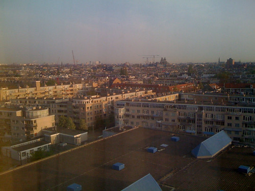
Location Business Summit with Walter Andrag and Bob Upham from Yahoo! Geo Technologies and Anil Patel and Chris Heilmann from YDN, the Yahoo! Developer Network. Another city, another hotel so this would be a good time for the obligatory through the window shot.

Through the Window #5 - Amsterdam

I'll be giving a talk on Hyperlocal or Hype (and Local)? later on this morning and will also be on a panel tomorrow morning, discussing how to try and monetize the growing geospatial web. This is the first Location Business Summit, so here's hoping it'll be geotastic.

Photo Credits: Foxgrrl and Kaptain Kobold on Flickr.

... and I'm here in the capital and largest city of the Netherlands for the first Location Business Summit with Walter Andrag and Bob Upham from Yahoo! Geo Technologies and Anil Patel and Chris Heilmann from YDN, the Yahoo! Developer Network. Another city, another hotel so this would be a good time for the obligatory through the window shot.

Through the Window #5 - Amsterdam

I'll be giving a talk on Hyperlocal or Hype (and Local)? later on this morning and will also be on a panel tomorrow morning, discussing how to try and monetize the growing geospatial web. This is the first Location Business Summit, so here's hoping it'll be geotastic.

Photo Credits: Foxgrrl and Kaptain Kobold on Flickr.