Posts tagged as "london"

The More The Web Changes, The More It Stays The Same (With A Map)

There's a saying in French which goes "plus ça change, plus c'est la même chose" which translates as the more things change, the more they stay the same. Maybe the same could be said to apply to today's World Wide Web ... "plus les changements web, plus le web reste le même", the more the Web changes, the more the Web stays the same, with blame firmly put at Google Translate if this doesn't translate properly.

Costa Rica And Nicaragua; A Border Dispute In The Age Of Web Maps

The popular press and media likes nothing better to poke fun at people who seem to ignore their own senses and instead rely on their GPS sat-nav systems, which frequently results in people ending up in the middle of fields, in the middle of rivers or even, in extreme cases, almost driving off of the edge of a cliff.

But the strangest example of this sort of behaviour was in the first reports of recent events on the border of Costa Rica and Nicaragua that seemed to implicate Google Maps as justification for Nicaraguan troops crossing the border into Costa Rica and raising the Nicaraguan flag on Costa Rican territory. The dispute seems to hark back to the 1850's where the contested border between the two countries followed the course of the San Juan River, the course of which has since moved somewhat, as rivers are wont to do. Costa Rica asserts their sovereignty on the disputed land based on the 1850's arbitrated border which follows the course of the river and Nicaragua asserts theirs based on the fact that the river has moved so some land must be theirs.

The BA Mobile Boarding Pass; So Right And Yet So Wrong

While boarding passes on your mobile handset have been around for a while in one form or another, I only came across them just over a year ago while flying on KLM from Amsterdam's Schipol airport. The system was quick, easy and worked, even though some of the staff at Schipol seemed a bit confused by me whipping out my mobile when they asked for my boarding pass, rather than the conventional printed boarding pass. At the time, I wondered when British Airways would follow suit. Now more than a year later, they have. Now to be fair, this system may have been in place for a while, but if it was it escaped me. Maybe I missed an email or some junk mail about this, but the first I heard of it when when I saw that the BA app on my iPhone had a new version and after some poking around to see what was new I saw the option for a mobile boarding pass.

Neogeography Is Dead (According To Wikipedia At Least)

Ahh ... paleogeography and neogeography; will the battle never end? The latter is a term used to refer to the combining of online mapping with data, incorporating classic cartography and GIS and exposed via Web 2.0 style mashups. The former is a term with dual meanings; one referring to the study of past and ancient geography and one being a pejorative to refer to the opposite and inverse of neogeography.

Good News

Both terms have their own entries on Wikipedia ... at least they used to. Towards the end of September 2010 the neogeography entry on Wikipedia was deleted with the justification ...

Berlin, Graffiti and Maps

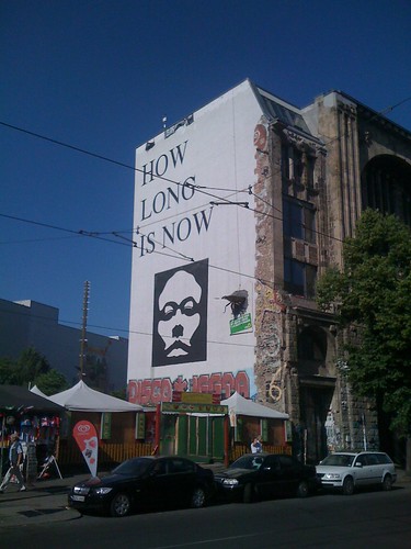
Like most cities these days, there's a lot of graffiti in Berlin. Some of it is just the mindless repetitive tagging where someone feels the need to display his or her tag over as much surface area as possible. But some of it aspires to art, especially the large displays found on the sides of buildings and high up on walls. A great example of this is the massive question (or maybe it's a statement) of How Long Is Now, found on the side of the Tacheles on Oranienburgerstraße, complete with a giant cockroach emerging from the wall.

How Long Is Now?

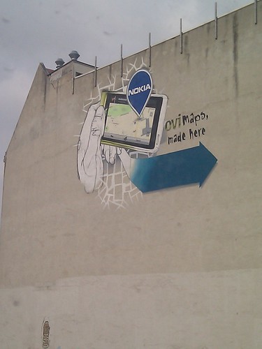
This grand painting style, part graffiti, part mural, part art seems to be iconic to a lot of the Mitte area of what used to be East Berlin. With this in mind, it's good to see that Nokia has decided to join in with this peculiarly Berlin trait with its own contribution, telling visitors walking along Invalidenstraße towards Nordbahnhof precisely what goes on in the Nokia Gate5 offices ... Ovi Maps, made here.

Ovi Maps. Made here. In Berlin

Creative Use Of Robots

I'm not talking about vaguely human looking machines here, the sort that crop up in Forbidden Planet and Lost In Space, waving their metal arms and saying things like "Danger Will Robinson". What I'm talking about is a small file called robots.txt.

T is for Tofu Robot

If you run your own web server you probably have one of these. It tells the web robots sent out by the search engines, such as Google, Yahoo! and Bing, what pages on your web site should and shouldn't be indexed and searchable. This doesn't mean that those pages can't be viewed, just that they shouldn't be able to be searched for.

Most of the time, a web site's robots.txt file contains stuff that is only of interest to the owner of the site and to people who specialise in getting the content of your web site to figure prominently in search engines. But sometimes, if you're willing to poke around a bit, they contain hidden gems, like a job advert for one of those aforementioned web search specialists, hidden in the UK Daily Mail's robots.txt file.

Finding Inspiration And Teaching Myself Location History At The BCS Geospatial SG

With GeoBabel firmly put to rest, I was looking for inspiration when Andrew Larcombe asked me back to the British Computer Society's Geospatial Specialist Group to speak. After a week of drawing a blank, with Andrew sending gentle messages of encouragement via Twitter Direct Message (OI - GALE. TITLE. NOW!!) inspiration finally arrived from a variety of sources. Firstly there was Mashable's History of Location Technology infographic. Then there the brief history of location slides I'd used in a few of my previous talks. There was the rather fine 3D visualisation of geolocation history that Chris Osborne used at W3G and at GeoCom 2010. And then there were two questions that kept cropping up when speaking to people at conferences ... "this location stuff's only recent isn't it?" and "I can't keep up with this geo stuff, it's all moving too fast, where's it going?".

So I started to research this. I knew that location had a long history but I was taken aback to find out just how long that history was. I'd tended to think of the human race using longitude and latitude to work out their location sometime in the 1700's, about the same time as the race to make a working, reliable marine chronometer. It came as a bit of a shock to find out that longitude and latitude were first proposed in 300 BC and were first used to locate a position on the surface of the Earth in 200 BC. Focussing on use of location, on location sharing and on LBS/LBMS and putting GIS to one side I came up with A (Mostly) Complete & (Mostly) Accurate History Of Location (Abridged).

Talking GeoBabel In Three Cities (And Then Retiring It)

You're invited to speak at a conference. Great. The organisers want a talk title and abstract and they want it pretty much immediately. Not so great; mind goes blank; what shall I talk about; help! With this in mind, my first thought is normally "can I adapt, cannibalise or repurpose one of my other talks?". This sometimes works. If there's a theme which you haven't fully worked through it can serve you well.

But a conference audience is an odd beast; a percentage of which will be "the usual suspects". They've seen you talk before, maybe a few times. The usual suspects also tend to hang out on the conference Twitter back channel. Woe betide if you recycle a talk or even some slides too many times; comments such as "I'm sure I've seen that slide before" start to crop up. Far better to come up with new and fresh material each time.

The Plains Of Awkward Public Family Interactions And The Bay Of Flames

Not content with pointing out the fun you can have with tracking your location, xkcd, the webcomic of romance, sarcasm, math and language has branched out into making maps. The updated map of online communities shows the volume of daily social activity across all of the online world, and not just the high profile ones that get the press coverage.

Click through for the full size versions and loose yourself in the plains of awkward public family interactions, the Bay Of Flames and other geographical wonders.

Crowd Sourcing The London Underground Tube Strike

From as early as 9.00 PM tonight, the London Underground network will be hit by a strike called by the RMT and TSSA unions. Again.

For Londoners this will probably come as no surprise, but this time around, the BBC are crowd-sourcing a map of station closures, services affected and the knock on impact to other forms of London public transport, using publicly submitted reports and media in addition to reporters on the street. It seems natural enough that this will be visualised on a map and in tonight's BBC London News, it was plainly evident that the BBC are using OpenStreetMap as the underlying map tiles for the visualisation.

You can see a snapshot of how the map looks, taken a few minutes ago; head over to the London Tube Strike Map for more updates as the strike starts to affect London.