New Vaguely Rude Places Map Base Map Tiles
The Vaguely Rude Places Map has had a minor behind-the-scenes update. Here, look at it in all its profane geospatial glory.
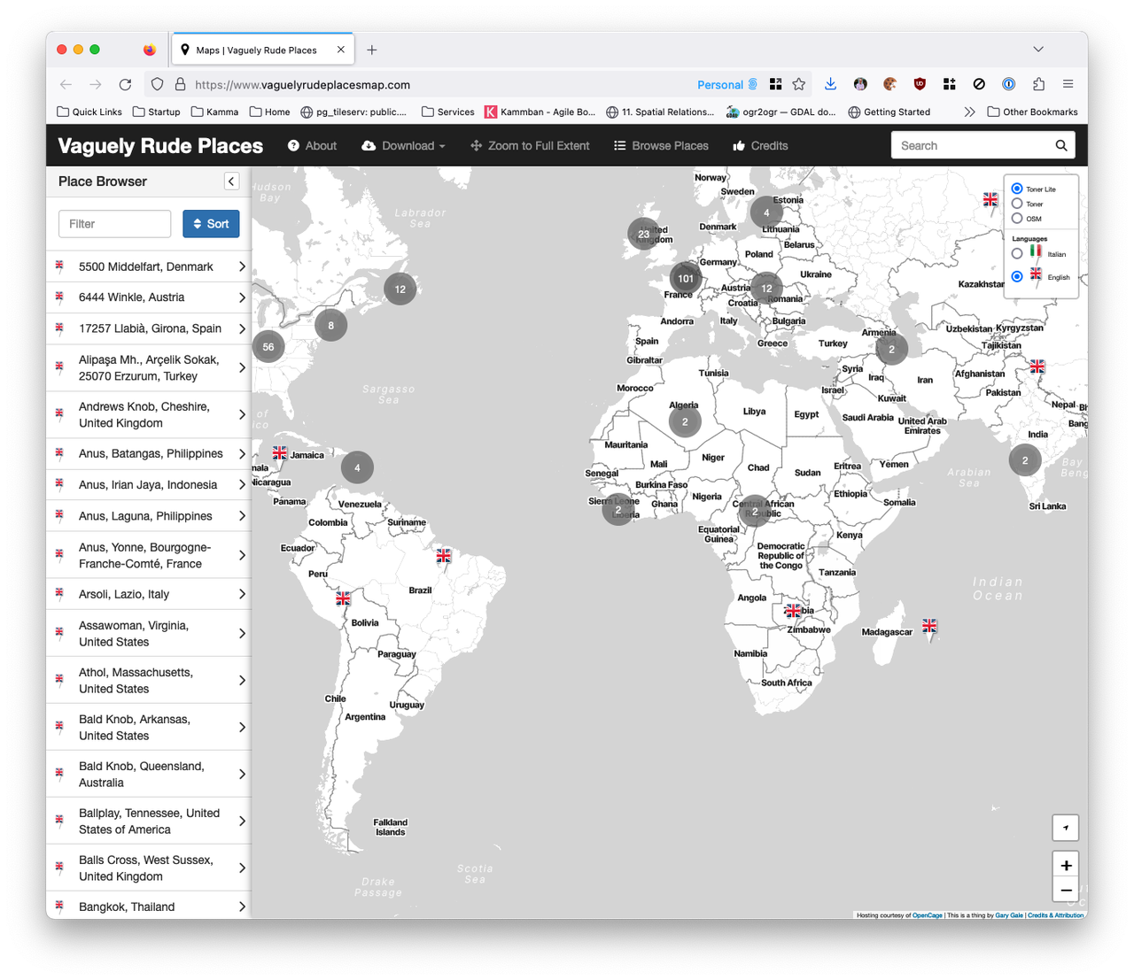
The Vaguely Rude Places Map has had a minor behind-the-scenes update. Here, look at it in all its profane geospatial glory.
This is part two of The Islands of the North Atlantic. In the first part of this occasional series of articles, I set the scene for what the United Kingdom is by tackling some common misconceptions of what the United Kingdom isn't.
But the United Kingdom of Great Britain and Northern Ireland that we know today only dates back to 1922, so I'm going to start with what the United Kingdom was and for that we need to go back to circa 927 CE and the Kingdom of England.
It was back in February of 2009 that I first wrote about the complex and confusing geographies of the British Isles, the United Kingdom and many other terms of reference for the archipelago of islands that sit off of the north-west coast of Europe and that I call home. Since then, with one notable exception, I have found myself having the same conversations on this topic at pretty much every place I've worked at.
So this is the first in a series of articles about the physical, political, administrative and other geographies of what's sometimes called the Islands of the North Atlantic, which should put this to rest ... until something else changes.
As the post COVID brain fog slowly clear and I get around to doing stuff I really meant to do but either couldn't summon up the energy to or just plain forgot about; it's time to tackle the growing list of issues and pull requests on the Vaguely Rude Places Map GitHub repo.
It's 2009 all over again. Or is it 2012? After a 2009 launch at SXSW, the much hyped location wars with Foursquare, Facebook Places and Google Latitude, acquisition by Facebook in 2011 and - to no one's surprise - shutting down in early 2012 ... Gowalla is back it seems.
Original co-founder Josh Williams is back at the helm and back at SXSW with the new Gowalla which looks awfully like the original Gowalla, only iOS only this time, with no web prescence to speak of and no Android app in the works or even planned.
But maybe things are different second time around. Rather than fighting it out with Foursquare and Swarm, this time once rival Dennis Crowley is on board as an investor. Only time will tell, but right now after re-registering my old account name (vicchi of course) after installing the app on my phone ... it's all a bit bare and waiting for people to add places. Of course, Foursquare started in just the same place but I have to scroll a long way into Central London to find some existing places to check-in to.
Even if you're not a cartographer, when you first see a map there's almost always a gut feel for whether you like a map or whether you don't. Critiquing a map is a deeply subjective thing. You may not know why you like a map but you can tell whether the map's cartography works or it doesn't work, for you at least.
The image at the top of this post is a great example of what I mean by this. It's a map of Berlin on the inside of an umbrella. Which is a great idea and this map is one I'm very fond of, both because of the time I spent in Berlin and because it was a present from one of my old HERE Maps team. But as a map, it's far from pleasing to me; I love what's being mapped, I just think it needs a better cartographer.
So much of what appears on today's digital maps is crowdsourced. Whether it's a totally crowdsourced map such as OpenStreetMaps' or a more focused effort such as HERE's Map Creator or Google's Map Maker, the so called wisdom of the crowd is an integral part of so many maps. But what would happen if you tried to crowdsource the critiquing of maps rather than the map itself?
Imagine for a moment you're in the city you live in; you know it like the back of your hand and yet you know there's shops, businesses or services nearby that you haven't yet come across. Or maybe you're in an unfamiliar city and you want to explore and stay away from the same old global brands that you see everywhere, in every city and on every street.
Now imagine putting this on a map.
"Ah hah!" you might say, reaching into your pocket and brandishing your smartphone. "I can do that easily" you say triumphantly as you fire up Google's or Apple's or HERE's mapping app.
But no, I'm talking about something a little more focused, a little less broad. "No worry" you say, firing up Foursquare, or Yelp or Facebook or TripAdvisor.
The geo industry has always been a fairly vaguely and nebulously defined industry and it takes a brave conference organiser to try and cover everything that's geo related in a single conference. But that's what GeoBusiness tries to do and it almost succeeds. This year's conference agenda and trade booth sideshow managed to cover the whole lifecycle of all things geo, from dodging drones, centimetre accurate GPS devices and LIDAR cars outside the Business Design Centre in London, through use of geo-data, with far too much BIM for my personal tastes, through mapping and cartography and ending up with crowd sourcing mapping data and using maps for emergency responses.
This year's high points were a jaw dropping talk on using airborne remote sensing to search for illicit nuclear explosions, surely a first for any conference I've been to, if only for the title alone and Chris Sheldrick from what3words recapping his talk on addressing the world. Less than high points were conference coffee that tasted like it had been brewed the month before and wifi that recalled the heady days of a 19.2K baud rate dial up modem. Thankfully the impending coffee emergency was prevented thanks to an espresso machine in the middle of the Leica exhibition stand and some rather fine coffee shops around the conference centre.
Last month, in response to the news that Uber had acquired LBS platform provider deCarta, Marc Prioleau penned an article asking is this the start of a mapping war?
A few days ago, Bloomberg announced news that Nokia is looking to sell off HERE, the maps business forged from the, sometimes unwilling, union of NAVTEQ and Nokia's Ovi Maps. Potential buyers for HERE include ... Uber.
This looks like either a skirmish before an all out map war offensive or this is the start of that mapping war.
When I first made the Vaguely Rude Places Map in February of 2013 I had no idea what was going to happen. Since then it's gone viral multiple times, been the subject of three conference talks, talked about on two radio stations, been covered in loads of newspapers and viewed millions of times. I still find it wryly amusing that the most successful map I've made to date has had nothing to do with my day job.