Posts about flickr

Map Push Pins vs. Dots? Google Map Engine vs. Dotspotting?

Google launched their Maps Engine Lite beta; a way of quickly and easily visualising small scale geographic data sets on (unsurprisingly) a Google map. The service allows you to upload a CSV file containing geographic information and style the resulting map with the data added to it. I thought I'd give it a try.

I turned to my tried and trusted data set for things like this; a data set I derived from a Flickr set of geotagged photos I'd taken of the London Elephant Parade in 2010. It's a known data source and I know what the results of this data set will give me; it lets me do a reasonably meaningful visual comparison of how a particular product or service interprets and displays the data.
Yesterday, Google launched their Maps Engine Lite beta; a way of quickly and easily visualising small scale geographic data sets on (unsurprisingly) a Google map. The service allows you to upload a CSV file containing geographic information and style the resulting map with the data added to it. I thought I'd give it a try.

I turned to my tried and trusted data set for things like this; a data set I derived from a Flickr set of geotagged photos I'd taken of the London Elephant Parade in 2010. It's a known data source and I know what the results of this data set will give me; it lets me do a reasonably meaningful visual comparison of how a particular product or service interprets and displays the data.

Google Maps Engine

Reading up on Map Engine Lite, I noted that I could only upload a maximum of 100 data points into a layer on the map, which wasn't a problem as my data set is localised to London and contains only 10 pieces of information, one for each photo I'd taken. Once I'd uploaded the data I could style the colours of the push pins and the background style of the map. It looks pretty good, even if you are limited to 100 points per layer and it's for strictly personal and non commercial use only.

But I was sure I'd seen this sort of thing before and I had, in the form of Stamen's Dotspotting. I already had an account with Dotspotting and, even though I'd forgotten about it, I'd previously made a map from my London Elephants data set.

DotSpotting

The parallels are many. Both Map Engine and Dotspotting allow you to upload data in CSV format. Both services try to work out coordinates from the data, if there's no lat/long coordinates already. Both services allow you to style the resultant map.

There are differences. Dotspotting allows you to download your data; it doesn't appear that Google does. Map Engine allows you to style the map markers; it doesn't seem that Dotspotting allows this. Dotspotting supports Excel spreadsheets, CSV files, Flickr and Google My Maps feeds; Map Engine only supports CSV files.

There's also one other key difference; Map Engine was launched yesterday, whilst Dotspotting was launched 2 years ago.

But there's an old saying that imitation is the sincerest form of flattery.

RIP FireEagle. You Shall Share Location No More

wrote some words that at the time seemed full of hope for the future of the Geotechnologies group I'd left.

I’ll continue to use my core set of Yahoo! products, tools and APIs … YQL, Placemaker, GeoPlanet, WOEIDs, YUI, Flickr and Delicious. Not because I used to work for Yahoo! but because they’re superb products.

Time and changes of corporate heart have not been kind here. Maybe it's time to take a look at the state of the geo union.

Back in 2010, when I left Yahoo! to go and join Nokia, I wrote some words that at the time seemed full of hope for the future of the Geotechnologies group I'd left.

I’ll continue to use my core set of Yahoo! products, tools and APIs … YQL, Placemaker, GeoPlanet, WOEIDs, YUI, Flickr and Delicious. Not because I used to work for Yahoo! but because they’re superb products.

Time and changes of corporate heart have not been kind here. Maybe it's time to take a look at the state of the geo union.

YQL. The Yahoo! Query Language. Still here although I haven't used it in anger for several years as the service was frequently down.

Yahoo! Maps and the Yahoo! Maps API. RIP. Yahoo! Maps is now run by the back-end services of Nokia, my current employer and the Yahoo! Maps API finally got switched off in November 2012.

Placemaker and PlaceFinder. Still here. Sort of. Placemaker is now Placespotter and while PlaceFinder keeps its name they're both part of Yahoo! BOSS Geo, which means if you want to use them it's time to dig into your wallet for your credit card as they're no longer free to use.

GeoPlanet. Still here. Still free. You have to ask the question for how long though.

WOEIDs. Still here and although you can still use WOEIDs through the GeoPlanet and Flickr APIs, the GeoPlanet Data download remains offline, although see also the fact that there's no delete button for the Internet. WOEIDs are probably not going to go anywhere soon as Yahoo's geotargeting platform depends on them. For now.

YUI. Still here and open sourced on GitHub.

Flickr. Still here, used on a regular basis by me and even flourishing with a renewed iPhone app and a horde of refugees from Instagram after that service's on, off, on again change of licensing terms in December 2012.

Delicious. Still here and still used on a relatively regular basis by me but no longer owned or operated by Yahoo! who sold it to AVOS in 2011.

Did I mention that the old Yahoo! Geo Technologies blog, after years of being down, now redirects to the Yahoo! corporate blog? No? Well it does.

And now it seems that another of Yahoo's geo products has finally done to the deadpool as FireEagle finally stops sharing people's locations and Tom Coates, who I remember discussing what would become FireEagle over coffee back when we both worked at Yahoo, was in a sanguine mood on Twitter.

Tom Coates - FireEagle

The fate of FireEagle has long been been in the balance since it was mentioned as one of the products due to be sunsetted or merged with another product in 2010. The merging never happened and now FireEagle is no more.

Which is a great shame as FireEagle was way ahead of its time and in today's age of location based services and social media sharing, the need for a way to share your location that makes sense for both the privacy of individuals and for businesses is needed more than ever.

If anyone's looking to resurrect the notion of FireEagle, hopefully you'll be the first to let me know.

The Opposite Of Geolocation Is ... Relocation?

elsewhere on this blog but this post merits another. I used to work for Yahoo! as part of the Geo Technologies group. I now work for Nokia as part of their Location group. The opinions and ideas expressed in this post are absolutely just my own, and should not be confused with, or taken for, those of my current or past employers. It's just me here.

You may not have realised it but Friday May 27th. was a sad day for the Geo industry in London. Even without the benefit of knowing what was going on from ex-colleagues inside the company, the signs were there if you knew where to look for them and how to read them.

Before the Internet, companies, teams and projects could fade quietly into anonymity and into oblivion. But on the Internet, everything is in public and it's much harder to hide the tell tale signs. API updates and bug fixes cease. A web site or blog stops being updated or goes down altogether. A Twitter feed stops being an active living thing and becomes merely a historical record. Ex-colleagues start following you on Twitter or you start getting connection requests on LinkedIn whilst other colleagues start polishing and updating their LinkedIn profiles.

And May 27th. 2011? That was the day that the last of the remaining members of my old team at Yahoo! Geo Technologies left the Yahoo! office in London and that was the day that Yahoo! ceased to have a Geo presence in the UK.

First a disclaimer; there's one elsewhere on this blog but this post merits another. I used to work for Yahoo! as part of the Geo Technologies group. I now work for Nokia as part of their Location group. The opinions and ideas expressed in this post are absolutely just my own, and should not be confused with, or taken for, those of my current or past employers. It's just me here.

You may not have realised it but Friday May 27th. was a sad day for the Geo industry in London. Even without the benefit of knowing what was going on from ex-colleagues inside the company, the signs were there if you knew where to look for them and how to read them.

Before the Internet, companies, teams and projects could fade quietly into anonymity and into oblivion. But on the Internet, everything is in public and it's much harder to hide the tell tale signs. API updates and bug fixes cease. A web site or blog stops being updated or goes down altogether. A Twitter feed stops being an active living thing and becomes merely a historical record. Ex-colleagues start following you on Twitter or you start getting connection requests on LinkedIn whilst other colleagues start polishing and updating their LinkedIn profiles.

And May 27th. 2011? That was the day that the last of the remaining members of my old team at Yahoo! Geo Technologies left the Yahoo! office in London and that was the day that Yahoo! ceased to have a Geo presence in the UK.

Sad Yahoo! Smiley

I joined Yahoo! in 2006 as Engineering Manager for Geo Location Targeting, also known as GLT (and not standing for Gay, Lesbian and Transgender, a mistake once made by someone at a conference with hilarious consequences), a group formed from the acquisition of WhereOnEarth.com a year earlier in 2005. As the name suggests, GLT was formed to use WhereOnEarth's technology to build Panama, Yahoo's geotargeting ad platform, a task which the technology was well suited to and a task at which the team succeeded.

But post Panama, we faced the challenge that most acquisitions face ... "we've done what we were acquired for ... now what"? In 2008 we started to answer the "now what?" question. With Tom Coates and the Yahoo! Brickhouse team, we provided the back-end geo platform for Fire Eagle. With Aaron Cope and Dan Catt, we provided the back-end geo platform for geotagging photos on Flickr. And with Martin Barnes, Tyler Bell and Mark Law we launched the GeoPlanet geodata gazetter API and the Placemaker geoparsing API. These were heady days for geo; GPS was reaching critical mass in consumer devices and web service mashups were ready to take advantage of powerful geo APIs and with Chris Heilmann evangelising furiously as part of YDN, the Yahoo! Developer Network, we were well placed to take the lead in the explosion of interest in all things geo that was starting then and continues to this day.

Yahoo!

Yet the company didn't seem to know what to do with their Geo Technologies group. We were reorganised more times that I can remember, starting again with another Vice President and another group. The promising lead in this area started to loose ground and the long promised investment never seemed to materialise. In May 2010, Nokia made me an offer to be part of the their location group that I couldn't refuse and I jumped ship. TechCrunch seemed to like this; twice to be exact. Over the next 12 months the group in London continued to shrink and continued to lack investment. The signs were all there for anyone to read ... the YahooGeo Twitter feed was last updated in January 2011 with a total of 5 Tweets since I handed over the reins on May 28th. 2010. The blog at www.ygeoblog.com has been down for almost a year as well.

And on Friday May 27th. 2011, the last of the London team left the office in London's Covent Garden for the final time as the Geo Technologies group transitioned and relocated to the Yahoo! corporate headquarters in Sunnyvale, California and to Bangalore; a sad day for the team in London and a sad day for the Geo industry overall. Hopefully the future will yield more developments of the YDN Geo APIs and the WOEID geoidentifier and while Geo Technologies in the company continues to live and to power the successor to the Panama geotargeting platform, the London presence where the technology grew and was developed is over.

The Delicious Debacle And My Dependence On The Cloud

leaving Yahoo! to join Nokia I wrote ...

So whilst I’m going to Nokia, I’ll continue to use my core set of Yahoo! products, tools and APIs … YQL, Placemaker, GeoPlanet, WOEIDs, YUI, Flickr and Delicious. Not because I used to work for Yahoo! but because they’re superb products.

That's still true but the recent news of the closure, or shutting down, or selling off of Delicious has been one of those significant events that makes you sit up and take notice. In this case, it's made me take notice of just how much I rely on the vague and nebulous technology we call the Cloud.

About 6 months ago, when I announced that after 4 years I was leaving Yahoo! to join Nokia I wrote ...

So whilst I’m going to Nokia, I’ll continue to use my core set of Yahoo! products, tools and APIs … YQL, Placemaker, GeoPlanet, WOEIDs, YUI, Flickr and Delicious. Not because I used to work for Yahoo! but because they’re superb products.

That's still true but the recent news of the closure, or shutting down, or selling off of Delicious has been one of those significant events that makes you sit up and take notice. In this case, it's made me take notice of just how much I rely on the vague and nebulous technology we call the Cloud.

Delicious So before going any further, it's probably worth stating my own, totally subjective, view of what the Cloud is. It turns out that it's actually a fairly simplistic definition. The Cloud is any form of remotely access storage where we put content, with the addition that there's frequently a service and/or an API built on top of that storage. More importantly, it's all of this content we produce and store in the Cloud that the fate of Delicious has shone a spotlight on. A quick, off the top of my head, list of Cloud based content looks something like this ...

The future of Delicious has made me think long and hard and ask three questions. How much of this content is easily exported or stored elsewhere? How irreplaceable is this content? How at risk is the service hosting the content?

A quick look at the list above gives me ample cause for concern. There's a lot of content I rely upon that is hosted on Cloud services over which I have little or no control and which often offer no means of exporting that data easily, if at all. But it gets worse ...

Flickr There's a massive amount of reliance and interdependence on each of these services. My blog relies on other Cloud services, for example almost every one of my blog posts is illustrated either with an embedded slide deck from Slideshare, with an embedded photo from Flickr or both. This post is a classic example of that. My other web site, at www.garygale.com, is dynamic and is almost entirely reliant on my Delicious bookmarks for providing links to my content hosted in other Cloud services.

The delicious irony here (pun fully intended) is that while the internet and the web are massively decentralised, they've been used to create a whole set of centralised and silo'd Cloud services, a large number of which my web presences rely upon. In the case of Delicious, I'll stick with the service for now, until its future becomes less murky but as with my short URLs, hosting my own set of bookmarks will probably be on the agenda for early in 2011, along with the resulting disruption and work this will cause in integrating this new service into my web sites. But at least I'll be owning and controlling my own Cloud services.

Photo Credits: Shaneblog on Flickr.

When Maps and Data Collide They Produce ... Art?

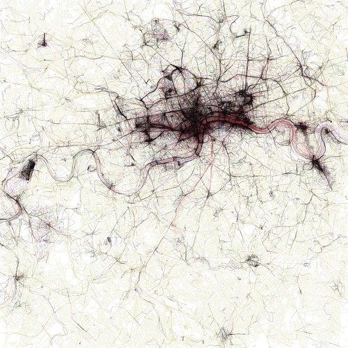
The Geotaggers' World Atlas #2: London

It's instead an image from the Geotagger's World Atlas but it's still unintentionally beautiful.

Last month I wrote that a map says as much about the fears, hopes, dreams and prejudices of its target audience as it does about the relationship of places on the surface of the Earth. With the benefit of hindsight I think I was only half way right.

Sometimes a map becomes more than just a spatial representation and becomes something else.

Sometimes a data visualisation becomes more than just the underlying data and almost takes on a life of its own.

When these two things meet or collide the results can be spectacularly compelling and produce, unintentionally ... art? Look at the image below ... filigree lace work? Crochet for the deranged of mind? Silk for the sociopath? Macrame for the mad? Sadly none of the above.

The Geotaggers' World Atlas #2: London

It's instead an image from the Geotagger's World Atlas but it's still unintentionally beautiful.

The maps are ordered by the number of pictures taken in the central cluster of each one. This is a little unfair to aggressively polycentric cities like Tokyo and Los Angeles, which probably get lower placement than they really deserve because there are gaps where no one took any pictures. The central cluster of each map is not necessarily in the center of each image, because the image bounds are chosen to include as many geotagged locations as possible near the central cluster. All the maps are to the same scale, chosen to be just large enough for the central New York cluster to fit. The photo locations come from the public Flickr and Picasa search APIs.

I could look and stare at the all the images in Eric's Flickr set for hours. Correction, I have stared at the images for hours. Photo Credits: Eric Fischer on Flickr.

Phi, Lambda and (Slightly Embarassing) Temporality

Astride The World

Which is why I think identifier systems, such as Yahoo's WOEID, add so much value. A WOEID adds a linked web of rich metadata, describing not only a point with a long/lat centroid, but also reinforces the concept of a place, with neighbouring and hierarchical relationships.

Coordinates describe the where of a place, identifiers such as WOEIDs describe the how of a place but both conveniently (in a slight embarrassed, foot shuffling short of way) overlook the when of a place.

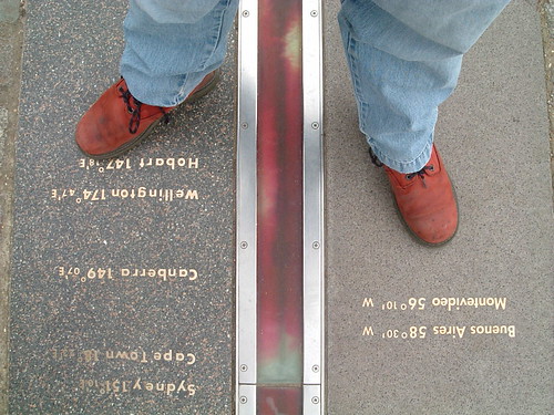
Longitude and latitude have been formally used as a geographic coordinate system offset from the Greenwich Meridian since the International Meridian Conference of 1884 in Washington D.C.

As a spatial coordinate system, longitude (abbreviated as φ, or phi) and latitude ( λ, or lambda) work very well in defining a point on the surface of the Earth. But to gain further meaning from a long/lat pair you either need some clever algorithmics or you need to plot the long/lat point on a map which even then will yield information only as good as that which is rendered on the map itself.

Astride The World

Which is why I think identifier systems, such as Yahoo's WOEID, add so much value. A WOEID adds a linked web of rich metadata, describing not only a point with a long/lat centroid, but also reinforces the concept of a place, with neighbouring and hierarchical relationships.

Coordinates describe the where of a place, identifiers such as WOEIDs describe the how of a place but both conveniently (in a slight embarrassed, foot shuffling short of way) overlook the when of a place.

Former Flickr geo-hacker and current Stamen Design geo-hacker, Aaron Cope, posted a way around the temporality problem on his blog this evening, describing spacetimeid, a web app which encodes and decodes a 64-bit identifier combining x, y and z coordinates.

So far, so timely; a spacetimeid allows us to describe not only a point but also a time. The logical next step to this is to allow the encoding of a WOEID, that includes a long/lat centroid, with a time range. Two immediate use cases spring to mind.

Firstly, this allows us to represent places which have a small temporal range, such as festival or concert venues; this is frequently referred to as The Burning Man Problem, after the annual festival of the same name. During the duration of the festival Burning Man exists as a concrete place, outside of the festival timescales the site of the festival is empty land.

Burning Man 2007

Secondly, this allows us to represent changes in places over a large temporal range, which can be used to rectify historical maps and show the change in a place over a number of years.

I pinged Aaron a mail on this, saying "Encode temporal information in range format plus WOEIDs ? ... Thinking a WOEID for Burning Man or similar here". He replied a few minutes later with "Yes, that would be easy enough to do if the (x) is the WOEID and the (y) time. I can add that later". Followed, in the time it's taken me to write this post, with "Ask and all that ... https://spacetimeid.appspot.com/woe/encode/44418/1268854022".

Now all we need to do is get this used in the real world and the slightly embarassing problem of temporality will have been solved once and for all. Easy isn't it?

Photo Credits: Foxgrrl and Kaptain Kobold on Flickr.

Creative Commons in Action

Flickr photo stream. While some of them are taken with a proper camera  (though some would say that my Lumix FX12 isn't a proper camera), most of them are taken with my iPhone, which doesn't take great pictures but takes pictures which are good enough and with the added bonus that I have it on me almost all of the time.

My photos all used to be publicly accessible and with an all rights reserved copyright on them but then I lost my Flickr innocence, which was a bad thing at the time and switched all of my photos to friends and family visibility. About a week later, when I'd calmed down a bit, I went through all of my photo sets; photos of my family and of home stayed out of the public eye and stayed all rights reserved. But everything else, I opened up and changed the license to some rights reserved using the Creative Commons Attribution Share-Alike license.

I take a lot of photos, most of which end up on my Flickr photo stream. While some of them are taken with a proper camera  (though some would say that my Lumix FX12 isn't a proper camera), most of them are taken with my iPhone, which doesn't take great pictures but takes pictures which are good enough and with the added bonus that I have it on me almost all of the time.

My photos all used to be publicly accessible and with an all rights reserved copyright on them but then I lost my Flickr innocence, which was a bad thing at the time and switched all of my photos to friends and family visibility. About a week later, when I'd calmed down a bit, I went through all of my photo sets; photos of my family and of home stayed out of the public eye and stayed all rights reserved. But everything else, I opened up and changed the license to some rights reserved using the Creative Commons Attribution Share-Alike license.

Royal Festival Hall Lights

The reasoning behind this was that pretty much every slide on every deck I put together has a background from Flickr which is licensed under the Creative Commons model. Without this license and without people releasing their photos using it, my slide decks would be altogether poorer and a whole lot blander.

Opening up some of my photos under Creative Commons works both ways. In February I received a mail from someone at Schmap telling me that two of my, Creative Commons licensed, photos had been shortlisted for including in the next edition of their London guide. Instantly suspicious of this I asked the Twitter-verse for commentary; Vikki Chowney, Lorna Brown and Tim Moore were good enough to respond and tell me that this wasn't a scam, as my cynical mind had first surmised.

Soba Soba Soba

It's not much in the grand scheme of things but the people at Schmap either liked the photos I'd taken of the Royal Festival Hall and in Chinatown's Tokyo Diner (less likely) or didn't have any other suitable candidates and so plumped for mine (much more likely). Either way, this was a great example of Creative Commons in action and it allows me to continue to mine Flickr's ever growing pool of photos for my slide decks with a clear conscience.

Deliciousness: ringing phones, suicide linux, Flickr plugins, editing, zoomable maps and upsidedownness

social bookmarking deliciousness, from down the back of the internet.
  • Got a colleague who keeps wandering away from their desk and leaving their mobile phone behind, which then keeps on ringing? Maybe they need one of these signs left on their desk. Maybe.
  • Fancy a challenge? How many times a day do you type the incorrect command at the shell? Once, twice, three times a day? More? Maybe you should give Suicide Linux a try; it helpfully turns any mistyped command into rm -rf / thus helpfully erasing your root file system. Concentrate now.
  • The WordPress Flickr Manager is a wonderful plugin which integrates your Flickr photostream into blog posts. Alas it doesn't work with WordPress 2.9. Until now.
  • Posting the same article to multiple blogs severely impacts your search engine ranking results. How did I not know this? It's stopped at least one person from using the Posterous autopost function.
  • Sometimes, just sometimes, sub-editors trim just a little bit too much from an article prior to publishing.
  • We're used to online slippy maps being able to zoom in and out; but zooming in and out of paper maps? That's something else indeed.
  • What's happens in Vegas stays in Vegas; but sometimes it stays on FourSquare as well.
  • Photo of the year so far; the Space Shuttle Endeavour, caught in silhouette from the International Space Station. That phrase alone sounds like it's been lifted wholesale from an Arthur. C. Clarke novel.
  • ˙uʍop ǝpısdn ǝdʎʇ oʇ pǝǝu noʎ 'sǝɯıʇǝɯos ʇsnɾ 'sǝɯıʇǝɯos

Written and posted from home (51.427051, -0.333344)

Today's social bookmarking deliciousness, from down the back of the internet.

  • Got a colleague who keeps wandering away from their desk and leaving their mobile phone behind, which then keeps on ringing? Maybe they need one of these signs left on their desk. Maybe.
  • Fancy a challenge? How many times a day do you type the incorrect command at the shell? Once, twice, three times a day? More? Maybe you should give Suicide Linux a try; it helpfully turns any mistyped command into rm -rf / thus helpfully erasing your root file system. Concentrate now.
  • The WordPress Flickr Manager is a wonderful plugin which integrates your Flickr photostream into blog posts. Alas it doesn't work with WordPress 2.9. Until now.
  • Posting the same article to multiple blogs severely impacts your search engine ranking results. How did I not know this? It's stopped at least one person from using the Posterous autopost function.
  • Sometimes, just sometimes, sub-editors trim just a little bit too much from an article prior to publishing.
  • We're used to online slippy maps being able to zoom in and out; but zooming in and out of paper maps? That's something else indeed.
  • What's happens in Vegas stays in Vegas; but sometimes it stays on FourSquare as well.
  • Photo of the year so far; the Space Shuttle Endeavour, caught in silhouette from the International Space Station. That phrase alone sounds like it's been lifted wholesale from an Arthur. C. Clarke novel.
  • ˙uʍop ǝpısdn ǝdʎʇ oʇ pǝǝu noʎ 'sǝɯıʇǝɯos ʇsnɾ 'sǝɯıʇǝɯos

Written and posted from home (51.427051, -0.333344)

Loosing My Flickr Innocence

Flickr account and there's a lot of photos, almost 3.5 thousand at the last count. Most of these almost 3.5 thousand photos are of my family, my wife, my children and last year I changed my default upload model from "anyone can see this" to "only friends and family can see this" and I went back and changed permissions on those photos I'd uploaded. On all of them. Or so I thought.

I'm writing this in my hotel room in New York, where I've been taking part in Yahoo's Open Hack NYC event and I've been taking a lot of photos which I've been posting to Flickr. Some people seem to like these photos and favourite them; each time this happens I get a nice friendly mail from Flickr telling me this. So this morning I went and looked at all the photos of mine that had been added as a favourite and I didn't like what I found. There was a photo taken last year while on holiday; a photo of one of my children, a photo which I thought was "friends and family only".

We all produce lots of online content these days; photos, videos, blogs, microblogs, status updates, Tweets, that sort of thing. Most of the pictures I produce go up on my Flickr account and there's a lot of photos, almost 3.5 thousand at the last count. Most of these almost 3.5 thousand photos are of my family, my wife, my children and last year I changed my default upload model from "anyone can see this" to "only friends and family can see this" and I went back and changed permissions on those photos I'd uploaded. On all of them. Or so I thought.

I'm writing this in my hotel room in New York, where I've been taking part in Yahoo's Open Hack NYC event and I've been taking a lot of photos which I've been posting to Flickr. Some people seem to like these photos and favourite them; each time this happens I get a nice friendly mail from Flickr telling me this. So this morning I went and looked at all the photos of mine that had been added as a favourite and I didn't like what I found. There was a photo taken last year while on holiday; a photo of one of my children, a photo which I thought was "friends and family only".

I didn't recognise the Flickr account name of the person who liked this shot so much, so I took a look at their profile. One of the things in your profile are the groups you belong to ... I belong to two, both tech related. This person belonged to a lot and I had to scroll down a page to see them all. They were all of an adult nature, seeming to be centred around sharing snaps of other peoples spouses; you know the sort of thing.This was creepy. Very creepy.So I blocked the user and went through all of my photos to ensure that nothing else was inadvertantly exposed to public view that I didn't want and luckily nothing was. I checked the Flickr Community Guidelines and one of them seemed to fit the situation really well. So if you previously used to watch my Flickr account for photos, you'll be a little disappointed as they've vanished from public view. I'm sorry about that. If I know you and you'd like to see them, just add me as a Flickr contact. If you don't have a Flickr account and don't want one, then please drop me a mail and I'll send you a guest pass link to use. I probably shouldn't be shocked or surprised by this but I am and today it feels just a bit like my Flickr innocence was lost. I'll get over it and be a little bit older, a little bit wiser and just a little bit more careful in the future.  Posted via email from Gary's Posterous

NYC Beware : The Trinity of Geo Is Coming

I've never been publicly seen in the same room as Aaron Cope and Tom Coates before.

Ever noticed how you never see some people in the same room together? Various conspiracy theories abound on this theme; that they're really the same person or that they're mortal enemies. All complete rubbish of course but maybe there's some truth in this after all ... I've never been publicly seen in the same room as Aaron Cope and Tom Coates before.

Benedictus de Spinoza said that nature abhors a vaccum and Heisenberg calculated the critical mass needed for a nuclear reaction so maybe there's a halfway stage between these two extremes, a geocritical mass if you will.I really should explain ...When people ask me what it is that I do for Yahoo!, I explain that I help use geography to describe people, places and things.A rather jovial looking Tom.People are knowing where users are and the things that are important to them. Fire Eagle, Yahoo's location brokerage platform allows users to share their location on the web, to update anywhere and to choose what you share and don't share. Tom is the man behind the creation of Fire Eagle and was responsible for leading the (now defunct) Yahoo! Brickhouse team to produce the best location service there is on the 'net.Wherecamp '09 in Palo Alto; that's "geotechnologist and ATM user" Tyler Bell on the left, myself in the middle and  Aaron on the right.Places are knowing geographic locations and the names of places. That's the remit of Geo Technologies, my group at Yahoo! and you can see this in the public web service platforms we produce such as GeoPlanet and Placemaker, all linked using the geoidentifier we call WOEIDs.Things are knowing the geographic context of content. Flickr allows you to geotag your photos, using my group's technology and in February of this year broke the amazing 100 million geotagged photo mark. If you've seen him speak at Where 2.0, Wherecamp or previous Hack Days, you'll know that Aaron knows the power of geo and has used it to produce something rather unique and special at Flickr. Geocritical mass (which doesn't currently show us in any search engine, so you saw it first here) may well be reached next week in the Millennium Broadway hotel in Times Square, New York when all three of us will be in the same place, at the same time for Open Hack NYC, 48 hours of hacking goodness with a generous helping of geo. Who knows what will happen, all I can say is that a trinity of geopeople are coming to NYC and that it'll be geotastic. Posted via email from Gary's Posterous

Plenaries, Privacy and Place

You Don't Always Get What You Pay For, But Sometimes You Get It For Free

Here in the UK we're used to bad or non-existent customer service, so much so that it's virtually ingrained into our genes. We're well aware of the oft used expression that you get what you pay for except that you actually don't; you continue to pay and act pleasantly surprised when you actually get what you've paid for, murmuring "well that's a turn up for the books". We look longingly across the Atlantic to the US and talk admiringly of the "American service culture" whilst conveniently overlooking the fact that our US counterparts get paid rock bottom wages and have to work damn hard to garner enough tips to make a living.

But there are exceptions and the global geographic reach of the Internet means that those here in the UK we get to benefit from these exceptions. Consider the following case of Internet startup (and yes, it's a US Internet startup but let's just conveniently overlook that for a moment) posterous.com. Now I know I'm writing about Posterous a lot at the moment but indulge me for a moment.Whilst playing with Posterous' free, yes free, service I noticed a slight ... deficiency which I documented here. Posterous claims to handle links to images in a sane manner; their FAQ says"We’ll do smarter things for photos, MP3’s, documents and video (both links AND files)”.So I tried a sample post with links to TwitPicYFrogFlickr and, pushing it a bit, Facebook. YFrog and Flickr worked flawlessly, Facebook didn't but that wasn't unexpected, but TwitPic didn't and that was unexpected. So I noted this in a Twitter post directed at the Posterous Twitter account: And there I left it, either expecting a non committal response, or none at all. Twenty four minutes later, two four, twenty four, I got a reply.

What? Just like that? Surely not, they obviously meant they'd added it to the list of stuff they really need to fix. But apparently not. And I tested it and it worked. Conditioned as I am to the UK norm, this was pretty unheard of, hence the need to write this experience up. So on the Internet, at least, you don't always get what you pay for, but sometimes you get it for free. Posted via email from Gary's Posterous