New Vaguely Rude Places Map Base Map Tiles
The Vaguely Rude Places Map has had a minor behind-the-scenes update. Here, look at it in all its profane geospatial glory.
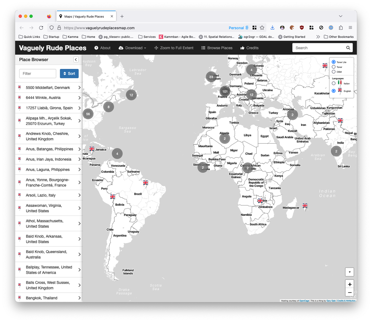
The Vaguely Rude Places Map has had a minor behind-the-scenes update. Here, look at it in all its profane geospatial glory.
This is part two of The Islands of the North Atlantic. In the first part of this occasional series of articles, I set the scene for what the United Kingdom is by tackling some common misconceptions of what the United Kingdom isn't.
But the United Kingdom of Great Britain and Northern Ireland that we know today only dates back to 1922, so I'm going to start with what the United Kingdom was and for that we need to go back to circa 927 CE and the Kingdom of England.
It was back in February of 2009 that I first wrote about the complex and confusing geographies of the British Isles, the United Kingdom and many other terms of reference for the archipelago of islands that sit off of the north-west coast of Europe and that I call home. Since then, with one notable exception, I have found myself having the same conversations on this topic at pretty much every place I've worked at.
So this is the first in a series of articles about the physical, political, administrative and other geographies of what's sometimes called the Islands of the North Atlantic, which should put this to rest ... until something else changes.
Even if you're not a cartographer, when you first see a map there's almost always a gut feel for whether you like a map or whether you don't. Critiquing a map is a deeply subjective thing. You may not know why you like a map but you can tell whether the map's cartography works or it doesn't work, for you at least.
The image at the top of this post is a great example of what I mean by this. It's a map of Berlin on the inside of an umbrella. Which is a great idea and this map is one I'm very fond of, both because of the time I spent in Berlin and because it was a present from one of my old HERE Maps team. But as a map, it's far from pleasing to me; I love what's being mapped, I just think it needs a better cartographer.
So much of what appears on today's digital maps is crowdsourced. Whether it's a totally crowdsourced map such as OpenStreetMaps' or a more focused effort such as HERE's Map Creator or Google's Map Maker, the so called wisdom of the crowd is an integral part of so many maps. But what would happen if you tried to crowdsource the critiquing of maps rather than the map itself?
Imagine for a moment you're in the city you live in; you know it like the back of your hand and yet you know there's shops, businesses or services nearby that you haven't yet come across. Or maybe you're in an unfamiliar city and you want to explore and stay away from the same old global brands that you see everywhere, in every city and on every street.
Now imagine putting this on a map.
"Ah hah!" you might say, reaching into your pocket and brandishing your smartphone. "I can do that easily" you say triumphantly as you fire up Google's or Apple's or HERE's mapping app.
But no, I'm talking about something a little more focused, a little less broad. "No worry" you say, firing up Foursquare, or Yelp or Facebook or TripAdvisor.
When I first made the Vaguely Rude Places Map in February of 2013 I had no idea what was going to happen. Since then it's gone viral multiple times, been the subject of three conference talks, talked about on two radio stations, been covered in loads of newspapers and viewed millions of times. I still find it wryly amusing that the most successful map I've made to date has had nothing to do with my day job.
So farewell Sir Terry Pratchett. Since I first read The Colour Of Magic in 1983 you made me smile, you made me laugh out loud and above all, you always made me think.
In 2004's Going Postal, Terry wrote about the clacks, a series of semaphore towers that were the Discworld equivalent of the old telegraph system. There was a tradition that when a clacks worker dies in the line of duty, their name would be sent home by being transmitted up and down the line in the signalling layer of the clacks message protocol.
Somewhere around 1510 what is now known as the Lenox Globe was made. Apart from being either the second or third oldest globe in existence, the Lenox Globe is infamous for the first appearance of the Latin Phrase HIC SVNT DRACONES, which is today loosely translated as here be dragons. This is probably not a reference to the precise location of dragons, but is thought to be a reference to the Kingdom of Dragoian in Sumatra which was noted by Marco Polo during his travels. Nowadays the phrase is commonly taken to mean "here is stuff we don't know about or which hasn't happened yet".
All of which reminds me of a conversation I had with a member of the finance team in a previous job; the company name is redacted to prevent embarrassment. The conversation went something like this ... "So, when will this map of yours be finished?" "It won't; the world is always changing". "Well I need a date for reporting against, so can I say the map will be finished at the end of the financial year?"
When I was a lot younger than I am now I learned the address of where I was growing up. More about that in a moment. First I want to mention what I didn't learn.
I didn't learn that I was at TQ 23210 65789. Nor did I learn that I lived at 51.377792, -0.23107184. In just the same way that you probably pointed your browser at www.vicchi.org rather than 91.146.108.26, because letters and words are easier to remember than numbers, I didn't learn the OS grid reference or the latitude and longitude of my home.
Instead I learned the address. I learned I lived at 45 Ebbisham Road in Worcester Park in London's suburbs. Later, when I learned a bit more about the place I lived in I used to say my full address was 45 Ebbisham Road, Worcester Park, Surrey, KT4 8ND, United Kingdom.
It puzzled me that I knew I lived in England and England was a country but not part of my address. It also puzzled me that I knew I lived in the London Borough of Kingston upon Thames but that also wasn't part of my address.
Little did I know that I was being puzzled by the vague and capricious nature of addressing rules and that years later I'd try to work around these rules as part of my job.
CartoBot is a small robot who lives in the office in my loft. He accidentally achieved consciousness when his charging cable was accidentally plugged into a Raspberry PI and he started to look for information. His only source was my library of books on maps and so CartoBot became obsessed with them. He now spends his days sitting on my home wifi connection and scouring the web for maps and mapping related stuff, which he Tweets about through his very own Twitter account.
None is this is true. Sorry CartoBot, it's just not. Cartobot is a Twitterbot, written in Node.js, that searches for Tweets about maps and cartography and also scans my GetPocket queue for bookmarks tagged with maps and Tweets about these as well.