Posts tagged as "maps"

Almost Losing Sight Of The Magic Of (Mobile) Maps

Often maligned and ignored, sometimes science fiction writers are bang on the mark. The cognoscenti of the high brow literary world often dismiss science fiction as being not proper writing or even worthy of the label of literature. But sci-fi authors are often as not as uniquely placed to think about today's technology as they are to extrapolate on tomorrow's.

Recently, Charles Stross, one of my favourite sci-fi authors, gave a keynote at USENIX 2011 on Network Security In The Medium Term, 2061 To 2561. Not the most obvious of keynote titles to talk about maps or magic. But as part of his keynote, which is well worth reading in its entirety, he talked about how far technology has come in just the last 50 years and where it might go before the next 50 ...

WP Biographia Is But A Quarter Of The Way To WP Mappa

In a way, this was all Matt Whatsit's fault; he writes very profane and very funny blog posts and reading his recent The Five Stages Of P****d Wife (which you should read if you haven't already, err, read it) made me laugh, hell, it made me ROFL and LMAO at the same time but it also made me think, though not necessarily about wives or drunkenness ...

Now background reading and general swotting up on a topic is all very well but to really learn how to do something you just have to roll your sleeves up and do it yourself. Though it's probably stretching a comparison too far, you don't learn to drive a car through reading the highway code; you actually get behind the wheel (preferably under supervision) and ... drive. You don't learn about what food tastes good from a recipe book; you ... taste the stuff yourself.

And so it is with writing code and using new and unfamiliar APIs. It was definitely the case with my recent (reacquaintance of, and) foray into JavaScript and the addition of support for Nokia's Ovi Maps API to the Mapstraction project, with the added benefit of having to teach myself how to move from my (by now very dated) knowledge of version and revision control under CVS to git.

Mapstraction, Maps and Me

It's been a while since my last blog post; my day job at Nokia has been taking up almost all of my time and what little time has been left has been spent with my family. But in between day job and family time there's evenings spent in a hotel room and hours spent on a plane, mainly between London's Heathrow and Berlin's Tegel airports. It's in these periods of time that a combination of my MacBook Pro, running a combo of Apache/MySQL/PHP with MAMP and TextMate has allowed me to rediscover the pleasure of what I used to do for my day job before Yahoo! and before Nokia ... and that's to write code.

The Missing Manual For OpenStreetMap?

The first computer I used at work was powerful for its day (though pitifully underpowered compared to the phone that's sitting in my pocket at the moment) but was somewhat unfriendly by today's standards. You sat down at a terminal (not a PC, they hadn't been invented) and were presented with a command line prompt that said "Username:", pass that barrier to entry and it said "Password:". Armed with the right combination of username and password you would be rewarded with a flashing cursor preceded by a dollar sign as a prompt ... $. If you wanted help you couldn't browse the web (it hadn't been invented) nor ask in a mailing list (the Internet was in its early days and you probably didn't have access). Instead you consulted the big, heavy, ring bound, bright orange documentation set; these were the heady days of DEC and VAX/VMS.

The computer I'm writing this on still needs a username and password but is easy to use, graphical, intuitive and comes with multiple web sites, discussion and documentation sites and mailing lists to ask questions in. But to get the most of today's computers you still need a book sometimes, which is why David Pogue's Mac OS X: The Missing Manual is still one of the most well thumbed books I have, 8 years and multiple editions later. There's a version for Windows too.

So what does this have to do with OpenStreetMap? Bear with me ... there are parallels to be drawn.

The Geography Of Talking

Apart from being a damn fine Trance album, German DJ Paul Van Dyk's The Politics of Dancing would definitely make my top 5 list of album titles, if I had one. I love the way the two normally diametrically opposed ideas of politics and dancing are used together to make something new.

Here's another example which is much more geo related; the geography of talking.

A group of researchers have redrawn the map of Great Britain using human interactions, in this case people talking to each other on the telephone, to show how little the way in which we communicate and the relationships we have bear any resemblance to the formal boundaries that governments draw on a map. In the map below, the total amount of talk time is shown, with the maps areas being more opaque the more calls and interactions are made.

Society of Cartographers Redux

To be filed under the "slightly self promoting" department, earlier this year I was invited to speak at the Society of Cartographers Summer School in Manchester, UK. It's always great to be invited to speak at a conference but I was particularly excited by the SoC. The geo world I inhabit is one of data, APIs, platforms and data mining and aggregation techniques. Sometimes the map gets lost in all of this. So it was an honour to speak at an event where it was all about the map. The Summer School was written up in November's edition of the SoC Newsletter which is only available to society members, but with permission I've reproduced below the sections of the newsletter which cover my involvement.

Visualising Twitter's Geotagged Tweets

You might have noticed but I'm a reasonably big Twitter user. Actually, I should be more precise. I'm a reasonably big Twitter API user ... I tend to use Tweetdeck on my mobile devices and on my laptop. I very rarely use Twitter on the web, and so I've only just noticed how Twitter are handling the display of geotagged Tweets. Take a look below and you'll see that on the accompanying map that they're rolling up from the point of the geocode to the nearest administrative geographic entity and highlighting this in a rather fetching shade of transparent red.

The More The Web Changes, The More It Stays The Same (With A Map)

There's a saying in French which goes "plus ça change, plus c'est la même chose" which translates as the more things change, the more they stay the same. Maybe the same could be said to apply to today's World Wide Web ... "plus les changements web, plus le web reste le même", the more the Web changes, the more the Web stays the same, with blame firmly put at Google Translate if this doesn't translate properly.

Costa Rica And Nicaragua; A Border Dispute In The Age Of Web Maps

The popular press and media likes nothing better to poke fun at people who seem to ignore their own senses and instead rely on their GPS sat-nav systems, which frequently results in people ending up in the middle of fields, in the middle of rivers or even, in extreme cases, almost driving off of the edge of a cliff.

But the strangest example of this sort of behaviour was in the first reports of recent events on the border of Costa Rica and Nicaragua that seemed to implicate Google Maps as justification for Nicaraguan troops crossing the border into Costa Rica and raising the Nicaraguan flag on Costa Rican territory. The dispute seems to hark back to the 1850's where the contested border between the two countries followed the course of the San Juan River, the course of which has since moved somewhat, as rivers are wont to do. Costa Rica asserts their sovereignty on the disputed land based on the 1850's arbitrated border which follows the course of the river and Nicaragua asserts theirs based on the fact that the river has moved so some land must be theirs.

Berlin, Graffiti and Maps

Like most cities these days, there's a lot of graffiti in Berlin. Some of it is just the mindless repetitive tagging where someone feels the need to display his or her tag over as much surface area as possible. But some of it aspires to art, especially the large displays found on the sides of buildings and high up on walls. A great example of this is the massive question (or maybe it's a statement) of How Long Is Now, found on the side of the Tacheles on Oranienburgerstraße, complete with a giant cockroach emerging from the wall.

How Long Is Now?

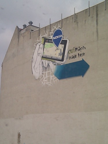
This grand painting style, part graffiti, part mural, part art seems to be iconic to a lot of the Mitte area of what used to be East Berlin. With this in mind, it's good to see that Nokia has decided to join in with this peculiarly Berlin trait with its own contribution, telling visitors walking along Invalidenstraße towards Nordbahnhof precisely what goes on in the Nokia Gate5 offices ... Ovi Maps, made here.

Ovi Maps. Made here. In Berlin