New Vaguely Rude Places Map Base Map Tiles
The Vaguely Rude Places Map has had a minor behind-the-scenes update. Here, look at it in all its profane geospatial glory.
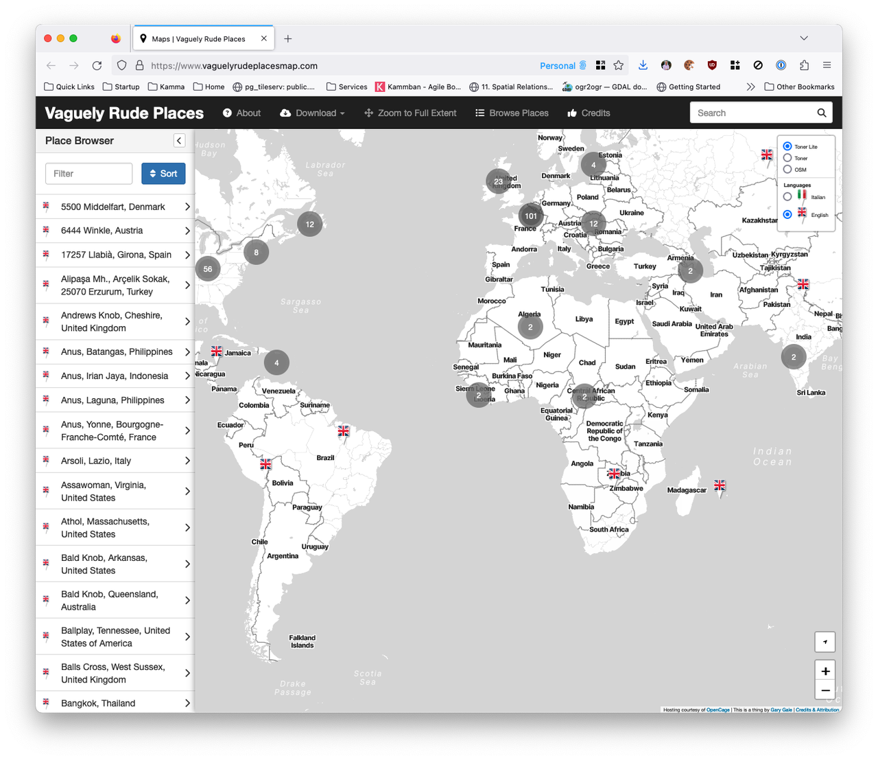
The Vaguely Rude Places Map has had a minor behind-the-scenes update. Here, look at it in all its profane geospatial glory.
As the post COVID brain fog slowly clear and I get around to doing stuff I really meant to do but either couldn't summon up the energy to or just plain forgot about; it's time to tackle the growing list of issues and pull requests on the Vaguely Rude Places Map GitHub repo.
It's 2009 all over again. Or is it 2012? After a 2009 launch at SXSW, the much hyped location wars with Foursquare, Facebook Places and Google Latitude, acquisition by Facebook in 2011 and - to no one's surprise - shutting down in early 2012 ... Gowalla is back it seems.
Original co-founder Josh Williams is back at the helm and back at SXSW with the new Gowalla which looks awfully like the original Gowalla, only iOS only this time, with no web prescence to speak of and no Android app in the works or even planned.
But maybe things are different second time around. Rather than fighting it out with Foursquare and Swarm, this time once rival Dennis Crowley is on board as an investor. Only time will tell, but right now after re-registering my old account name (vicchi of course) after installing the app on my phone ... it's all a bit bare and waiting for people to add places. Of course, Foursquare started in just the same place but I have to scroll a long way into Central London to find some existing places to check-in to.
When I first made the Vaguely Rude Places Map in February of 2013 I had no idea what was going to happen. Since then it's gone viral multiple times, been the subject of three conference talks, talked about on two radio stations, been covered in loads of newspapers and viewed millions of times. I still find it wryly amusing that the most successful map I've made to date has had nothing to do with my day job.
Today is the 7th. of Maptember 2013 and that means I should be in Birmingham for the OpenStreetMap State Of The Map conference. But I'm not; I'm still at home in the suburbs of South West London. But I will still be appearing at SOTM. Virtually.
Due to the age old cliche of circumstances beyond my control, I can't be in Birmingham this weekend, despite submitting How To Make A Map Go Viral (In 8 Easy Steps) as a talk for the SOTM conference. But thanks to the wonders of modern digital technology, in other words, a screencast, my talk is still on the conference schedule, even if I'm not.
The talk is an update to one of the same title that I gave at London's GeoMob back in April of this year and was submitted to the SOTM committee with this abstract ...
In February of 2013 I mashed up a geocoded list of global place names and made a map of them using nothing more than Stamen's OSM based Toner tile-set and the Leaflet maps API. I then promptly forgot about it. But Twitter had other ideas and the Vaguely Rude Place Names map went viral resulting in a month's worth of media madness. This is the story of how the map came to be and what happened when traditional media met social media ... on a map. It's also the story of how the combination of rude names, innuendo and maps briefly appealed to people the world over.
When I learned that I wouldn't be able to go to Birmingham, the conference organisers kindly suggested that maybe I might want to pre-record my talk instead. Which is just what I've done. You'll see it embedded below.
Back in February of this year, at the height of the madness that was the Vaguely Rude Places Map, Ed Freyfogle from London's #geomob meetup got in touch and asked me to come and tell the story behind the map. This is that story.
And so last night, in the Chadwick Lecture Theatre in the basement of London's UCL, after listening to some amazing presentations on building a map of mobile cell tower coverage, of building a seismically powered alternative to GPS and a whole host of other great talks, I took my place on the podium and started where any good story needs to start ... at the beginning.
I once wrote two posts saying that people are mistaking the context (location) for the end game and that location is (also) a key context, but most people don't know this. Two years or so after I wrote those posts, the concept of location based mobile services and location based apps shows no sign of dying off. I see lots of new location based apps and whilst they're almost always nice and glossy, not that many of them really grab you as a neat and innovative idea. But every so often, one does come along which makes you slap your forehead, like the scientists in the 80's ads for Tefal, and mutter under your breath ... that's so obvious, why didn't I think of that?
At the weekend myself and the rest of the Ovi Places team found ourselves re-geolocated from the Nokia office in Invalidenstraße in the Mitte district of Berlin to a new office in Schönhauser Allee in the Prenzlauer Berg district. While the office coffee hasn't improved, the view from my desk certainly has.
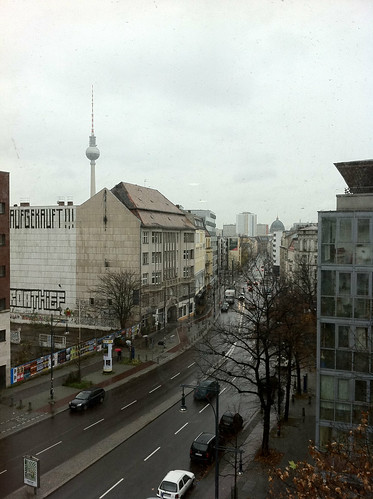
From left to right the view takes in the Fernsehturm, (East) Berlin's TV tower, Schönhauser Allee, looking towards Rosa-Luxemburg-Platz U-Bahn station on the U2 line and the dome of the Berlin Cathedral, better known as the Berliner Dom. I could get used to this view.
A week and a half ago Facebook finally launched their Places feature to a predictable media furore over location privacy, regardless of whether it's justified or not and, to location industry watchers at least, a strong sense of deja vu. Haven't we been here before?
Let's look at the key issues that seem to be getting people hot, bothered and generally up in arms.
I recently contributed an article to the OpenGeoData, the blog and podcast on open maps, data and OpenStreetMap, a snippet of which is below.
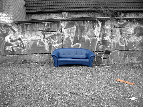
"Eddies," said Ford, "in the space-time continuum." "Ah," nodded Arthur, "is he? Is he?" "What?" said Ford. "Er, who," said Arthur, "is Eddy, then, exactly, then?" ... Why," he said, "is there a sofa in that field?" "I told you!" shouted Ford, leaping to his feet. "Eddies in the space-time continuum!" "And this is his sofa, is it?" asked Arthur, struggling to his feet and, he hoped, though not very optimistically, to his senses.
Jump onto Eddy's sofa for a moment and fast forward to a possible 2015.
After the location wars of 2010, the problems of mutually incompatible geographic identifiers have been solved with the formation of the Global Places Register. Founded by a fledgling startup on the outskirts of Bangalore, the GPR offered an open and free way for individuals and corporations to add their town, their business, their POI. All places added became part of the Global Places Translator, allowing Yahoo's WOEIDs to be transformed into OpenStreetMap Ways, into long/lat centroids, into GeoNames ids or even, for the nostalgic, Eastings and Northings.
... the rest of the article is on the OpenGeoData blog.
Photo Credits: Hell-G on Flickr.