Posts about stamen

2013 - The Year Of The Tangible Map And Return Of The Map As Art

Watercolor, the vast majority of digital maps can't really be classified as art. Despite the ability to style our own maps with relative ease, such as with Carto and MapBox's TileMill, today's maps tend towards the data rich, factual end of the map spectrum. Compare and contrast a regular digital map, on your phone, on your tablet or on a web site in your laptop's browser with a map such as Hemispheriu[m] ab aequinoctiali linea, ad circulu[m] Poli Arctici and you'll see what I mean (and if you don't browse the Norman. B. Leventhal Map Center's Flickr stream you really should).
Looking back at the conference talks I gave and the posts I wrote in 2012, two themes are evident.

The first theme is that while there's some utterly gorgeous digital maps being produced these days, such as Stamen's Watercolor, the vast majority of digital maps can't really be classified as art. Despite the ability to style our own maps with relative ease, such as with Carto and MapBox's TileMill, today's maps tend towards the data rich, factual end of the map spectrum. Compare and contrast a regular digital map, on your phone, on your tablet or on a web site in your laptop's browser with a map such as Hemispheriu[m] ab aequinoctiali linea, ad circulu[m] Poli Arctici and you'll see what I mean (and if you don't browse the Norman. B. Leventhal Map Center's Flickr stream you really should).

Hemispheriu[m] ab aequinoctiali linea, ad circulu[m] Poli Arctici

The second theme is that despite the abundance of maps that surround us these days, a digital map is almost by definition an intangible thing. It's a view port, hand crafted by a digital cartographer, on a mass of hidden, underlying spatial data. It's ephemeral. Switch off your phone, your tablet, your sat nav or your computer and the map ... vanishes. Until the next time you hit the "on" button, the electrons flow again and the map re-appears. But it's still intangible, despite the irony that a lot of maps these days are interacted with via a touch interface; we tap, poke, prod and swipe our maps, but they're not really there.

But maybe 2013 will be both the year of the tangible map and the year of the map as art. It might be if the closing days of 2012 are anything to go by.

On December 8th, 2012, David Overton's SplashMaps made their funding total on Kickstarter. A SplashMap is a real outdoor map, derived from (digital) open data, but rendered on a light and weatherproof fabric. It's a tangible map in the truest sense of the word; one you can fold up or even crumple up and stick in your pocket, safe in the knowledge that it won't fade away. There's no "off" switch for this map. As one of the SplashMap funders, I'll have a chance to get my hands on one in the literal sense of the word in a couple of months, once they hit production. So more about this map in a future post.

The other map that is both 100% tangible and 100% art is the awesomely talented Anna Butler's Grand Map Of London. A modern day map of the UK's capital city, digital in origin, lovingly hand drawn in the style of the 1800s and printed, yes, printed on canvas. It's a map worthy of the phrase "the map as art" and when I first saw one and handled one in late November of 2012 I wanted one, right there and then.

Grand Map Of London

And then, on Saturday, December 29th 2012, Mark Iliffe and I met Anna for a coffee in the Espresso Bar of the British Library on London's Euston Road and out of the blue, Anna handed over a long cardboard tube containing my own, my very own, Grand Map Of London. People nearby looked on, slightly non-plussed as I crowed like a happy baby, promptly unrolled the map over the table and just looked and touched. The next half an hour or so pretty much vanished as I pored over and luxuriated in the map, lost in the details and revelling in the map under my hands. Truly this is a tangible map which is itself art.

I've often said, half in truth, half in jest, that I'd love a big, as big as I can get, map of London on my wall, probably one of Stamen's Watercolor maps. But Anna's Grand Map Of London will be getting a suitable frame and sitting on my wall, just as soon as my local framing shop opens after the New Year break.

Grand Map Of London

Two maps to wrap up 2012. Both tangible, both digital in origin, both made for looking, touching and feeling. One clever, innovative and utterly practical and one a map you can keep coming back to and which reveals more artistic cleverness each time you look at it.

2013 is shaping up to be a "year of the map" in ways I'd never had hoped for at the start of 2012.

You Are Here; Map Wallpaper For Your Laptop

map wallpaper as a mild form of pejorative; meaning maps that are great for showing geographical context but which don't really show anything else. I'm also guilty of overusing the phrase eye candy; something which is eye catching but ultimately superficial.

Then along comes an eye candy map wallpaper app for my MacBook Pro and all pejoratives are instantly replaced with superlatives. Yes, this is eye candy. Yes, this is map wallpaper. But in this case the geographical context is spot on and it's definitely eye catching without being superficial in any way.

I've recently been guilty of using the term map wallpaper as a mild form of pejorative; meaning maps that are great for showing geographical context but which don't really show anything else. I'm also guilty of overusing the phrase eye candy; something which is eye catching but ultimately superficial.

Then along comes an eye candy map wallpaper app for my MacBook Pro and all pejoratives are instantly replaced with superlatives. Yes, this is eye candy. Yes, this is map wallpaper. But in this case the geographical context is spot on and it's definitely eye catching without being superficial in any way.

The man behind this wonderful piece of geolocated satellite imagery is Tom Taylor, who has previously blown my mind with his Boundaries visualisation of how London's neighbourhoods are perceived by way of Flickr's Alpha shape files.

The app is Satellite Eyes which, once installed on your Mac (sorry Windows and Linux users, you can't come to the party), hooks into the geolocation functionality built into the operating system and pulls down Bing's satellite imagery and uses it for your wallpaper, centred around your current location, such as where I live in the wilds of South West London.

Move around a city with your laptop moving with you and the imagery updates itself. Yesterday morning I was in London's Soho Square and sure enough, my laptop knew this and showed me, together with an overhead view of the construction sites for London's CrossRail project.

Map wallpaper in the truest sense of the word. What isn't there to like about this?

Phi, Lambda and (Slightly Embarassing) Temporality

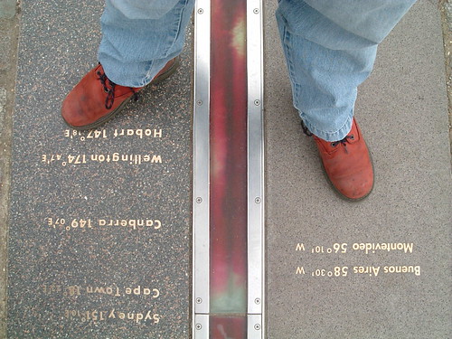
Astride The World

Which is why I think identifier systems, such as Yahoo's WOEID, add so much value. A WOEID adds a linked web of rich metadata, describing not only a point with a long/lat centroid, but also reinforces the concept of a place, with neighbouring and hierarchical relationships.

Coordinates describe the where of a place, identifiers such as WOEIDs describe the how of a place but both conveniently (in a slight embarrassed, foot shuffling short of way) overlook the when of a place.

Longitude and latitude have been formally used as a geographic coordinate system offset from the Greenwich Meridian since the International Meridian Conference of 1884 in Washington D.C.

As a spatial coordinate system, longitude (abbreviated as φ, or phi) and latitude ( λ, or lambda) work very well in defining a point on the surface of the Earth. But to gain further meaning from a long/lat pair you either need some clever algorithmics or you need to plot the long/lat point on a map which even then will yield information only as good as that which is rendered on the map itself.

Astride The World

Which is why I think identifier systems, such as Yahoo's WOEID, add so much value. A WOEID adds a linked web of rich metadata, describing not only a point with a long/lat centroid, but also reinforces the concept of a place, with neighbouring and hierarchical relationships.

Coordinates describe the where of a place, identifiers such as WOEIDs describe the how of a place but both conveniently (in a slight embarrassed, foot shuffling short of way) overlook the when of a place.

Former Flickr geo-hacker and current Stamen Design geo-hacker, Aaron Cope, posted a way around the temporality problem on his blog this evening, describing spacetimeid, a web app which encodes and decodes a 64-bit identifier combining x, y and z coordinates.

So far, so timely; a spacetimeid allows us to describe not only a point but also a time. The logical next step to this is to allow the encoding of a WOEID, that includes a long/lat centroid, with a time range. Two immediate use cases spring to mind.

Firstly, this allows us to represent places which have a small temporal range, such as festival or concert venues; this is frequently referred to as The Burning Man Problem, after the annual festival of the same name. During the duration of the festival Burning Man exists as a concrete place, outside of the festival timescales the site of the festival is empty land.

Burning Man 2007

Secondly, this allows us to represent changes in places over a large temporal range, which can be used to rectify historical maps and show the change in a place over a number of years.

I pinged Aaron a mail on this, saying "Encode temporal information in range format plus WOEIDs ? ... Thinking a WOEID for Burning Man or similar here". He replied a few minutes later with "Yes, that would be easy enough to do if the (x) is the WOEID and the (y) time. I can add that later". Followed, in the time it's taken me to write this post, with "Ask and all that ... https://spacetimeid.appspot.com/woe/encode/44418/1268854022".

Now all we need to do is get this used in the real world and the slightly embarassing problem of temporality will have been solved once and for all. Easy isn't it?

Photo Credits: Foxgrrl and Kaptain Kobold on Flickr.