A Bipolar Attitude To Aerial And Satellite Imagery Plus Maps Fear, Uncertainty And Doubt
Maps and map imagery seem to be back in the news. Google's recent map update and immense speculation about Apple's "will they, won't they" replacement for the current Google Maps app on iOS seems to be spilling over from the usual tech media into mainstream news.
Firstly, the UK's Daily Telegraph, a "quality broadsheet" seems to have just discovered that today's digital maps also have satellite imagery. It's not entirely clear how this is news, let alone current news. Navteq has had satellite imagery as part of its' maps since the mid 1980's and Google has also included satellite imagery in Google Maps since the mid 2000's. But linked to Apple's recent acquisition of 3D imagery specialists C3, we're told to anticipate a "private fleet of aeroplanes equipped with military standard cameras to produce 3D maps so accurate they could film people in their homes through skylights". The middle market tabloid Daily Mail has also picked up on this story, running with the headline "Spies in the sky that no one will regulate".
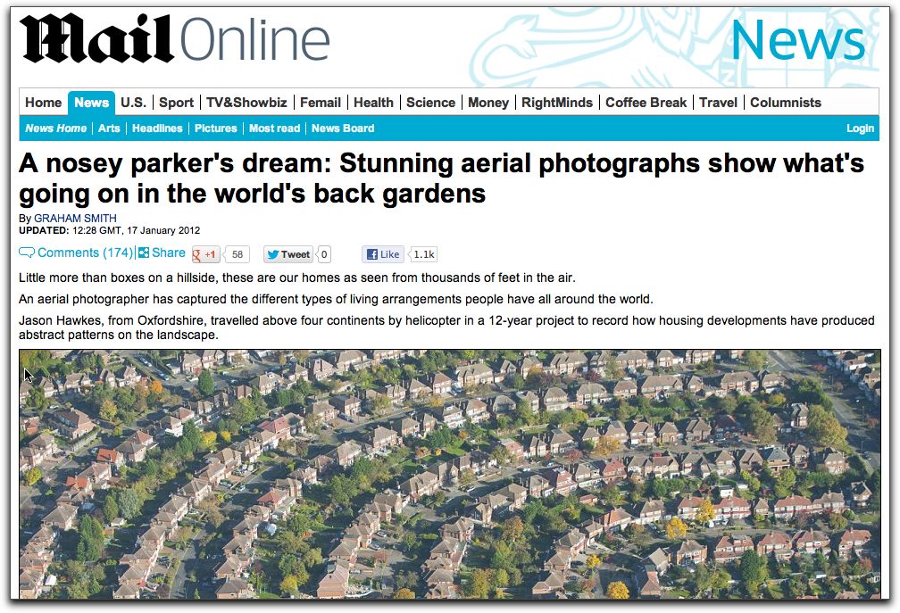
Yet only in January of this year, the Daily Mail published a series of extremely detailed aerial images under the headline "A nosey parker's dream; Stunning aerial photographs show what's going on in the world's back gardens". Apart from the slightly sensationalistic "nosey parker" reference, this six month old article seems to positively luxuriate in the high altitude photography. As Google's Ed Parsons pithily points out, this is another case of "editorial integrity by the Daily Mail".
Meanwhile, digital mapping provider TomTom, who acquired Tele Atlas in 2008 has produced what's often described as a FUD piece (fear, uncertainty and doubt) on digital map data produced by OpenStreepMap. The article starts off well
"The concept of open source mapping is a very exciting one. As various technologies become more accessible, volunteer mappers can collect information and collaborate to produce shared maps. They’re cheap to make, licensing is often free or very low-cost, and users benefit from the knowledge of a large community of updaters."
So far, so good. OSM has been gaining a lot of traction and attention over recent months as Nestoria, Apple (for iPhoto on the iPad), Wikipedia and Foursquare all adopted OSM maps to power their spatial visualisations. But not, it's worth noting, to power turn-by-turn navigation applications. But according to TomTom, all is not well with this.
Despite the positives, recent studies have highlighted some major drawbacks of open source mapping, specifically with regard to safety, accuracy and reliability. In one particular instance, a leading open source map was compared against a professional TomTom map, and shown to have a third less residential road coverage and 16% less basic map attributes such as street names. Worse still, it blended pedestrian and car map geometry, and included 'a high number of fields and forest trails' classified as roads.
Interestingly, this view from TomTom clashes somewhat with a 2011 study comparing TomTom and OpenStreetMap in Germany which concluded that
"With a relative completeness comparison between the OSM database and TomTom's commercial dataset, we proved that OSM provides 27% more data within Germany with regard to the total street network and route information for pedestrians."
So why highlight the difference between OSM and TomTom data now? As TechDirt notes in its' commentary on this topic
"The fact that TomTom has chosen to highlight this current deficiency in OpenStreetMap shows two things. First, that it is watching the open source alternative very closely, and secondly, that it is sufficiently worried by what it sees to start sowing some FUD in people's minds. But as history has shown with both open source server software and open source encyclopaedias, once vendors of proprietary systems adopt such a tactic against up-and-coming free rivals, it's a clear sign that it's already too late to do anything about it, and that their days of undisputed dominance are numbered."
Whether that's a fair and accurate summary of this remains to be seen, but what this does prove it that just as I've been saying for the last two years that there is no one single authoriative source of Place data and there probably never will, so there is no one single authoriative map and likewise, there probably never will.
Without meaning to trivialise the adoption of OSM by Wikipedia, Foursquare et al, these maps are what might be termed map wallpaper; great for showing geographical and geospatial context for information. The high level of accuracy and internal data attributes needed to produce a turn-by-turn navigation system simply isn't needed here. Which makes TomTom's evaluation of OSM all the more puzzling.


