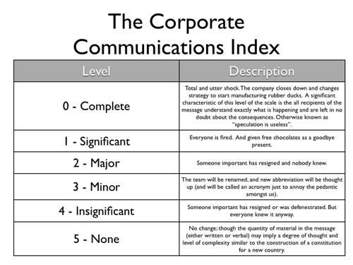
The Corporate Communications Index
If you work for a company with more than one member of staff, you'll be familiar with corporate pronouncements. Sometimes these are easy to digest, they're masterpieces of language; you know exactly what they're saying and more importantly what impact the pronouncement has on you and on your job. But sometime you read them and realise though you've read words and sentences you really have no idea what is supposed to be imparted by the words you've just read. With this in mind, I offer up the Corporate Communications Index. A simple, easy to read and digest table, which allows you to easily determine whether your job is safe or whether now would be a really really good time to polish your resume a little bit.
I can't take the credit for this work though; this piece of ever so slightly twisted genius is down to Jenny Allen who doesn't blog much, if at all. Consider me merely the messenger here, if you will.