Posts categorised as "blog"

Getting You There; The Battle Between PND, Mobile And Car

Attempts to predict the growth, success and uptake of technology are rife. Accurate predictions, less so. "There's no reason for any individual to have a computer in his home", said Ken Olsen, then founder and CEO of DEC in 1977. "I think there is a world market for maybe 5 computers" is apocryphally attributed to Thomas Watson of IBM in 1943.

It's easy to say "well ... duh" with the benefit of hindsight in 2010 but consider this. The first generation of in-car GPS units appeared in 1996. If anyone had told you that 14 years later you'd be running something infinitely more sophisticated and customisable, more powerful than one of Olsen's DEC VAX computers that I started out on, on a device that you stuck in your pocket and which, by the way connected to a global network of computers and was also a telephone, you'd probably not have believed them or suggested that at a minimum they cut their coffee intake back.
Two Weeks In; Of Dog Food, Mobile Handsets and Finnish Doors

Two weeks into the Nokia and Ovi experience and I can finally pause and catch my breath. It's been an intense two weeks and asking me what my impressions are of Nokia are akin to putting someone at the top of a very large, very steep and very fast roller coaster, watching them plummet down and then, before they're even out of their seat, asking them to comment on what the scenery was like. So I won't even try to comment on the scenery and will instead merely record the four things that have stuck in my mind.

I've been busy. I've been very busy. I've also been at home for all of two days in the last two weeks and whilst video chatting with my family over Skype is better than a plain old fashioned voice call it's no substitute for being at home more; but things will settle down into a more manageable routine over the coming weeks. Being busy has meant that I've kept my head down and tried to assimilate all the new information with which I'm being bombarded, a fact that's not gone unnoticed by Chris Osborne ... "severe drop off in @vicchi's bloggage and tweetage levels, means that maybe, just maybe, he is actually doing some work these days". Quite.

When Maps and Data Collide They Produce ... Art?

Last month I wrote that a map says as much about the fears, hopes, dreams and prejudices of its target audience as it does about the relationship of places on the surface of the Earth. With the benefit of hindsight I think I was only half way right.

Sometimes a map becomes more than just a spatial representation and becomes something else.

Sometimes a data visualisation becomes more than just the underlying data and almost takes on a life of its own.

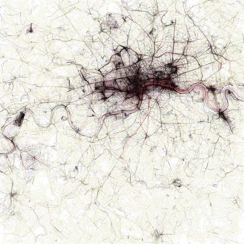
When these two things meet or collide the results can be spectacularly compelling and produce, unintentionally ... art? Look at the image below ... filigree lace work? Crochet for the deranged of mind? Silk for the sociopath? Macrame for the mad? Sadly none of the above.

The Geotaggers' World Atlas #2: London

It's instead an image from the Geotagger's World Atlas but it's still unintentionally beautiful.

Locating The Next Role; The Yahoo! Years

Looking back at my career over the last 20 or so years, it's immediately apparent that it's always been a bit geo. Geophysical seismic survey processing for natural resources (OK, mostly for oil and gas) for Digicon ... geo. Setting up operations for ERS-1, the European Space Agency's first remote sensing synthetic aperture radar satellite ... geo and rocket science. Short wave radio frequency planning to enable the BBC World Service to get transmissions into countries who would much prefer the BBC didn't broadcast there ... geo. Deploying the first geo-targeted ad system and rolling out a global place based view of the world internally and to the external developer community for Yahoo! ... totally geo. Granted, there were other roles which had no geo context whatsoever but I always seem to keep coming back to this vague and nebulous mixture of place, location, maps and geography that we term geo.

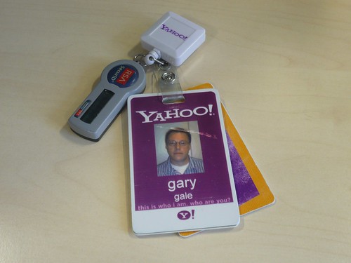
this is who I am, who are you?

Some 4 years ago (actually 3 years and 10 months but let's round up for the sake of convenience) I wasn't really looking for a new role, but the opportunity arose to come and lead and engineering team for Yahoo! Now, four years later, it's time to move onto another role, but more of that in a moment.

Curiously Cartographic Creations #3 - The Special Relationship

Odd map of the London Underground? Check. Maps of how Swedes and Hungarians see Europe? Check. Ah ... but what about how our neighbours across the Atlantic see the world? You know, the country that has a special relationship with the United Kingdom? I have just the very thing for you. Let's start with a nice simplified version of the world.

The World according to America

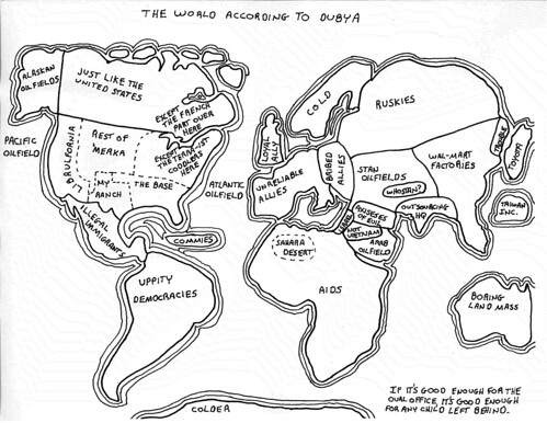
He may no longer be Mr. President but apparently George. W. Bush had a curious grasp of the world's geography.

The World According to Dubya

Keeping with the theme of President of the United States, this highly colourful view of the world comes from the mind of a Mr. Reagan. Allegedly.

The World According to Ronald Reagan

Photo Credits: irobot00 on Flickr.

Curiously Cartographic Creations #2 - Alternative Maps Of Europe

In the first of this occasional series, I looked at a curiously familiar but not quite right map of the London Underground evilly designed for tourists. In this second part of the series, it's time to cast out gaze out across the English Channel to Europe and how two of the member states see the European Union.

First there's how the Swedes see Europe; Britain is characterised by inventing soccer, inventing hooligans and beer (all three of which may be related) amongst others. The other European countries don't fare much better.

Europe according to the Swedes

Heading South and slightly East is the self styled Chosen Nation of Hungary. While the descriptions are mostly one or two words, they're not that flattering.  Britain is simply jobs, while other member states are characterised as tourist hordes, pizza, last minute hotels and beer land.

Europe according to the Hungarians

Crystal Ball Gazing Part 2 - Eddy's Sofa and The Nightmare of a Single Global Places Register

I recently contributed an article to the OpenGeoData, the blog and podcast on open maps, data and OpenStreetMap, a snippet of which is below.

"Eddies," said Ford, "in the space-time continuum." "Ah," nodded Arthur, "is he? Is he?" "What?" said Ford. "Er, who," said Arthur, "is Eddy, then, exactly, then?" ... Why," he said, "is there a sofa in that field?" "I told you!" shouted Ford, leaping to his feet. "Eddies in the space-time continuum!" "And this is his sofa, is it?" asked Arthur, struggling to his feet and, he hoped, though not very optimistically, to his senses.

Jump onto Eddy's sofa for a moment and fast forward to a possible 2015.

After the location wars of 2010, the problems of mutually incompatible geographic identifiers have been solved with the formation of the Global Places Register. Founded by a fledgling startup on the outskirts of Bangalore, the GPR offered an open and free way for individuals and corporations to add their town, their business, their POI. All places added became part of the Global Places Translator, allowing Yahoo's WOEIDs to be transformed into OpenStreetMap Ways, into long/lat centroids, into GeoNames ids or even, for the nostalgic, Eastings and Northings.

Sofa im Regen

... the rest of the article is on the OpenGeoData blog.

Photo Credits: Hell-G on Flickr.

And In A Change To Our Scheduled Programming ...

For a variety of reasons I'm sadly not going to be speaking at this year's Telematics event in Detroit in a few week's time and neither will I be at State of the Map.

The variety of reasons are both personal and based on my departure from Yahoo! at the end of this week and that the Telematics conference is coincident with my first week with [redacted]; I don't yet have a clearly articulated story with regards to [redacted] and I don't just want to retread the Yahoo! location and place story.

(untitled)

However I do plan to be speaking at the Location Business Summit USA in San Jose in September and in the same month I'll be chairing the first w3gconf in the UK. All of which provides ample scope for a modicum of geotasticness.

Photo Credits: iwasacamera on Flickr.

"But if you tell people what's going on they're going to expect it in the future"

Next time you head out of London's Waterloo station keep your eyes peeled as you come through the ticket barriers; if you're lucky you'll see one of the small display screens that are usually covered by an opaque lid. At first sight these seem to be a mirror of the larger departure boards on the main concourse but these screens tell the drivers which platform they need to be on for their train before the main concourse screens update.

Why is this interesting? Well, tonight the trains in and out of Waterloo were severely disrupted by something going on at Clapham Junction, no one seemed to know what exactly but the general consensus amongst the station staff was that it was probably related to a train.

Train departures were still displayed on the main board with a platform number, but after it became apparent that the service wasn't going anywhere, each departure cycled through on time, delayed and finally cancelled.

After my train home suffered this fate I trudged to the end of the platform where a member of the SouthWest Trains was looking at one of these driver's display screens and was actually dispensing useful information. Admittedly the information seemed to be "catch the Tube if you can" but that was still useful.

Crystal Ball Gazing Part 1 - The AGI Foresight Study

Way, way back in the deep dark past, Autumn 2009 to be precise, myself and several other people with an opinion on matters geo were asked to contribute a paper towards the Association for Geographic Information's 2015 Foresight Study.

The geographic information industry is undergoing radical change. Stimulated by technology and social developments, the balance of power between existing and new players is shifting. Government policy is also undergoing transformation with the publication of the UK Location Strategy, INSPIRE, the Marine & Coastal Access Bill and a new business model for Ordnance Survey. The economic strictures under which the public and private sectors will need to operate, as the UK attempts to handle enormous public debt, are also certain to drive changes in market dynamics.

There can be little doubt that in 5 years the industry will look very different to how it does today.

As the industry association, the Association for Geographic Information (AGI) needs to be sure it can continue to deliver its central mission to serve and represent our current and future members through these changes. In order to do so, we need to better understand what these changes are likely to be and how they will impact the geospatial industry and its customers