Posts tagged as "cartography"

The Union Of Subsidized Farmers, Mummy and Slayers Of Virgins - More Mapping Madness

Yanko Tsvetkov, visual artist, graphic designer and illustrator, has been at it again producing more mapping madness and cartographical curiosities. The man behind the map of Europe according to the Hungarians has produced another crop of somewhat subjective maps of Europe, where the United Kingdom comes under the headings of The Union Of Subsidized Farmers (Where I Live), Mummy (according to the USA), Slayers Of Virgins (according to France) and Enigma Code Hackers (according to Germany). Apparently.

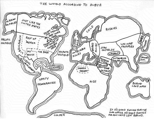
Here's a couple of examples; Europe According To The USA ...

Europe According to the United States of America

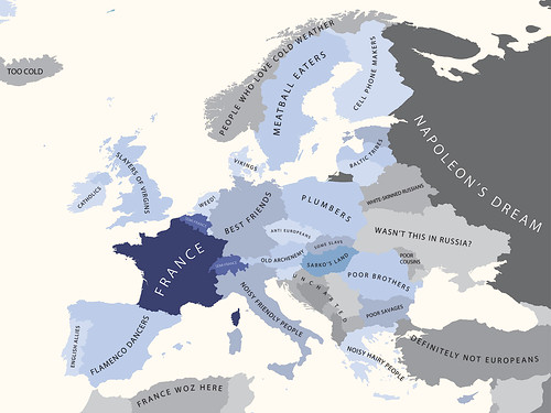
... and Europe According To The French.

Europe According to the French

Head over to his mapping stereotypes project page for the rest. It's mapping, but not as we know it, and as Yanko aptly puts it, "a sense of humour is highly recommended".

Cartographically Speaking; Data (Lots), Maps (Not So Much), Problems (Many)

In September I'll be at the 46th. Annual Society of Cartographers Summer School at the University of Manchester where I'm lucky enough to have been asked to give a talk on geographic data. This topic should come as no surprise to anyone who's come across one of my blog posts.

I'll be talking about Welcome To The World Of The Geo Data Silo; Where Closed Data Is Open And Open Data Is Closed; the talk abstract is now up on the SoC web site and it's reproduced below.

The Uncertainty Principle Of Maps Sites (And Eddie Izzard)

I should start off by saying that I don't mean mapping web sites. There's no Ovi, Yahoo!, Google or OpenStreetMap web sites in this post. No, this is a blog post about Eddie Izzard (at least slightly), Heisenberg's Uncertainty Principle (even more ephmerally), the (death of) RSS, maps and cartography (generally) and (in the main) web sites about maps and cartography.

A strange set of bedfellows you might think (you might also think I've been overdosing on LISP as there's way way too many parentheses in the first two paragraphs alone) ... but bear with me.

Eddie Izzard, in his Dress To Kill stage show ("cake or death"), was musing on the way in which people perceive history and this got me to thinking about RSS. But first, this is what he said ...

Yes, and I grew up in Europe, where the history comes from. Oh, yeah. You tear your history down, man! “30 years old, let's smash it to the floor and put a car park here!" I have seen it in stories. I saw something in a program on something in Miami, and they were saying, "We've redecorated this building to how it looked over 50 years ago!" And people were going, "No, surely not, no. No one was alive then!"

When Maps and Data Collide They Produce ... Art?

Last month I wrote that a map says as much about the fears, hopes, dreams and prejudices of its target audience as it does about the relationship of places on the surface of the Earth. With the benefit of hindsight I think I was only half way right.

Sometimes a map becomes more than just a spatial representation and becomes something else.

Sometimes a data visualisation becomes more than just the underlying data and almost takes on a life of its own.

When these two things meet or collide the results can be spectacularly compelling and produce, unintentionally ... art? Look at the image below ... filigree lace work? Crochet for the deranged of mind? Silk for the sociopath? Macrame for the mad? Sadly none of the above.

The Geotaggers' World Atlas #2: London

It's instead an image from the Geotagger's World Atlas but it's still unintentionally beautiful.

Curiously Cartographic Creations #3 - The Special Relationship

Odd map of the London Underground? Check. Maps of how Swedes and Hungarians see Europe? Check. Ah ... but what about how our neighbours across the Atlantic see the world? You know, the country that has a special relationship with the United Kingdom? I have just the very thing for you. Let's start with a nice simplified version of the world.

The World according to America

He may no longer be Mr. President but apparently George. W. Bush had a curious grasp of the world's geography.

The World According to Dubya

Keeping with the theme of President of the United States, this highly colourful view of the world comes from the mind of a Mr. Reagan. Allegedly.

The World According to Ronald Reagan

Photo Credits: irobot00 on Flickr.

Curiously Cartographic Creations #2 - Alternative Maps Of Europe

In the first of this occasional series, I looked at a curiously familiar but not quite right map of the London Underground evilly designed for tourists. In this second part of the series, it's time to cast out gaze out across the English Channel to Europe and how two of the member states see the European Union.

First there's how the Swedes see Europe; Britain is characterised by inventing soccer, inventing hooligans and beer (all three of which may be related) amongst others. The other European countries don't fare much better.

Europe according to the Swedes

Heading South and slightly East is the self styled Chosen Nation of Hungary. While the descriptions are mostly one or two words, they're not that flattering.  Britain is simply jobs, while other member states are characterised as tourist hordes, pizza, last minute hotels and beer land.

Europe according to the Hungarians