Posts tagged as "geotagged"

What Do You Call The Opposite Of Mapping?

Dutch computer scientist Edsger Dijkstra, who was awarded the Turing Prize in 1972 is reported to have once said ...

If debugging is the process of removing bugs, then programming must be the process of putting them in.

With this in mind, if the process of taking geographical information and making this into a map is called mapping ... what do you call the opposite, the process where you take a map and deconstruct it back to what makes up the map in the first place.

Un-mapping? Anti-mapping? De-atlasing? Whatever you call it, you start out with a map and you end up with an oddly compelling form of art. Which is just what French artist Armelle Caron has been doing.

Start with the map. Let's take a map of Berlin. If you've spent any time in this city, the map will look pretty familiar. It's not the most granular or small scale of maps, but that doesn't matter. What happens next is most definitely art and is akin to magic.

Map Wars; Are Apple's Maps Really That Bad?

Making a map isn't easy. Making a map of streets and land features is hard. Making a map of streets and land features that stays up to date is harder. Making a map of streets, features and places, businesses, services, points of interest is harder still. Making a map of all of the previous that stays up to date is really hard. Making a map with all of the previous, wrapping it up in an app that runs on your smartphone and making it useable is verging on insanely difficult. Yet that's what Google and Nokia have been doing and with the release of iOS 6, that's what Apple is now doing as well. So how is Apple doing?

The Map Of The World According To The London Underground

Yes, it's another map. Yes, it's another map of the London Tube system. But wait ... something's not quite right.

Surely the Piccadilly Line ends at Uxbridge, Heathrow Airport and Cockfosters and not at Seattle, Buenos Aires and St. Petersburg? Doesn't the Northern Line run from Edgeware and High Barnet to Morden and not from Helsinki to Mumbai?

Maybe if the London Underground did take over the world, including 3 tunnels across the Atlantic Ocean, this is what the Tube Map might look like.

World Metro Map by Mark Ovenden

Photo Credits: Annie Mole on Flickr.

The Olympic Tube Map

Not all maps are created equal. I've always had a soft spot for maps of the London Underground network ever since I saw one on the back of an old London A-Z street map far too many years ago.

In case you hadn't noticed, London hosted the 2012 Olympic Games a few weeks ago so what could be more natural than a map of the Tube with famous Olympic athletes in the place of the more familiar and geographically correct station names. Maybe Chris Boardman instead of Swiss Cottage, Victoria Pendleton instead of St. John's Wood or Daley Thompson in place of Baker Street?

Hop over to the Transport for London web site and for between £3.99 and £49.00, the Olympic Legends Tube Map can be yours. I certainly want one. Huge amounts of kudos go to my darling wife for spotting this in the first place.

Making Maps Underground

Warning. This post contains a sweeping generalisation. Yes, I know that Places are not just part of today's digital maps; see the James Fee and Tyler Bell hangout The One Where Tyler Bell Defines Big Data as a proof point. But for the sake of this post, just assume that Places and maps are synonymous.

It's never been easier to make a map. Correction. It's never been easier to contribute to a map. Today we seem to be makingcontributing to maps everywhere, even underground, or should I say Underground?

To makecontribute to a map, you used to have to be a professional map maker, with easy access to an arsenal of surveying or an industrial grade GPS.

Maps, Maps And MOAR Maps At The Society Of Cartographers And Expedia

Updated September 13th. 2012 with embedded YouTube video.

Wednesday September 5th. 2012 was a day of maps. To be precise, it was a day of maps, maps and MOAR maps. Two events, two talks, back to back. Packed choc-a-bloc full of maps. I also cheated slightly.

Firstly there was the International Cartographical Association's first session of the newly formed Commission on Neocartography. Cartography, neocartography, maps; what is there not to like? I'd previously spoken at the UK's Society of Cartographer's annual conference so it was great to be asked by Steve Chilton, SoC and Neocartography chair, to speak at the Neocartography Commission.

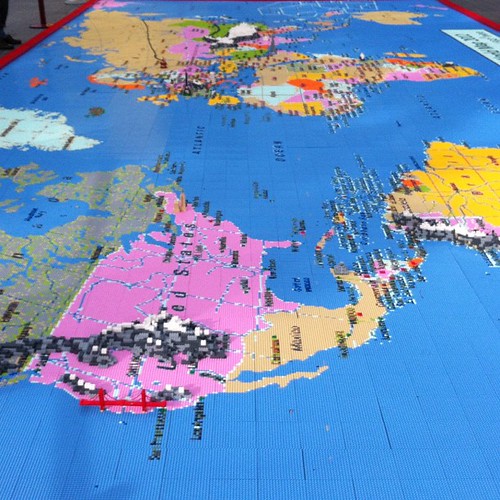
A Map Of The World In One Million Lego Bricks

Imagine for one moment that someone gave you in excess of a million lego bricks and four thousand lego building plates. Imagine also that you had around three week's worth of spare time.

What would you build?

To my mind, the first thing that should spring to mind is a massive map of the world. You've got enough bricks so making a map around 12 by 5 meters should do the trick.

A 1 Million Piece Lego Map Of The World.

Oddly enough, that's exactly what members of the public did on London's Southbank during the London 2012 Olympic Games.

Looking From San Francisco To London. In Lego.

If you want to see it for yourself, head over to the terraces outside the Royal Festival Hall but you'll have to hurry. The map will only be around until August 26th.